


Australia’s geospatial community will converge on Sydney next week for three days of learning and discussion.
Search results for "Spatial Vision"

Locate24 Vendor Focus: 1Spatial
In the run up to the Locate conference in May, we’re highlighting some of the companies you’ll be able to meet.
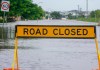
Spatial Digital Twin to be used in flood prediction
NSW’s SDT will visualise real-time rainfall and flood conditions using data from TPG’s mobile phone network.

Spatial Collaboration Portal survey results released
More than 80% of users view maps and data, with land parcel and property being the most popular data types.

Stewart Dunne joins Geospatial Council’s board
Dunne, the former Hydrographer of Australia, becomes a new, independent non-executive GCA Director

Space+Spatial 2030 Roadmap to be re-aligned
The Space+Spatial 2030 RoadMap is being adapted to reflect changing government objectives and national needs.

Kate Lundy appointed to Geospatial Council board
Lundy served for more than 19 years as a senator for the ACT, followed by a career in corporate leadership.

Victoria’s Geospatial Excellence Award winners
A wide range of Victorian individual and team geospatial efforts have been recognised with awards.

From maps to multiverse — what is geospatial?
Geospatial is more than an industry — it is a phenomenon that can change the world, says Woolpert’s Joe Seppi.
Kurloo: An Australian-first geospatial breakthrough
The story of the development of an intelligent positioning sensor technology, known as the Kurloo.


