


The City of Sydney has set targets to grow a cooler, more diverse, and resilient city with mapping technology.
PARTNER FEATURE
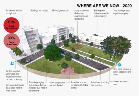
The City of Sydney intends to increase tree canopy cover from 19% to 27% and green cover from 33% to 40% by 2050, to help reduce the impacts of rising urban temperatures and improve community health and wellbeing.
Spatial analysis, using Esri’s ArcGIS suite, is one of the mechanisms through which the Council intends to reach its targets, providing its urban forest team spatial data to inform decisions and solutions relating to tree management. Since 2008, the team has consistently increased the City of Sydney local government area’s canopy cover — one of few councils and the only capital city in Australia to achieve this.
Surface temperatures in Australia have increased by 1.4°C since 1910, with projections for further increases by 2050. Experts are warning that neighbourhoods lacking sufficient tree cover will significantly impact residents’ amenity and liveability.
“Trees can last for well over 100 years, yet most people occupy their houses for less than 10 years. We must consider ourselves as custodians rather than masters, and nurture and improve our greenery for the benefit of following generations,” said Lord Mayor of Sydney, Clover Moore.

In the past decade, more than half of Greater Sydney’s neighbourhoods lost urban forest cover to population growth. Canopy trees help to cool surrounding hot air and surfaces, through shading and evaporative cooling. With Greater Sydney’s population expected to grow to 6.1 million by 2041, extreme heat islands, where zones of persistently high temperatures caused by concentrated artificial materials (buildings, pavement, bitumen) that absorb and emit the sun’s rays, rather than reflect it, are on the rise. A multi-pronged approach to managing Sydney’s biodiversity is important to counteract these warmer areas.
Growing cooler, diverse, resilient cities with ArcGIS
The analysis and interpretation of location-based (spatial) data has become an important tool for urban forest practice and management. City of Sydney has applied new spatial analysis techniques that reduce barriers to gather and calibrate localised environment data on a street-by-street basis, to provide greater insight and better manage the urban forest for the entire community — through more accurate projections and calculations.
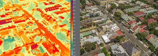
Data acquired from satellites, drones, LiDAR and aerial visuals taken by a camera mounted to an aircraft, form the bedrock foundations of the Council’s urban forest management program. The data allow spatial analysts and the urban forestry team to collaborate and identify trends.
Tree canopy analysis was first undertaken in 2010 using standard RGB aerial imagery and unclassified LiDAR. Over more than a decade, refinement in measurement has progressed to thermal and hyperspectral capture using ArborCarbon’s ‘ArborCam’. The team can now capture heat and the unique signatures of trees across 11 bands of imagery in high resolution.
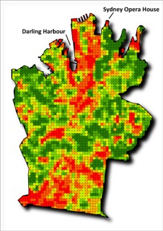
Analysis of the data involves establishing a grid of uniformly spaced reference points at 100 metres, spread across the Council area, totalling 2,600 reference points. At each reference point, canopy data is gathered and summarised from a buffer radius area surrounding it. This technique enables more equitable and resilient data analysis and mapping. Reference points with low scores can be prioritised for future planting opportunities.
Precision analytics identifies which trees are best suited to particular locations so that they can thrive in a changing climate, providing benefits for people and habitat for native fauna. The analytics also help the Council’s sustainability and resilience team to monitor neighbourhood temperatures and mitigate heat islands. The flow-on effects for residents, businesses, commuters and visitors include more attractive and comfortable outdoor spaces for everyday use. The benefits of better tree management are multi-dimensional — a cooler, calmer environment, improved mental and physical health and less demand on energy.
Using ArcGIS web maps and ArcGIS dashboards, the urban forest team can then map out specifications and make decisions about the type of trees to be planted to help grow a resilient and diverse tree canopy. The data guides the team to create new workflows, to predict, plan and mitigate the consequences of development and climate change and understand how heat islands, tree species, tree age and biodiversity influence the local environment.
Challenges of lost urban forest
Diversity of tree canopy ensures young trees are plentiful for the future while mature trees provide the full benefits of shade, air filtration and cooling. One mature tree can absorb 3,400 litres of stormwater over a year-long period and filter 27 kg of pollutants from the air. It can also provide a cooling effect equivalent to running 10 air conditioners. Diversity of tree species is also important for animals, to limit plant disease spread, and to avoid all trees reaching maturity at the same time.

Consulting community through GIS
To develop the award-winning Street Tree Master Plan 2023, the urban forest team consulted with the community through two separate ArcGIS Survey123 polls.
Residents could provide feedback on tree selection — there were up to five suitable species to choose from — before the draft Plan was adopted.
Additionally, residents could stay updated and informed as to which trees were selected for the street, and the rationale for the recommendation, through an ArcGIS interactive map and dashboard.
Spatial analysis was conducted on all streets to determine aspect, soil types, existing species, current coverage and relationship to assets such as overhead wires, kerbs and traffic islands.
ArcGIS Field Maps was used by arborists in the field while the tree management team monitored progress and diversity of selections from the office using ArcGIS dashboards.
In 2023, the Street Tree Master Plan won three Australian Institute of Landscape Architecture Awards, including the Award of Excellence for Landscape planning, the NSW Shadesmart Award, and the National Climate Positive Design Award.
Interact with the Greener Sydney Strategy
A geographic approach helps provide insight into the challenges of climate change and drives solutions for a sustainable future. User-friendly GIS tools act as platforms to share data with internal stakeholders and various publics to support accountability and transparency.
The City of Sydney developed a StoryMap demonstrating its strategy to meet its 2050 targets and its results to date. Visit https://bit.ly/GrowGC to explore.
Content supplied by Esri Australia and City of Sydney.
This article was first published in Issue 129 (Feb/Mar 2024) of Position magazine. Please consider subscribing.


