

The federal government has announced that Australia will join the Landsat 2030 International Partnerships Initiative, committing $207.4 million over four years as well as ongoing funding.
The Initiative, built around the upcoming next-generation Landsat NEXT satellites, is being led by NASA and the US Geological Survey.
The federal Minister for Resources and Northern Australia, Madeleine King, signed an in-principal agreement during a visit to Washington last month.
The funding allocation will be used to enhance the satellite ground station in Alice Springs, along with new data processing and analytics capabilities.
The triple-satellite mission, due for launch in 2030, will boost both temporal and spectral coverage, with the satellites spaced 120 degrees apart at an orbital altitude of 653 kilometres.
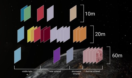
Landsat NEXT will have the following capabilities and characteristics:
- Number of spectral bands: 26
- Spatial resolution: 10-20 metres (VSWIR), 60 metres (atmospheric/TIR)
- Mean equatorial crossing time: 10:10am ± 5 minutes
- Single observatory repeat interval: 18 days
- Triplet constellation repeat interval: 6 days
- Global cataloguing grid system: WRS-3
- Scene size: 164 x 168 km
- Half angle field of view: 7.2 degrees
- Mission design life: 5 years
“Landsat data is vital for industries such as mining and agriculture and is an essential tool in managing natural disasters,” Minister King said. “The Landsat Next satellites will mean we can monitor Australia’s lands and coasts from space. It is the biggest and best selfie we could take of our great country.”
While the announcement will no doubt be welcomed by Australia’s Earth observation community, it does little to reduce Australia’s reliance upon overseas-provided satellite remote sensing systems.
It comes after the federal government cancelled the $1.2 billion National Space Mission for Earth Observation last year for “budget repair” purposes.
Australia is essentially entirely reliant on Earth observation (EO) satellites owned and operated by other countries or foreign private companies. This poses a substantial sovereign risk and leaves the country vulnerable to vast economic loss should access to those satellites be denied or interrupted.
In a 2021 report, Deloitte found that “Australia’s EO sector, and the benefits EO data generates for other industries, is exposed to a significant sovereign supply risk: Australia does not own or operate any EO satellite systems. At the same time, the threat of a DOS [denial of service] event is becoming increasingly real, particularly in the context of Australia’s role in the Global Observing System (GOS).”
The Deloitte report also said that “The annual economic cost of a DOS event for EO is estimated as follows:
- 81% of activity in the EO sector would almost immediately cease to exist as we know it. This equates to $226 million in lost (direct) value added.
- The Australian economy (GDP) would contract by $1.9 billion due to the disruption in activity by end users of EO data (based on currently available data).”
When the then federal treasurer Josh Frydenberg delivered the 2022–23 Budget, $38.5 million per annum was earmarked for four satellites. The overall program was promised $1.16 billion out to 2039… about $70 million annually.


