

A new program that aims to increase US and partner governments’ ability to sustainably manage land, surface water and resource use has been launched by the US Department of the Interior.
Known as the Landsat 2030 International Partnership Initiative, the program will take advantage of the new capabilities to be offered by Landsat Next Earth observation triple-satellite mission, which is due to launch in late 2030.
The long-running Landsat program is a partnership between the US Geological Survey (USGS) and NASA.
According to the US Government, “NASA is harmonising Landsat Earth observation satellite data with European partners to enable faster access to international datasets for use by farmers, city planners, and other decision makers.”
“Earth observations are vital in the face of a changing climate,” said Principal Deputy Assistant Secretary for Water and Science, Michael Brain.
“By combining Landsat’s long-term dataset and legacy of excellence with global partnership, the 2030 Initiative will provide actionable science that can help other science agencies, stakeholders, industry and academics tackle complex questions about how change is affecting landscapes, waterways and wildlife around the globe.”
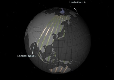
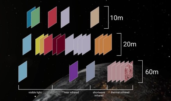
The Landsat Next mission will boost both temporal and spectral coverage, with three satellites (all launched on the same launch vehicle) spaced 120 degrees apart at an orbital altitude of 653 kilometres. It will have the following characteristics:
- Number of spectral bands: 26
- Spatial resolution: 10-20 metres (VSWIR), 60 metres (atmospheric/TIR)
- Mean equatorial crossing time: 10:10am ± 5 minutes
- Single observatory repeat interval: 18 days
- Triplet constellation repeat interval: 6 days
- Global cataloguing grid system: WRS-3
- Scene size: 164 x 168 km
- Half angle field of view: 7.2 degrees
- Mission design life: 5 years
“I think this is going to be a phenomenally capable instrument, with the biggest leap in Landsat capability since Landsat 4,” said Bruce Cook, NASA Landsat Next Project Scientist at NASA’s Goddard Space Flight Center.
“This is basically the first chance we’ve had to completely re-conceive the Landsat mission.”
“As the impacts of the climate crisis intensify in the United States and across the globe, Landsat satellites are crucial to providing data and imagery to help make science-based decisions on key issues including water use, wildfire impacts, coral reef degradation, glacier and ice-shelf retreat, and tropical deforestation,” said USGS Director, David Applegate.


