

A significant milestone has been reached in the roll out of Australia and New Zealand’s satellite-based positioning augmentation system — the Southern Positioning Augmentation Network or SouthPAN — with it reaching a service availability level of 99.5%, up from 95% previously.
SouthPAN is an initiative of the Australian and New Zealand governments, being implemented by Geoscience Australia (GA) and Toitū Te Whenua Land Information New Zealand.
Following a multi-year testbed phase, a contract was awarded to Lockheed-Martin Australia in 2022 for implementation of SouthPAN, with early open services to become available in September of that year.
Branch Head at GA’s Positioning Australia, Dr Martine Woolf, says the new milestone is “particularly exciting from a stakeholder perspective,” with users now able to have “much more confidence in relying on the services and greater assurance that they will experience minimal outages”.
“That obviously comes on the back of a few years of work that has taken the form of ongoing improvements in the infrastructure behind the SouthPAN system,” Dr Woolf said. “That includes building and operationalising a new uplink station in Uralla in NSW and other improvements in the whole system that sits behind SouthPAN, and that upgrade will continue. But we are now at the point that we can up the service availability to the level that we always envisioned it should be.”
The result is that users can now be assured that 99.5% of the time they need to use the SouthPAN service, it will be available. Dr Woolf adds that “We think it will be more than that… but we guarantee it to that level of 99.5%”.

So has the reliability been growing steadily or have there been incremental jumps?
“Probably a bit of both,” said Dr Woolf. “The reliability is determined by various things that are both within and not entirely within our control, which is why it probably never would be possible to set it to 100%.”
“We’ve been investing in new infrastructure that gives extra levels of redundancy and that clearly allows us then to bring that level of reliability up. You might not see that from the outside, but what you would see are less frequent outages,” Dr Woolf added.
“There are going to be outages [but] that could be due to something that sits outside the system itself. So there could be outages due to solar events or in equipment that at this point sits in the satellites that we can’t control.”
The SouthPAN signal is currently provided via a transponder aboard an interim satellite, with the next step being the launch of a dedicated bespoke transponder aboard the Inmarsat I-8 satellite, which is due to begin service in 2027.
An announcement is expected soon on the selection of a second, to-be-launched satellite that will provide a redundant SouthPAN signal. From that point on, there will always be two satellites in service.
Having two satellites will “enable us to achieve that guaranteed level of service,” said Dr Woolf. “One or the other would be able to achieve the level of service that we need [but having two] gives redundancy to the system.”
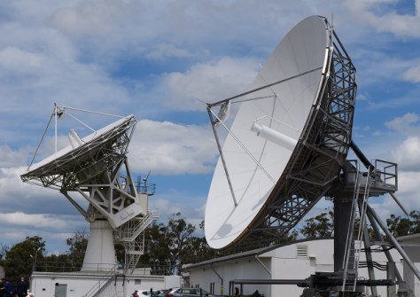
Redundancy extends to the ground segment, as well. There are to be two uplink sites — one at Uralla in northern New South Wales, and one at Invercargill in New Zealand — each of which will have two dish antennae. Uralla is operational, and Invercargill will soon be.
An oft-overlooked part of the SouthPAN system is the growing network of ground-based GNSS reference stations (GRS) strategically located across Australasia. Many in the geospatial sector will be familiar with the CORS network that provides positioning correction signals for surveying — the GRS are conceptually equivalent but engineered to higher design specifications, such as having dual communications links.
In the last few months there has been another exciting development in the service, with users now able to access the SouthPAN service not only through the satellite broadcast, but also via the Internet.
“It’s an alternative way of delivering the same services that we get through satellite broadcast, but it caters to a potentially different stakeholder group,” said Dr Woolf. “It just gives an additional opportunity and a different way of building this into new products. This Internet stream we think is potentially of interest to technologies that might be more applicable to wearable devices or mobile phones.”


