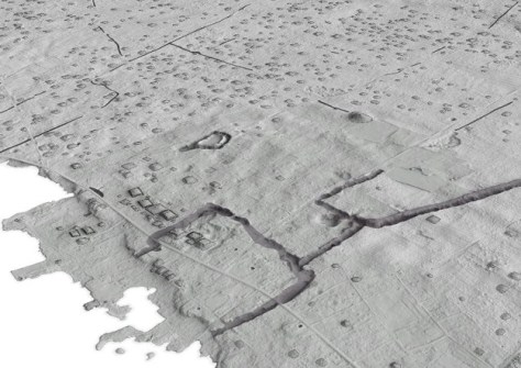
New evidence of one of the first cities in the Pacific shows they were established much earlier than previously thought, according to research from The Australian National University (ANU).
Lead author, PhD scholar Phillip Parton, said the new timeline also indicates that urbanisation in the Pacific was an indigenous innovation that developed before Western influence.
“Earth structures were being constructed in Tongatapu around AD 300. This is 700 years earlier than previously thought,” Mr Parton said.
“As settlements grew, they had to come up with new ways of supporting that growing population. This kind of set-up — what we call low density urbanisation — sets in motion huge social and economic change. People are interacting more and doing different kinds of work.”
The study, which has been published in the Journal of Archaeological Method and Theory, used aerial LiDAR scanning to map archaeological sites on the island of Tongatapu in Tonga.
In the paper, the authors state that “The vast quantities of data produced by lidar presents a unique opportunity to incorporate built environment data with approaches that are inclusive of all sectors of past societies, not just the social and political elite. The introduction of lidar as a tool to understanding built environments of the past has been transformative for tropical regions resulting in a reappraisal of our understanding of settlements in these landscapes…”
“The high accuracy lidar data provides unprecedented data on the built environment of Tongatapu that permits new analyses of the built environment,” the authors add.
Mr Parton said traditionally, studying urbanisation in the Pacific has been tricky due to challenges collecting data, but the new technology has changed that.
“We were able to combine high-tech mapping and archaeological fieldwork to understand what was happening in Tongatapu,” he said. “Having this type of information really adds to our understanding of early Pacific societies.”
“Urbanisation is not an area that had been investigated much until now. When people think of early cities they usually think of traditional old European cities with compact housing and windy cobblestone streets. This is a very different kind of city,” he added.
“But it shows the contribution of the Pacific to urban science. We can see clues that Tongatapu’s influence spread across the southwest Pacific Ocean between the 13th and 19th centuries.”


