The CSIRO has announced that a new NovaSAR-1 National Facility Datahub will be launched later this year.
According to the science agency, the new platform was selected after assessment of a number of providers and will provide enhanced capabilities and improved access to NovaSAR-1 data.
The new Datahub will use technology already utilised by the Earth Analytics Science & Innovation Platform (EASI).
CSIRO says it will minimise disruption to users during the transition period, and the Datahub will continue to be accessed at the same location.
In order to comply with the Privacy Act 1988, all users will need to complete a new registration process to ensure continued access.
More details about the new Datahub and instructions on how to renew registration will be released in the coming weeks. A new user guide will also be made available.
NovaSAR-1, developed by Surrey Satellite Technology in the UK, is a demonstrator project that produces medium- and high-resolution images of Earth using S-band (3.2 GHz, or 9.4 cm wavelength) synthetic aperture radar.
In September 2017, CSIRO purchased a 10% share of time on the satellite and operates that share as a national facility available to all Australian researchers.
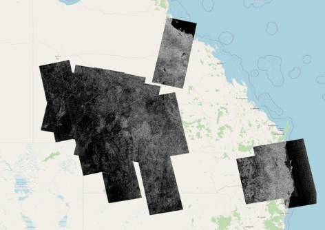
The access has already proven its worth, as can be seen in images taken during the flooding in NSW and Queensland in March 2025 caused by ex-cyclone Alfred.
The images were up to 784 km long and used a ScanSAR mode with 195 km swath width, both HH and HV polarisations and 50 m pixel resolution. That mode was chosen to maximise the area covered.
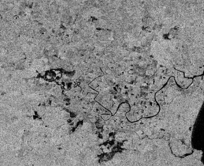

The HV image of flooding in New South Wales highlights areas of open water as low backscatter (dark in the image). The HH image also shows this low backscatter over open water, but with the addition of areas of higher backscatter (bright in the image) which correspond to flooding under vegetated conditions.
NovaSAR-1’s long radar wavelength is a big factor in the satellite’s ability to penetrate canopies to image double-bounce reflection off the water surface beneath.