

The World Settlement Footprint (WSF) Tracker and its dedicated online platform have been officially released.
The platform enables users to explore, analyse and download the dataset, while providing a range of tools to investigate how settlements have grown and changed, all at 10-metre resolution and with updates every six months.
A key feature of the WSF Tracker is its ability to monitor urban expansion with greater spatial accuracy, higher frequency and shorter lead time between satellite observation and publication of the dataset.
This makes it possible to move beyond static snapshots of urban growth and towards a more continuous understanding of how cities and settlements evolve.
Assessing urban areas’ exposure to hazards
The WSF Tracker builds upon the World Settlement Footprint (WSF) initiative led by the German Aerospace Center (DLR) to map and monitor human settlements and related characteristics of the built environment worldwide.
Developed jointly by DLR and MindEarth, and co-designed with the European Space Agency (ESA) and the World Bank, it extends the WSF framework with a new capability to monitor settlement dynamics over time.
Cities or urban environments (excluding roads) cover 0.6% of Earth’s land surface as of January 2026, according to data from WSF Tracker. And yet these urban areas are home to more than 57% of the human population — a figure that is projected to grow to 68% by 2050 according to UN data.
As built-up areas continue to expand, understanding where and how urban growth is taking place is becoming increasingly important.

In many regions, new development is occurring in areas exposed to flooding, extreme heat, seismic hazards, land subsidence and cyclones.
This means that buildings, infrastructure and economic activity may be increasingly concentrated in locations where climate and natural hazard risks are also evolving.
New analytical capabilities and insights
According to Fabio Cian, ESA representative to the World Bank, the WSF Tracker is more than a new dataset and platform.
“The combination of high spatial resolution, frequent updates and reduced lead time between observation and data availability makes the platform particularly relevant for operational and analytical applications,” he said.
“The fact that the platform is already informing World Bank activities highlights the importance of building solutions with a clear pathway to adoption, scaling and sustainability from the outset.”
WSF Tracker offers new analytical capabilities and insights, such as:
- monitoring settlement growth continuously from 2016 to 2026, rather than comparing only a few static reference years;
- quantifying the timing and pace of urban expansion at global, regional, national and city scales;
- identifying hotspots of rapid urban growth and emerging settlement patterns;
- supporting more timely analysis of urban dynamics through six-monthly updates and reduced latency between observation and data availability; and
- assessing settlement exposure to natural hazards by combining settlement dynamics with flood, subsidence, seismic, extreme heat and cyclone hazard layers.
Understanding urban dynamics at global scale
An example given (below) is that of Xi’an, in Shaanxi Province, central China, where the platform shows recent urban expansion overlaid with the projected risk of subsidence by 2040.
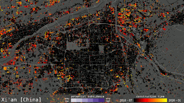
The map indicates a spatial overlap between areas developed in the past decade and zones projected to face elevated subsidence risk.
This pattern suggests that continued urban growth may be increasing the exposure of people, buildings, and infrastructure to future ground-deformation hazards.
“The platform is intended to help users better understand urban dynamics at the global scale, and we believe it could be of interest beyond the technical community,” said Cian.
“The availability of a fundamentally new dataset enables users to monitor where and when built-up areas have emerged, expanded, densified, or declined over nearly a decade.”


