A comprehensive report from Airservices Australia has unveiled insights into the future of drone operations across Australia, predicting an escalation in commercial drone flights to more than 60 million commercial flights by 2043.
In addition, a recent Australian Federal Government study estimates the expanding drone use is forecast to give a major economic boost for Australian businesses, with savings expected to be up to $10 billion. These significant cost savings for Australian businesses utilising drones will significantly impact the mining sector, followed closely by agriculture, forestry, construction and the fisheries industry.
There are now 10,000 drones currently operating commercially in Australia and each month, more than 700 people are being trained in drone operations, alongside over 100 companies gaining licences.
The use of drones in commercial applications offers several benefits when conducting land surveys, stockpile calculations, failure detection, and future planning. The most impactful benefits for businesses include increased efficiency, lower operational costs, and most importantly, improved safety for surveying teams.
Sphere Drones, one of the key players in the drone technology sector, is poised to help shape this evolution providing a full suite of drone solutions and services to assist businesses with drone adoption. The company has expertise ranging from initial Proof of Concepts, right through to scaling up remote drone programs for beyond visual line-of-sight operations (BVLOS).
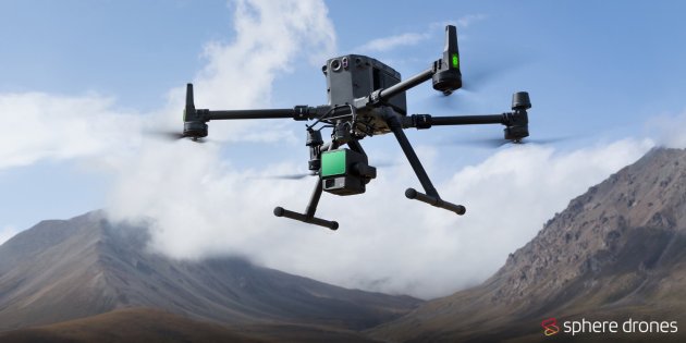
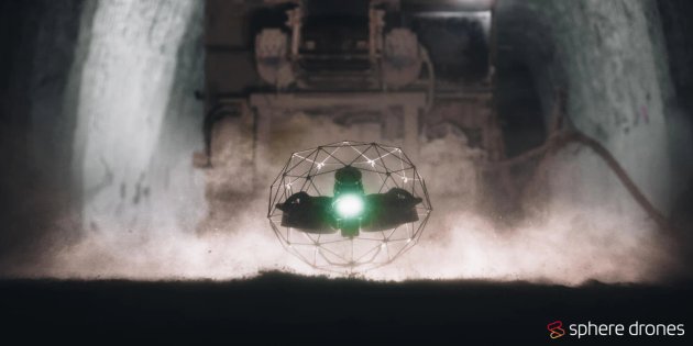
Sphere Drones’ range of surveying solutions supports outdoor, underground, and confined spaces. For outdoor use cases, solutions include the latest lineup of DJI Enterprise drones, payloads and other hardware. Their leading technologies include the Mavic 3 Enterprise, Matrice 350 RTK, Zenmuse L2, Zenmuse P1, and the newly released Dock 2. For underground and confined space use cases the Flyability Elios 3 is the leading solution, featuring LiDAR and the recently launched UT payloads.
The family-owned business is also advancing commercial use of drones through their recently launched self-sustaining mobile drone platform, HubX.
HubX enables businesses to collect aerial data with a click of a button. The patent pending, all-terrain, solar-powered and internet-enabled HubX breaks down the barriers of Drone-in-a-Box (DiaB) deployment for mine sites, land owners, utilities, and emergency services. In addition, it’s equipped within-built redundancies ensuring businesses are able to maintain uninterrupted operations in remote areas and in the event of network failures like the Optus outage in 2023.
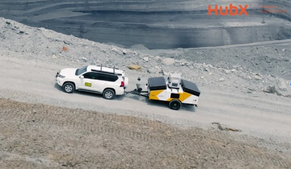
The Australian-engineered drone platform is rugged so it can cover any terrain, and is designed specifically for deployment in remote and regional areas. The turnkey nature of the mobile drone platform allows businesses to up and flying in 30 minutes of delivery to capture aerial data on-site, seamlessly delivering the data back to the office in realtime.
Sphere Drones’ CEO, Paris Cockinos, said “HubX has been developed entirely at our Sydney headquarters for use by surveyors and businesses seeking to streamline the most time-consuming surveying tasks, saving them thousands of hours and millions of dollars in the process.
“We have already attracted interest from existing and new customers in Australia and overseas looking to either complement their own operation of drones, or for Sphere Drones, being BVLOS approved, to manage their remote drone operations altogether”, he added.
High-profile customers of Sphere Drones include Yancoal, Rio Tinto, Fortescue Mining Group, Glencore, Roy Hill, Woodside Petroleum, Thiess, Sydney Water and Agriculture Victoria.
Adrian Wall, Survey Superintendent and Chief Remote Pilot at Yancoal’s Mt Thorley Warkworth mine said “with the evolution of HubX, we see its potential to streamline a surveyor’s work-load, reducing their time in the field whilst increasing data collection frequency through the automation of UAV (Unmanned Aerial Vehicle) operations.
HubX successfully trialled at Yancoal’s Mount Thorley in NSW.
“HubX includes everything you need to roll out a BVLOS (Beyond visual line of sight) operation, it’s innovative, turnkey and portable which can help businesses like ours meet their daily operational requirements”, he added.
If you are interested in learning more about BVLOS and how HubX can streamline your remote drone operations, head to Sphere Drones’ website and watch the recent HubX webinar on Breaking Down the Barriers of Remote Drone Operations.
To date, Sphere Drones has helped more than 11,000 clients, including 3,000 corporations – in the procurement or rental of drones, parts and accessories, software, and training and support for airborne and underwater drone operations.
Mr Cockinos concluded, “we provide the game-changing benefits of drone technology to save businesses costs and enable greater efficiencies for miners and other organisations.”
Want to meet the team? Sphere Drones will be at Locate24 – chat to the team about their HubX mobile drone platform, Flyability Elios 3, and all of the latest from DJI, including Dock 2 at the International Convention Centre in Sydney, from May 7th to 9th 2024.
To find out more you can visit https://spheredrones.com.au/, or reach the team on 1800 119 111 and info@spheredrones.com.au.