

PARTNER FEATURE
This is the story of the development of an intelligent positioning sensor technology, known as the Kurloo.
Did the earth move for you too? Imagine a network of sensors capable of withstanding the harshest conditions to alert you to any surface displacement or earth movement. Kurloo Technology, based in Brisbane, has transformed precise positioning technology, introducing a unique and accurate positioning-based monitoring service to the Australian and New Zealand market in 2023.
Kurloo’s precision and ingenuity
In the realm of traditional surveying, time, risk and cost have always been challenging factors, especially in high-risk and remote locations. Just over a decade ago, Kurloo’s founder, Lee Hellen, a consulting surveyor by profession, was driven by his clients’ need to find a solution that would revolutionise the industry, extending the capabilities of ground and structural movement assessment and prediction beyond anything previously thought possible.
And so commenced an extraordinary Australian-based journey of research and development that has assembled an expert team of geodetic data scientists, machine learning enthusiasts, electrical and electronics engineers and more. Their relentless efforts, backed by significant investment, led to the creation of an ingenious and intelligent positioning sensor technology, today known as Kurloo technology.
This ground-breaking positioning technology possesses the remarkable capability to make the invisible visible, detecting millimetre-precise 4-dimensional movement of critical assets and infrastructure more frequently and efficiently than ever before. Kurloo automatically alerts users to the magnitude, direction and precise timing of any displacements. Inspired by the vigilant Bush Stone Curlew, a nocturnal Australian bird commonly found in coastline across Northern Australia, Kurloo seamlessly blends into its surroundings, diligently scanning for surface displacement and promptly alerting to potential risks.
Tough Australian ingenuity
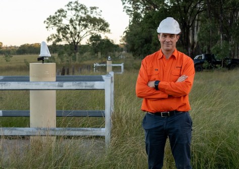
“Developing Kurloo was a genuine partnership with our Brisbane-based design and manufacturing partner IntelliDesign,” said Lee. Built to rigorous standards under an aerospace AS9100D quality system, Kurloo has undergone extensive testing in harsh Australian environments, from the snow country in Victoria to the central desert and the Queensland coastline. Lee quips, “If they can withstand the Australian climate, they can survive anywhere!”
Kurloo’s geometry and materials are carefully selected for UV stability, weatherability, high strength, optical clarity and long-term performance. Kurloo technology was recognised at the recent 2023 Asia Pacific Spatial Excellence Awards for the Port of Brisbane Seawall project.
The intelligent Kurloo device includes expandable smart sensors, simplifying management through the ‘Kurloo Nest’ Cloud. Its integral high-grade professional GNSS antenna, solar panel and rechargeable battery enable high precision and self-powered operation in low-Sun environments for up to three weeks. Onboard environmental sensors and accelerometers communicate changes and external interference, minimising errors and improving quality.
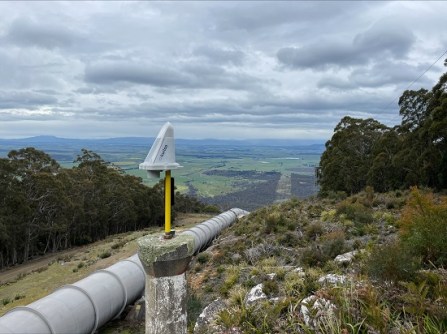
Kurloo’s unique device design supports solar operation, reflects heat, is bird-proof and resists snow and dust collection. Made with durable, UV-stable materials and sealed to IP67, Kurloo is designed to withstand harsh environments for a minimum of five years.
The Kurloo Nest is an advanced, cloud-based platform providing real-time data analysis. Accessible from any device, it sends alerts via email and SMS tailored to client specifications, delivering powerful data and reassurance.
Kurloo’s smart, flexible and affordable solutions
In the dynamic field of surveying, Kurloo has pioneered a ground-breaking ‘Hardware- and Software-as-a-Service’ offering, providing unmatched flexibility for surveyors, geotechnical engineers and construction projects. With Kurloo, you can adapt to evolving project needs, deploying Kurloos to new sites or repurposing them as required. Kurloo’s commitment to service excellence includes comprehensive management services, equipment rental, installation, training and monitoring. Seamlessly integrating Kurloo empowers surveyors, engineers and project managers to revolutionise their approach and improve processes. Embrace the limitless possibilities Kurloo brings to surveying and geospatial industries, free from the constraints of traditional methods.
Kurloo and the Port of Brisbane: A case study
In the pursuit of enhancing remote operation capabilities, the Port of Brisbane made a game-changing decision — to add Kurloo technology to its Seawall project. Daniel Burley, Head of Infrastructure at the Port, enthusiastically expressed that “Kurloo is providing the possibility of further empowering remote operation capability at the Port, with safer, more consistent, and frequent measurements. It delivers insights we can act on quicker than ever before, all with the confidence that the data is accurate. We’ve been pleasantly surprised by how effortless it is to install and operate Kurloo, thanks to the user-friendly Kurloo Nest platform.”
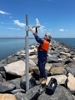
The deployment of Kurloo units along the Port of Brisbane seawall has been a transformative move, especially in monitoring movement and land reclamation areas to observe settlement patterns. Leveraging the power of GNSS technology, the equipment operates remotely, providing daily feedback on the stability of the rock during and after placement. This invaluable data empowers contractors with greater certainty that the works are performing as expected, resulting in minimal re-work and significantly reducing the risk of equipment loss and contamination of the adjacent Moreton Bay Marine Park.
The Port of Brisbane’s adoption of Kurloo serves as a shining example of how this innovative solution revolutionises remote operations and delivers tangible benefits.
Unlocking Kurloo’s competitive edge: Transforming workplace safety and efficiency
Kurloo is a game-changer in workplace health and safety, addressing safety concerns and reducing time and financial costs associated with site shutdowns. Its suitability for high-risk environments makes it invaluable, providing insights without compromising safety. In remote locations like the Tasmanian wilderness, Kurloo drastically reduces time and cost barriers for surveying work. It also plays a vital role in preserving heritage sites and enables real-time monitoring of surface displacement, mitigating risks and ensuring preservation. Kurloo’s versatility extends to various sectors and disaster-prone regions, offering early detection and response capabilities.
Unveiling the hidden costs: Mitigating disasters with Kurloo’s data-driven approach
The cost of disasters, both financially and in terms of human lives, is significant. Kurloo empowers professionals to revolutionise disaster mitigation by providing the right facts, information and skills. With improved data science, Kurloo equips engineers with the tools to proactively monitor and analyse data, mitigating safety risks and averting major failures. Its simplicity and scalability make it easy to integrate into existing workflows, providing real-time data for informed decisions and proactive measures to prevent disasters.
AI and machine learning: Pioneering life-saving innovation
Kurloo’s journey towards innovation has some exciting possibilities. Lee said, “In the next two years, our vision is to achieve something extraordinary — predicting engineering and environmental disasters before they strike”. With the immense potential of machine learning and artificial intelligence, Kurloo aims to harness the power of data to identify and predict these catastrophic events, potentially saving countless lives.
“Imagine a future where quantitative data seamlessly integrates with emergency systems, providing real-time insights that enable swift and effective response measures. Kurloo is committed to making this vision a reality, pushing the boundaries of what is possible and revolutionising the way we safeguard our communities,” said Lee.
But Kurloo’s impact reaches far beyond disaster prevention. “We envision further advancements in Kurloo Technology for scientific and research applications, opening doors to unprecedented possibilities in precise positioning,” said Lee. “By making this technology more accessible, we are fostering an environment that nurtures scientific discovery and unlocks new knowledge.”
“Moreover, collaboration holds immense potential in enhancing accessibility to positioning infrastructure, particularly in the developing world. By working together, we can bridge the gaps, democratise access to innovative solutions, and empower individuals and communities worldwide.”
Kurloo enables professionals to perceive the world with precision, empowering them to make smarter, data-driven business decisions. If you’re ready to embrace a future where technology transforms the way you manage your project sites, we invite you to connect with the Kurloo team today. Reach out to us at sales@kurloo.io and discover how Kurloo can reshape your approach to surveying, engineering and geospatial solutions.
Embracing a future where Kurloos tirelessly keep watch, ready to raise an alert of any surface or infrastructure movement, Lee and his team have embarked on a ground-breaking journey of innovation with a vision to create a safer world without limits.
For more details about mobilising Kurloo for your project across Australia and New Zealand, visit www.kurloo.io or email sales@kurloo.io.


