


A new reference guide from ESRI Press will help overcome problems in aligning disparate map projections with GIS technology. Designed for beginning and advanced ArcGIS practitioners, Lining UpData in ArcGIS: A Guide to Map Projections offers techniques for identifying and creating accurate map projections and co-ordinate systems. The content ranges from procedures to identify […]
Search results for "ArcGIS"

Locate24 Vendor Focus: 1Spatial
In the run up to the Locate conference in May, we’re highlighting some of the companies you’ll be able to meet.

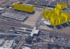
City of Sydney: Growing green with GIS
The City of Sydney has set targets to grow a cooler, more diverse, and resilient city using mapping technology.
NSW Spatial Digital Twin delivering a smarter future
Without a spatial digital twin, there can be no smart cities, no smart regions and no smart states.

Interview: David Robinson, Onneer
In our annual Leaders Forum, we ask the experts to look ahead into 2024. Today we talk GIS with David Robinson.
Software for integrating field data
Trimble has released the Trimble Terra Office add-in for Esri ArcGIS Pro, a new product for integrating Trimble TerraFlex field data collection software with GIS systems of record.

Canberra selects ICEYE for disaster data
The federal government has selected ICEYE to supply flood and bushfire data for all states and territories.

NZ elevation project more than 50% complete
The release of 3D mapping data for Waikato and Southland means more than half of New Zealand is covered.
US agencies to give access to Antarctic, Arctic DEMs
A new agreement will provide continued public access to historical and new digital elevation models.

GNSS solutions for subsurface asset mapping
GNSS technology can unlock solutions for subsurface asset mapping while improving efficiency and accuracy.


