

PARTNER FEATURE
GNSS technology can unlock solutions for subsurface asset mapping while improving efficiency and accuracy.
By Peter Terrett
The mapping of sub-surface utility assets such as water, gas, electricity and telco networks, has been a critical task for infrastructure planning and maintenance for decades. Mapping is essential to ensure the safety of construction workers, avoid service disruptions and prevent damage to infrastructure.
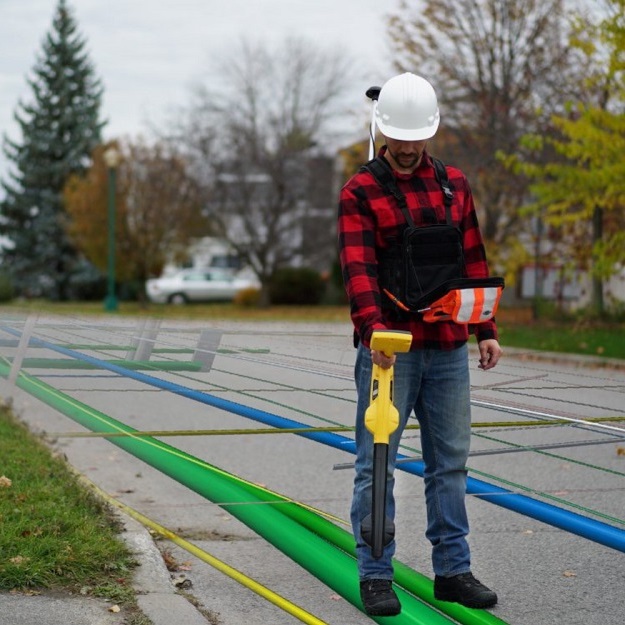
In the past, subsurface utility assets were not often mapped accurately in a coordinate system. It would have been expensive to engage a surveyor with specialist knowledge and equipment. Instead, the centreline of a pipe or cable would have been measured as a distance from fence corners, property boundaries, kerbs, power poles and so on. Thankfully, there are now other solutions, such as radio detection, magnetic locators, metal detectors, high frequency microwave and acoustic systems, to aid the skilled utility locator find most of the assets.
But recent innovations have now made it possible for non-survey-qualified operators to accurately map subsurface assets. Some training is required because, although the equipment can be straightforward, different correction services may result in different datums. This means that although you may have high precision, your actual coordinate may be in a different location to your asset management system or GIS.
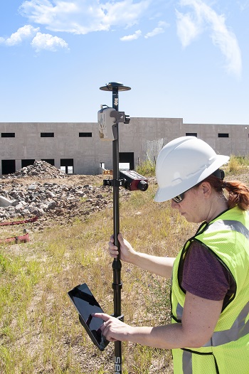
GNSS technology has emerged as a powerful tool for mapping these assets accurately and efficiently. In particular, smaller, higher performing, more accurate and lighter receivers are now available that are easy to use. Recent enhancements include moving from GPS alone (one constellation) to GNSS (four or more constellations), dramatically increasing performance and accuracy, particularly in harsh environments. Where GPS alone averaged nine satellites in view, GNSS can average more than 40, thereby increasing the geometric strength of the position solution. Also, as mobile phone coverage has increased, GNSS users now have increased access to CORSNet in many more locations.
Enhanced GNSS receivers such as the Eos-GNSS Arrow (available from 4D Global) can now access the new Australian/New Zealand Satellite Based Augmentation System, known as SouthPAN. SouthPAN provides Australia and New Zealand wide sub-metre accuracy for free for compatible L1 (single frequency) and multi-frequency receivers. Not all receivers can currently use SouthPAN, and those that can will require their configuration to be set up correctly to use the service. Ultimately there will be three services levels available down to 100 mm for an L1, L5 compatible receiver. Eos-GNSS units are also designed for Esri field-mapping solutions out of the box to save time for utilities that use ArcGIS for their corporate GIS.
Whether your goal is to map for spatial asset management, ISO55000 or AS 5548.1 classifications or locating for water and gas utilities, another innovation to improve your GIS data in the field is to use a radio detection system for locating subsurface metal pipes and have the location data passed straight through to the mapping software with accurate GNSS coordinates.
The major advantage of using GNSS technology is efficiency. GNSS enables field technicians to map assets quickly to reduce time and cost. This is especially important for infrastructure planning, design, construction, digital twin foundational datasets and asset maintenance, where accurate and up-to-date mapping data is essential.
GNSS technology has emerged as a powerful tool for mapping sub-surface utility assets. However, challenges such as urban canyons or vegetated environments need to be addressed to ensure the quality and reliability of the data. To ensure you get the results you need, consult an experienced GNSS solutions supplier to ensure that your equipment is set up correctly right at the start of your project.
4D Global’s Peter Terrett has more than 35 years of experience in providing space-based positioning solutions.
To learn how GNSS can save you time and take your subsurface mapping to the next level, contact Peter Terrett at pterrett@4dglobal.com.au or 0419 30 7770.


