

Land Tasmania has announced that development of the new LISTmap is progressing towards a November 2026 completion.
The acronym LIST stands Land Information System Tasmania, which is an online service that provides access to integrated land and property information.
LIST is used by a wide variety of professionals, such as surveyors, real estate agents, valuers, financial institutions, solicitors, natural resource managers, planners, and people employed in mining, forestry and agricultural industries.
LISTmap itself is a service that enables users to view and create maps using data from numerous official datasets, such as those covering natural resources, roads, community facilities, the cadastre and aerial imagery.
Although it takes its data from official sources, LISTmap displays are indicative only and cannot be used, for instance, for establishing true location boundaries. For that, proper surveying is required.
New features
In September last year, Land Tasmania and development partner Geometry Pty Ltd delivered the first version of the new LISTmap platform for internal review and refinement.
That version verified the platform’s key IT infrastructure and design features and is forming the basis for ongoing development.
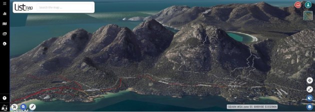
The search, layer management, bookmarks, markup tools and printing functions are being enhanced, while new features include mobile phone functionality, the ability for users to create their own dashboards to save LISTmap activities, and viewing and navigating in 3D.
It is expected that the next major internal release will occur in July 2026, with awareness, testing and training activities continuing for key users until November.
LISTmap and the associated Common Operating Picture provide access to more than 3,200 spatial datasets covering Tasmania, e.g. natural resources, roads, agricultural enterprise suitability, community facilities, property boundaries, aerial imagery and survey information.
More than 1,950 datasets are specifically used for managing emergencies and incidents in sectors such as power, water, sewerage, the environment and heritage sites.


