

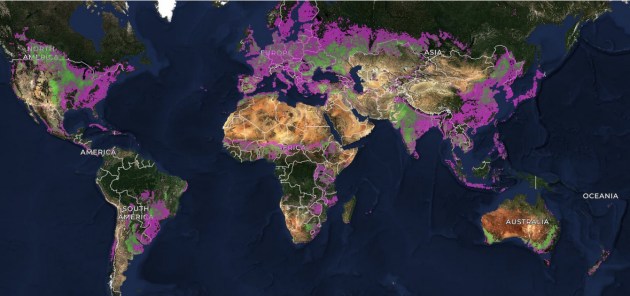
Taylor Geospatial has released what it claims is a map of the boundaries of every agricultural field on Earth.
The data from the effort, funded by Taylor Geospatial and co-developed with Microsoft AI for Good Lab, has been made publicly available.
In a statement, the non-profit research organisation called the development “one of the most ambitious GeoAI efforts we know of — because we believe GeoAI should work everywhere, not just in the data-rich regions where labelled training data is abundant”.
Taylor Geospatial says that knowing the locations and extent of agricultural fields is vital for applications such as precision agriculture, food security monitoring, carbon accounting and climate adaptation planning.
But previously, a global map of such fields has not been available.
Novel model
To tackle the problem, the organisation put together a team of researchers and technologists and got the Microsoft AI for Good Lab in as a co-investor.
Taylor Geospatial says it developed a novel model and model architecture specifically designed to infer field boundaries at global scale, including an extensive training dataset.
The effort required significant cloud computing infrastructure in order to make that global-scale inference possible.
The team had to solve problems in the data diversity, compute scale and model generalisation inherent in dealing with wildly different agricultural landscapes across the planet.
The effort was boosted with contributions from and collaborations with experts at Arizona State University and Washington University, Clark University, Source Cooperative (which hosted cloud-native geospatial datasets), Wherobots (which built the RasterFlow platform and generated the global mosaics), and a team of Taylor Geospatial Technical Fellows.
Mixed reception
The announcement has been met with both praise and some reservations.
One person, commenting on LinkedIn, called it a “remarkable achievement,” saying that “What this dataset does that no other has done: it shifts the unit of analysis from the pixel to the field. That is the natural unit of agriculture. And doing so for two consecutive years makes change detection possible for the first time.”
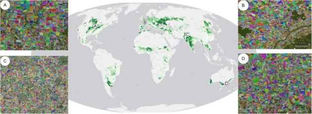
But another person commenting on LinkedIn said that “there remains quite a bit to go before it will be truly a ‘global map of field boundaries’.”
“Where I live in eastern Ecuador, no fields are shown whatsoever. And in some places where I used to live in Finland and Sweden, many fields are missing, at a fast glance I would estimate about 25% of the area,” he said.
“In Norway, again, almost as bad as in eastern Ecuador. It seems to work well only in landscapes heavily dominated by agriculture, but not where agricultural fields are interspersed with other types of land use and vegetation.”
Openly available
Taylor Geospatial says it is partnering with NASA Harvest, the Food and Agriculture Organization of the United Nations (FAO) and other global and regional partners to put distribute the dataset to food security analysts, climate researchers and agricultural development organisations worldwide.
“Over the past few months, we’ve been running the algorithm at a global scale and making it accessible to a wide range of users,” said Nathan Jacobs, a member of the team and assistant vice provost for digital transformation and director of the Multimodal Vision Research Lab at Washington University.
The model, Practical Recipe for Field Boundary Segmentation at Scale (PRUE), has been published in a preprint for the IEEE/CVF Computer Vision and Pattern Recognition Conference to be held in June 2026.
The model code is available on GitHub.
And a paper on the global field boundaries at 10m resolution, describing how confidence in the model was evaluated, has been published.


