


The collaboration will deliver a mobile solution that enables the visualisation of buried infrastructure.
Search results for "asset management"

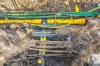
GNSS solutions for subsurface asset mapping
GNSS technology can unlock solutions for subsurface asset mapping while improving efficiency and accuracy.

GNSS for subsurface asset mapping
Mapping underground utilities such as water, gas, electricity, and telecommunications networks has been a key task in infrastructure planning and maintenance for decades. Mapping is essential to ensure the safety of construction workers, avoid business interruption and prevent damage to infrastructure.
UK to build Underground Asset Register
The digital map of pipes and cables will boost construction and development and improve worker safety.

Urban Tree Canopy Management and Change Detection using LiDAR
DR. SAMUEL HOLT, RESEARCH & DEVELOPMENT, AEROMETREX The urban environmental crisis Cities globally face many environmental challenges and governments at every level are placing great emphasis on developing environmentally sustainable urban areas. Scientific studies have shown that the presence of trees in urban areas has a wide range of positive economic, social, and environmental effects. […]

Victoria launches digital asset infrastructure strategy
Strategic plan mandates DE and BIM across entire infrastructure asset lifecycle.
Provision of Drainage Asset Inventory Data Collection
Penrith City Council is seeking proposals for the reliable and cost effective provision of collecting inventory data and undertake visual assessments of the condition of pits and pipes drainage assets within its Peachtree and Lower Surveyor Creeks Catchment. The purpose of this Request for Tender is to seek the services of Suppliers to produce a […]
Read full story • Comments are closed

Leica releases mobile asset monitoring solution
Leica has released Jasset, a monitoring solution that locates mobile and semi mobile assets.

Bentley AssetWise APM v7.2 announced
v7.2 allows infrastructure assets to be viewed in the context of engineering information.
ANZ Disaster and Emergency Management Conference call for abstracts
The Australian & New Zealand Disaster and Emergency Management Conference will provide a forum to examine the issues surrounding natural and man-made hazards. The program will focus on Prevention, Preparedness, Response & Recovery, and will include keynote addresses, concurrent sessions, and workshops covering human and social issues, economic and environmental challenges, infrastructure, community and communication […]