

Image credit: ©stock.adobe.com/au/creativenature.nl
The UK’s Ordnance Survey (OS) has announced it will work with engineering and project-management consultancy Atkins to build a National Underground Asset Register (NUAR) for the UK.
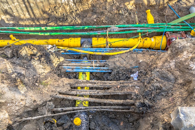
The new digital map of underground pipes and cables will help improve efficiencies in construction and development, reduce disruption and improve workers’ safety.
The location-enabled service will provide fast access to network data, saving utilities companies and local authorities time and money, and reducing the disruption caused in trying to fix leaks and putting in new infrastructure.
“We are delighted to be part of this exciting transformative project,” said Ordnance Survey’s Head of Geospatial Solutions, Chris Tagg.
“The development of a UK wide underground digital map of the nation’s utilities has been an innovation focus for OS for several years and it is great that the National Underground Asset Register is now entering the build phase.
“We are looking forward to working with Atkins, 1Spatial and the other partners on the build and sharing our world leading geospatial data, as well as our know how and learnings from supporting customers across the utility sector for many years.”
The digital map will be built over the next three years, starting in the North East of England, Wales and London.
Atkins has been appointed by the UK Government’s Geospatial Commission to help create the digital map of underground pipes and cables. The company will work with OS, 1Spatial and other partners to deliver the build phase of the project to create a ground-breaking nationwide geospatial platform to view all underground asset data, helping to tackle the £2.4bn in lost value to the economy each year from accidental utility strikes.
OS has recently been a member of a consortium, with utility companies and local authorities in the UK’s North East, developing a digital data exchange platform as part of one of the Geospatial Commissions NUAR pilot projects.
The platform, underpinned by geospatial data, enabled any of the participating organisations to see an integrated, common and consistent map view of the underground assets in the location they are looking to excavate, with the most crucial operational information available, on a single device.
“The response from users on the pilot project in the North East was overwhelmingly positive, and the predicted impact for national implementation is huge,” said Tagg.
Stay up to date by getting stories like this delivered to your inbox.
Sign up to receive our free weekly Spatial Source newsletter.


