

The New Zealand Government has tipped in an additional $529,000 (NZ$641,000) for a 3D LiDAR mapping project in Otago.
The extra funding comes on top of $987,000 (NZ$1.2 million) allocated to the Otago Regional Council in December last year. At that time, 3D LiDAR data covered only 28% of the region.
The boost — which take’s the Government’s funding share of the project to 63% — will mean the Council will achieve full coverage of the area by 2027–28.
“LiDAR is a critical tool for understanding our landscape and using the data to prepare for future challenges, from flood risk and natural hazards through to climate adaptation and infrastructure planning,” said Councillor Gretchen Robertson, Science and Resilience Portfolio Co-Lead.
“The funding recognises the importance of high-quality data and the data this work provides will benefit Otago for decades to come.”
A complete, high-quality elevation dataset
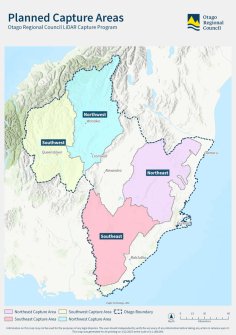
At the moment, approximately 32% of the Otago region has been covered by the 3D LiDAR project, an area of about 10,200 square kilometres.
This includes Dunedin, the coastline from the Waitaki River to the Catlins, parts of the Central Otago and Queenstown Lakes districts, and sections of the Clutha and Waitaki river catchments.
The program aims to capture data over a further 23,000 square kilometres.
Science and Resilience Portfolio Co-Lead, Councillor Gary Kelliher, said the data will be freely available via the LiDAR Data Service to businesses, landowners, and infrastructure providers, ensuring the benefits extend well beyond council.
“Reaching this milestone means Otago will soon have a complete, high-quality elevation dataset across the entire region,” he said.
“That creates lasting value for everyone who relies on accurate information about our landscapes, rivers, and coastlines.”
The first datasets for the Queenstown-Lakes District are expected to be available publicly from late 2026, with others to follow in 2027.
Related news:
Four-year LiDAR mapping project completed
LINZ begins 3D LiDAR mapping of NZ’s coastline


