Toitū Te Whenua Land Information New Zealand (LINZ) is in the process of 3D LiDAR mapping large stretches of New Zealand’s coastline.
The high-definition 3D Coastal Mapping program will be particularly useful for understanding parts of the nation’s coastline that are vulnerable to the effects of climate change.
“As a small island nation New Zealanders living and working near the coast are exposed to climate events and natural hazards like tsunami, and these will impact valuable infrastructure, environmental and cultural assets close to the sea, as well as coastal biodiversity,” said Stuart Caie, 3D Coastal Mapping Programme Lead at LINZ.
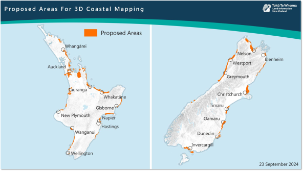
Two companies have been contracted to collect the aerial LiDAR data: Woolpert NZ for the North Island and NV5 Geospatial for the South Island. The aircraft will fly at an altitude of about 500 metres.
Areas to be mapped this summer include coastlines in Gisborne, Bay of Plenty, Taranaki, Manawatu-Whanganui, Hawke’s Bay, Wellington, Oamaru, Timaru, Dunedin, Southland and Westland.
“Coastal mapping data is used by scientists and environmental planners to better understand how the country may be impacted and help keep communities and infrastructure safe, as well as protect ocean biodiversity through improved habitat mapping,” said Caie.
The project will produce baseline data for up to 40% of the nation’s coastline over the next three years. Once processed, the data will be made freely available on the LINZ Data Service website and the LINZ Basemaps service.
“As we’ve seen with other LiDAR data on land, the coastal data can be used to assess changes to the coast through erosion or subsidence, build-up of dirt and debris from cyclones or weather events, and land uplifting from earthquakes,” said Caie.
“We know scientists are excited about this data and the modelling that it can enable, especially as storm surges are likely to become more frequent as sea-level rises in the future.
To understand the extent of sea-level rise, LINZ has begun installing GPS at sea-level gauges to measure changes in the vertical movement of the land. When coupled with the sea-level gauge data, the information will enable researchers to measure the effect of sea-level rise over time.