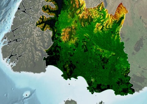
A four-year project to deliver 3D, high-resolution LiDAR mapping of New Zealand’s Murihiku Southland region, has been completed.
Environment Southland’s General Manager Strategy, Policy and Science, Rachael Millar, said the digital elevation and digital surface models are now available and are already providing significant benefits to a wide range of users.
The region’s previous elevation maps had contours down to only 8 metres resolution, whereas the new data is available at 1 metre resolution for rural areas and down to 20 cm for some urban areas.
The project, which was partly co-funded by four Southland region councils, has involved thousands of hours of data collection, processing and checking.
“The region hasn’t had a tool before that provides such detail and it is going to be particularly useful in planning for Southland’s future,” said Millar.
“The [Southland Regional] Council will use it for flood modelling, coastal inundation mapping and to help with farm planning, to name a few.”
The data is also already being used for:
- Hazard planning
- Infrastructure planning and policy development
- Understanding landscape changes
- Understanding catchments’ hydrological processes such as stream flow estimation and catchment size.
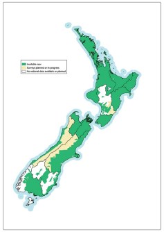
Murihiku Southland is one of 10 regions that partnered with Toitū Te Whenua Land Information New Zealand (LINZ) to obtain the baseline elevation data set.
Co-funding between Southland’s four councils and the Ministry of Business, Innovation and Employment Kānoa Provincial Growth Fund supported the regional expansion of LINZ’s 3D mapping program to provide a significant increase in national coverage.
The Southland data can be accessed in processed form in the following web applications, accessible from the Environment Southland Beacon service:
- Southland Contours and Elevation (for heights and using contour lines)
- Southland 3D Map and Profile Tool (for profile tool and visualising)
Data covering about 70% of the country is available at the LINZ Data Service, with another 10% to be added over the next few months, which will complete the project.