The Victorian Department of Transport and Planning’s Geodesy team has completed a large-scale airborne gravity survey across the south and east of the state.
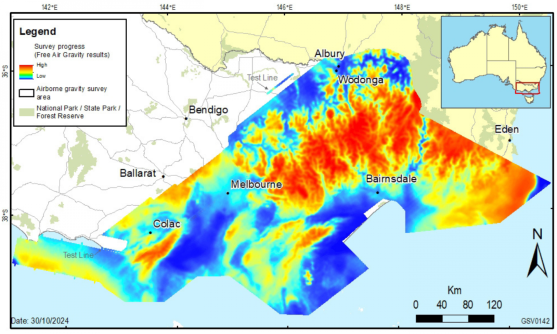
Conducted from 2022 to 2024, the survey collected consistent and evenly distributed gravity measurements across Melbourne, the Australian Alps, eastern Victoria, and the coast from Cape Bridgewater to Cape Howe.
The resulting survey comprises the largest airborne gravity dataset ever collected in Victoria, including hard-to-access areas that previously had had little data coverage.
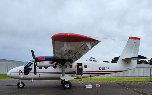
The survey employed experienced pilots and two small, fixed-wing aircraft (Twin Otters) from Sander Geophysics. Each aircraft carried sensitive gravity-sensing instruments to measure extremely small variations in the Earth’s gravitational field due to the varying terrain and geology below.
The pilots had to fly precise routes spaced either 500 metres, 1 kilometre or 2 kilometres apart, eventually racking up 197,217 kilometres of flight lines.
Because the aircraft had to fly very low (150 metres altitude over rural areas and 300 metres over built-up areas), the work could only be conducted in favourable weather.
The area covered was around 150,000 square kilometres, or two thirds of the state.
Read our full feature article from earlier this year about the Victorian airborne gravity survey.
When integrated with previously captured airborne — coastal Gippsland (2011), south-west Victoria (2019) and Bendigo (2004, 2019) — and land survey gravity datasets, the new data will improve gravity models used in GPS devices to obtain heights to an accuracy of a few centimetres.
The data will be employed by governments and other users to manage Earth resources, infrastructure and natural hazards.
It will also benefit a variety of applications in the precise positioning field, such as surveying and mapping, construction, water and environmental management, transport and precision agriculture.
The project was organised and accomplished together with the Victorian Department of Environment, Energy and Climate Action’s Geological Survey of Victoria and Geoscience Australia.
Earlier this year, NSW DCS Spatial Services announced the completion of Australia’s first statewide airborne gravity model, covering more than 800,000 square kilometres of NSW and the ACT.