

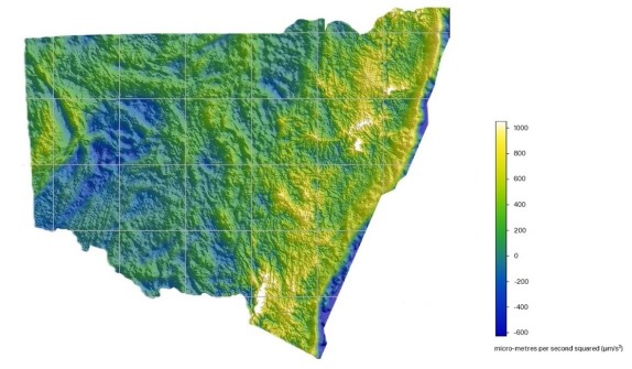
NSW DCS Spatial Services has announced the completion of Australia’s first statewide Airborne Gravity Model, which it says, will be a “game changer” that provides detailed insights into Earth’s architecture while delivering significant time and cost savings for NSW.
The Model covers more than 800,000 square kilometres of NSW and the ACT, including 50 kilometres off the NSW coastline.
“The Gravity Model Project positions NSW as a leader in airborne gravity data coverage in Australia and will not only benefit various industries but also unlock investment opportunities, create jobs, and potentially drive economic growth throughout the State particularly in construction and mining,” said Thomas Grinter, NSW Deputy Surveyor General.
Preliminary data is now available at:
When combined with other existing datasets, the Model will improve the ability to:
- Prepare for natural disasters
- Identify critical mineral deposits
- Locate groundwater resources
- Develop infrastructure, including new housing
According to the NSW Government, “The future global economy and the pathway to lower emissions will be founded on minerals that NSW is rich in, such as cobalt, rare earth elements and copper”.
“As demand for these minerals continues to rise, the need for responsible sourcing and development becomes more urgent. Supported by Gravity Model data, NSW, with its abundance of these minerals, has a unique opportunity to meet this demand and play a significant role in the transition to a low-emissions economy.”
Importantly for the geospatial sector, the Model supports accurate height and spatial determination, which will be of great benefit to the construction and surveying industries — productivity benefits are estimated to exceed $59 million over the next decade.
The Model has been produced with the support and expertise of the Geological Survey of NSW (NSW Department of Primary Industries and Regional Development) and Geoscience Australia.
DCS Spatial Service says it will continue to process and refine the Model’s data, with value added products set for release through MinView within the next few months. Once complete it will be freely available from the Geological Survey of NSW.


