

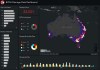
WA’s Advanced Spatial Digital Twin will see an entire third of the continent replicated in spatially accurate 4D.
Search results for "asset management"
BYDA calls for better data to reduce utility strikes
Before You Dig Australia says new data standards and a digital asset register could save $782 million annually.

Satellite-based SAR for infrastructure monitoring
New research aims to improve the inspection of roads, retaining walls and embankments from space.

Spatial WA: The plan to digitise an entire state
WA’s Advanced Spatial Digital Twin will see an entire third of the continent replicated in spatially accurate 4D.

Curtin’s GNSS-SPAN team boosts orbit accuracy
Newly developed algorithms use links between satellites to precisely determine a CubeSat’s position.
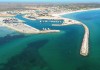
More WA harbour channel dredging to commence
Exmouth’s harbour entrance is to be dredged after a hydrographic survey showed substantial channel narrowing.
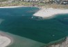
Hydrographic survey reveals river mouth narrowing
The mouth of the Murchison River is being dredged after the channel width was shown to have more than halved.
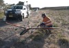
Carbonix flight milestone for SA Power Networks
The Australian-made Volanti UAV conducted a BVLOS inspection of 150 km of powerlines.

$140 million allocated for WA Spatial Digital Twin
The 10-year project aims to improve infrastructure delivery, land use and emergency preparedness.

360 Panorama Solution for Safer Roadside Assessments and As Built Validation
RapidMap now offers the Smart Street 360 which is a rapid deployment panorama camera capture GNSS solution to create personalised Spatially accurate Street Views efficiently. Ideal for Local Government, use for roadside assessments pre and post disaster or simply to record the current condition of shared paths, sealed and unsealed roads.
Read full story • Comments are closed