


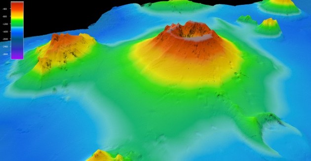
Researchers aboard the CSIRO’s research vessel RV Investigator have mapped the seafloor around the Hunga Volcano near Tonga, which erupted spectacularly in 2022.
The 54-day exploratory journey saw the team, led by University of Tasmania scientists, use bathymetric methods to map the seafloor, finding that the ‘eruption of the century’ spread deposits more than 80 kilometres in all directions.
It also blasted an ash column 58 kilometres into the atmosphere and severed undersea telecommunication cables, cutting Tonga off from the rest of the world for week.
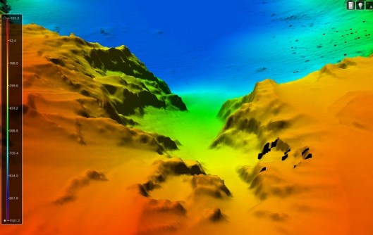
“The mapping we completed was extensive and CSIRO mapping experts on board were even able to produce an incredible, first-person view of the volcano as if you were standing on the caldera floor,” said voyage Chief Scientist, Associate Professor Rebecca Carey from the University of Tasmania’s Centre for Ore Deposit and Earth Sciences.
Upgraded deep sea tech
Because technology has advanced significantly since the RV Investigator was commissioned in 2014, its suite of acoustic systems was upgraded last year in order to maintain its state-of-the-art capabilities.
In particular, the multibeam echosounder (MBES) upgrades involved the installation of three new Kongsberg systems in the vessel’s gondola:
- The deep-water Kongsberg EM 124 operating at 12 kHz and 1° x 1° beam footprint, with a mapping depth range to 11,000 metres (full ocean depth);
- The mid-water Kongsberg EM 712 operating at frequencies in the 40-100 kHz range and 0.5° x 1° beam footprint, with a mapping depth range to 2,000 metres; and
- The shallow-water Kongsberg EM 2040 MKII with an operating frequency range of 200 to 700 kHz and 0.4° x 0.7° beam footprint, capable of mapping to 200 metres water depth.
The new systems were compatible with the existing vessel infrastructure, reducing complexity for the upgrade integration and building on existing team knowledge and system familiarity.
In addition to increasing operating depth for mid- and shallow-water surveys, the new systems are delivering a broad range of increased functionality including:
- Improved swath coverage and higher-resolution data from a greater number of individual beams;
- Enhanced small object detection in shallower waters for the EM 2040 MKII; and
- Generally lower system noise, resulting in superior data of increased resolution that requires less post-processing.
An additional change made during the upgrade was to permanently mount the EM 2040 MKII in the vessel’s gondola, providing this capability on every voyage.
Prior to this, the previous shallow-water MBES system was attached to one of the vessel’s scientific drop keels when requested for research.
Clear and present danger
The 2022 eruption weakened the Hunga Volcano, with its steep slopes becoming potentially unstable and subject to erosion and collapse.
This has raised concerns that those slopes could one day detach and fall, resulting in damaging tsunamis.
“We have generated data products that will support these hazard assessments, inform risk models and guide recovery planning,” Associate Professor Carey said.
“This research will help build and strengthen resilience and preparedness in the region for future volcanic events, and we look forward to sharing our findings and data sets collected during the voyage with Tongan agencies, the Australian government, and our regional partners.”
“In addition to volcanic hazards, the new seafloor maps reveal that Tonga is also vulnerable to submarine landslides,” added Mele Manu, Chief Geologist at the Tonga Geological Services.
“These can occur due to the steep seamounts on the seafloor and the frequent earthquakes in our region.”
“Such events could trigger local tsunamis and damage vital underwater infrastructure such as submarine cables,” said Manu.
“This highlights the importance of strengthening our monitoring and early warning systems to better protect both our coastal communities and national infrastructure.”
The team included scientists from Australia, Tonga, Fiji, New Zealand, the UK and the US.
The research was supported by a grant of sea time aboard RV Investigator from Australia’s Marine National Facility, which is funded by the Australian Government and operated by CSIRO.


