


The NISAR (NASA-ISRO Synthetic Aperture Radar) Earth-observing radar satellite, launched in July, is on track to begin its science collection phase this month.
Early images have revealed the satellite’s imaging strengths, providing detailed views of various locations on Earth.
In one of the images, of Mount Desert Island in Maine, forested areas can be clearly distinguished from harder surfaces such as open ground and buildings.
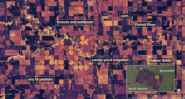
Another image shows farmland in North Dakota, with farming plots, a river and forests easily identifiable.

NISAR carries two radars:
- A NASA L-band, side-looking, fully polarimetric, interferometric L-SAR supplied by JPL that operates at a wavelength of 24 cm. The plan is for the instrument to be active while collecting data for 45 to 50% of each orbit on average, but with peaks as high as 70%.
- An ISRO S-band system that operates at 10 cm wavelength, and which comprises 48 S-band transmit/receive array elements in two rows (24 per polarisation).
According to NASA, the L-band system can “penetrate forest canopies and measure soil moisture and motion of ice surfaces and land down to fractions of an inch, which is a key measurement in understanding how the land surface moves before, during, and after earthquakes, volcanic eruptions and landslides”.
The S-band radar, supplied by India’s ISRO, “is more sensitive to small vegetation, making it effective at monitoring certain types of agriculture and grassland ecosystems”.
Both radars are array-fed reflectors working as SweepSAR, scan-on-receive, wide-swath mapping systems.
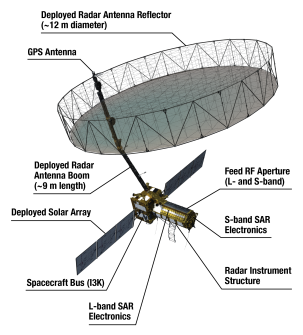
Key to the spacecraft’s success is its very large, 12-metre-diameter dish antenna, which is used to both send and receive the radar signals. It provides a 242-kilometre-wide swath across the ground.
NISAR has a polar, Sun-synchronous, dawn-dusk orbit at an altitude of 747 kilometres, with a repeat cadence of 12 days.
NASA’s basic requirement is for the L-band system to operate for at least three years, while ISRO wants five years out of the S-band radar.
Calibration on the ice
Meanwhile, on the ground, the Australian Antarctic Division is deploying corner reflectors at multiple locations across Antarctica, Heard Island and Macquarie Island to help with calibration and validation of satellite data, including data from NISAR.
The plan involves installation of eight small reflectors on Heard Island, and four much larger ones at each of the Division’s three Antarctic stations (Mawson, Davis and Casey) as well as on Macquarie Island.
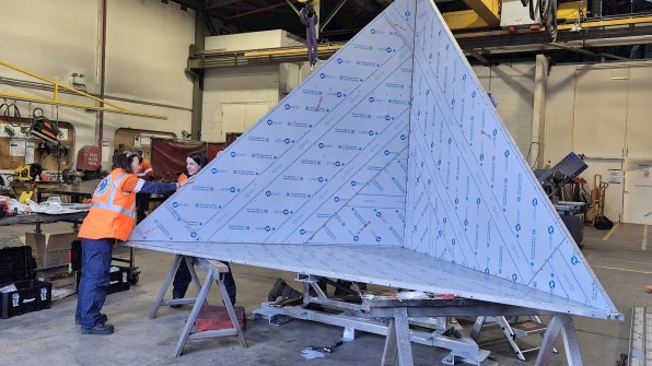
The four large, trihedral, stainless-steel reflectors were built for the Division by VerQuin Geodetic Engineering in the US; they are the largest such corner reflectors to be installed in Antarctica.
Designed to withstand winds of up to 350 km/h, they are each covered by a radome that will minimise the accumulation of snow.
While the reflectors will act as ground reference points for NISAR, they can be adapted for use with other satellites as well.


