
Australia’s spatial and surveying industry is standing at a critical regulatory crossroads is being failed by the current Automatic Mutual Recognition framework.
By Jasmine Bulman
Surveyors Australia has lodged its submission into the Review of Australia’s Mutual Recognition Scheme for workers. The submission presented to the National Competition Council (NCC) warns that the current AMR framework is failing to deliver a seamless national market.
The peak body has presented a stark warning to federal and state policymakers. Without urgent, targeted technical and legislative harmonisation, Australia’s $360 billion civil construction, property, and resource sectors face compounding project delays, escalating costs, and elevated safety risks.
Surveyors Australia is calling for an industry led, co-operative model to dismantle the complex web of state-based red tape and technical ‘shadow barriers’ that currently act as a massive tax on the nation’s surveying firms, 85% of which are small and medium enterprises (SMEs).
The cost of continued AMR inertia
Australia’s surveying sector is currently navigating a severe demographic cliff. Data from a BIS Oxford Economics (2023) capability study forecasts a peak deficit of 1,500 spatial professionals against escalating national demand.
This deficit is exacerbated by a steady 7.7% decline in licensed cadastral practitioners.
To bridge this critical gap, the industry requires an annual intake of 940 university graduates and 517 vocational graduates over the next decade.
In the short term, however, maximising the geographic mobility of the existing workforce is the only viable solution to support the delivery of national housing and infrastructure targets.
The industry requires an annual intake of 940 university graduates and 517 vocational graduates over the next decade.
The Surveyors Australia submission outlines the heavy economic stakes of continued policy inertia.
PricewaterhouseCoopers (PwC) estimated that the seamless implementation of AMR has the potential to unlock $2.4 billion in additional economic activity over ten years by enabling skilled professionals to operate across borders without duplicative licensing friction.
Furthermore, the Productivity Commission has projected that broader, targeted reforms to occupational licensing could boost national GDP by up to $10 billion.
Given that surveying serves as the critical ‘first mover’ gateway for the entire civil construction and resource sectors, failing to act on these administrative barriers carries severe, compounding national costs.
The Torrens legacy and constitutional realities
A major point of discussion within the submission is why cadastral surveying remains so deeply fragmented across state and territory lines. The peak body traces this lack of consistency directly back to Australia’s constitutional architecture and historical path dependency.
Under Section 51 of the Constitution of Australia (1900), land administration and property rights are residual powers retained entirely by the states and territories. This constitutional division is structurally bound to the Torrens Title System, a revolutionary method of land registration pioneered by Sir Robert Torrens in South South Australia in 1858, more than four decades prior to Federation.
As each colony independently established its own statutory land registry (backed today by historical legislation such as the South Australian Real Property Act 1886 and the Western Australian Transfer of Land Act 1893), geodetic networks, and local property laws to back the state-guaranteed indefeasibility of title, any mistake in a boundary survey directly compromises the state’s financial guarantee.
This connection explains why state surveying boards have historically resisted federal centralisation.
Recognising this constitutional reality, Surveyors Australia is not advocating for a blunt, centralised national licensing model. Instead, it urges the NCC to leverage existing cooperative bodies, such as the Council of Reciprocal Surveyors Boards of Australia and New Zealand (CRSBANZ) and state and territory surveyor boards, to build bilateral trust and operational equivalence on top of these state-bound legal foundations.
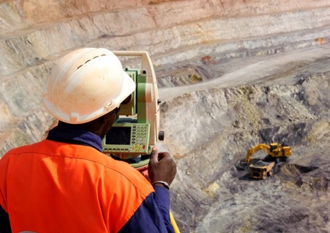
Mining surveying and the Kenner precedent: A critical safety risk
While cadastral surveying is bound to land registries, mining surveying is directly tethered to occupational health and safety.
In this high-risk discipline, a minor geometrical error can cause catastrophic hazards, including underground mine inundations, wall failures, and unintended breaches into historical, water-logged workings.
Despite these extreme safety implications, the entry benchmarks for mining surveyors across Australia are dangerously inconsistent:
- New South Wales and Queensland: State regulatory boards strictly mandate a minimum of a three-year or four-year university Bachelor’s degree, combined with exhaustive professional examinations, to practice with statutory sign-off.
- Western Australia: Under the Work Health and Safety (Mines) Regulations 2022, the state explicitly permits entry via the vocational education and training (VET) sector, accepting a three-year Advanced Diploma of Engineering and Mine Surveying as the baseline for statutory Grade 1 or Grade 2 certification.
This structural misalignment is directly linked to the landmark Kenner Report (2009), a review of Western Australia’s mine safety frameworks conducted by Industrial Relations Commissioner Stephen Kenner following a highly publicised spike in mine-site fatalities.
While Commissioner Kenner preserved the VET pathway to secure a local pipeline of technical workers for WA’s massive resources sector, he fiercely defended the necessity of independent, state-sanctioned statutory certificates of competency over corporate self-regulation.
Under the current AMR framework, this educational disparity presents an acute vulnerability. A WA practitioner holding a vocational Advanced Diploma could seek to exploit mutual recognition pathways to gain equivalent status in states that mandate a university degree, potentially triggering a ‘race to the bottom’ in educational standards.
To safeguard public safety, Surveyors Australia recommends the implementation of a national benchmark for mine surveying.
Surveyors Australia recommends the implementation of a national benchmark for mine surveying.
Rather than locking out vocational pathways, this benchmark should align statutory competencies under a national framework that mandates a standardised risk-assessment and geological curriculum.
Exposing the ‘shadow barriers’ and the CPD trap
The submission provides a detailed look at the practical, daily frustrations experienced by spatial professionals navigating the current system. Even when a surveyor is legally permitted to cross a border, they are often technically paralysed by localised directives.
The GNSS Calibration Disconnect
In New South Wales, the Surveyor-General’s Direction No. 9 mandates that if a cadastral survey is within 300 metres (urban) or 1,000 metres (rural) of the state’s official coordinate grid (the SCIMS network), the surveyor must connect their measurements to those specific physical marks.
If a Queensland practitioner crosses the border under mutual recognition, but their equipment remains calibrated to Queensland guidelines, every plan they produce will be legally invalid and rejected by NSW Land Registry Services.
The CPD Trap
To cap civil liability, eligible spatial professionals participate in the Surveyors Australia Professional Standards Scheme (PSS), which mandates five hours of risk-management training annually. But translating this training across borders is an unbillable administrative trap.
For instance, a single risk-management module is classified as ‘Survey Practice’ in NSW, falls under generic business categories in Victoria, and requires a subjective narrative (a Career Episode Report) to satisfy Queensland auditors.

Commercial paywalls on public safety
The submission also highlights that critical safety frameworks, such as Australian Standard 5488 (AS 5488) for subsurface utility engineering, act as a privatised tax on compliance. With this standard locked behind commercial paywalls, the risk of non-compliance increases, leading to catastrophic utility strikes during civil excavation.
Surveyors Australia strongly recommends making AS 5488 freely accessible, aligning with recent federal budget measures.
Actionable AMR pathways: Key policy recommendations
To resolve these systemic issues, Surveyors Australia has presented the NCC and the Council on Federal Financial Relations with eight targeted, industry led recommendations:
- Unified national board examinations: Empower state surveying boards to work collaboratively through CRSBANZ to implement a single, consistent, and locally administered board examination based on the existing National Competency Framework.
- Harmonise jurisdictional terminology: Standardise professional and paraprofessional nomenclature across states to clearly define occupational equivalence under AMR.
- Model frameworks for professional obligations: Implement unified national frameworks for Codes of Conduct, Codes of Ethics, Continuing Professional Development (CPD), and Professional Indemnity Insurance (PII).
- Leverage the hydrography precedent: Use the successful legislative recognition of Certified Practising Hydrographers across state and federal laws as the blueprint for formally recognising the Certified Engineering Surveyor (CES) framework in state procurement.
- Open-source safety rules and harmonised datasets: Remove commercial paywalls for national technical standards (like AS 5488) and standardise geodetic, GIS and GNSS datasets.
- Austroads and procurement harmonisation: Direct key federal infrastructure bodies to adopt the CES framework within their national technical specifications.
- Federated digital identity and A-SPEC standards: Fund a centralised, federated digital portal to instantly verify cross-border registration, CPD and PII status, and federally endorse unified digital data dictionaries like A-SPEC.
- National mining surveying competency benchmark: Establish a unified, national minimum safety and competency benchmark for statutory mining surveyors, bridging the gap between WA’s vocational pathway and the eastern states’ academic requirements.
By addressing these structural, technical, and educational disparities, Australia can finally build a highly mobile, safe, and efficient spatial workforce capable of meeting the nation’s ambitious infrastructure demands.
Jasmine Bulman is both Queensland State Manager and Head of Advocacy & Certification for Surveyors Australia.