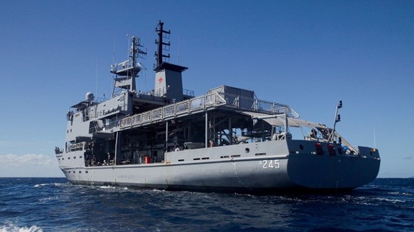
The Royal Australian Navy’s hydrographic survey ship HMAS Leeuwin has deployed to Papua New Guinea for a five-week survey mission.
HMAS Leeuwin will conduct seabed survey operations in partnership with the Papua New Guinea Defence Force (PNGDF) with the aim of assisting the PNG Government to improve the safety of maritime navigation.
“Australia and PNG have worked side-by-side in hydrographic surveying for more than 50 years, helping to chart PNG’s waters for safe maritime activity,” said Australia’s Chief of Joint Operations, Vice Admiral Justin Jones.
“This longstanding partnership is essential to maritime trade, strengthens PNG’s sovereignty, and shows Australia is a trusted partner the Pacific can count on.
“Through activities supported by the Defence Cooperation Program and the Australian Hydrographic Office, PNG continues to build its maritime capability and contribute to a peaceful, prosperous and resilient Pacific.”
Local knowledge adds to HMAS Leeuwin’s expertise
As part of the mission, Navy personnel will deliver mentoring and training for members of the PNGDF, who will themselves play a key role in the mission by contributing local knowledge.
“Embarking PNGDF personnel provides a valuable opportunity to work, learn and share knowledge together at sea,” said Commanding Officer HMAS Leeuwin, Commander Danny Finn.
“Their local knowledge enhances our understanding of PNG’s maritime environment, while together we build the skills and interoperability needed to support regional security.
“Deployments like this strengthen our professional relationships and reflect the close ties between our defence forces, other government agencies, and personnel.”
As well as the survey operations, HMAS Leeuwin will conduct defence and community engagement activities during port visits throughout PNG.
HMAS Leeuwin facts:
- Launched: 1 June 1997
- Commissioned: 27 May 2000
- Displacement: 2,205 tonnes
- Length: 71.2 metres
- Speed: 14 knots
- Range: 18,000 nautical miles
- Crew: 46
- Sonars: C-Tech CMAS 36/39, Atlas Fansweep multibeam echo sounder, and Atlas Hydrographic Deso single beam echo sounder
Changing times for the RAN’s hydrographic resources
As Spatial Source has reported in the past, the RAN’s hydrographic capabilities have been greatly reduced in recent years in favour of having survey work undertaken by civilian contractors under the HydroScheme Industry Partnership Program.
HMAS Leeuwin’s twin, HMAS Melville, was decommissioned at its homeport in Cairns on 8 August 2024.
And all four of the RAN’s Paluma-class hydrographic survey motor launches are long since gone, following the decommissioning of the last two, HMA Ships Benalla and Shepparton, on 16 June 2023.
Up until early 2024, there had been plans to build a new RAN survey vessel. A February 2020 statement released by Department of Defence said that, “With the transition of the national surveying responsibility to industry partners, the Navy survey capability is being redeveloped to focus on military environmental information collection to support Australian and allied maritime operations. The next Navy military survey vessel will be built in Henderson, WA, in the 2020s.”
But that plan was cancelled, and later in the 2024 the Defence Integrated Investment Plan was released… with no mention of a new vessel.
What it did mention was an approved commitment to spend $1 billion between 2024-25 and 2033-34 on ‘Hydrographic systems’.
That commitment comprises three arms:
- The aforementioned HydroScheme Industry Partnership Program, under which hydrographic surveying of shipping routes, the coastline and Australia’s national waters is contracted out to commercial survey companies;
- The use of Uncrewed Surface Vessels and Autonomous Underwater Vehicles for tactical and military oceanographic data collection; and
- Specialised deployable geospatial support teams that will use remote-sensing technologies and drones from warships or small craft.
According to the Royal Australian Navy, the RAN Hydrographic Service is responsible for charting more than one-eighth of the world’s surface, west to east from Cocos Island in the Indian Ocean to the Solomon Islands in the Pacific, and north to south from the equator to the Antarctic.
Further reading: