

June 21 was World Hydrography Day, and to celebrate we’re bringing you this article from the June/July 2024 issue of Position magazine.
CSIRO’s research vessel RV Investigator is delivering a keystone capability for mapping Australia’s vast marine estate.
By Amy Nau and Phil Vandenbossche, CSIRO
Australia’s scientific infrastructure received a significant boost in 2014 with the arrival and commissioning of the advanced ocean-class research vessel, RV Investigator. The 94-metre vessel, which is operated by CSIRO, Australia’s national science agency, represented a step change in Australia’s capability to conduct marine and atmospheric research across our vast marine estate by providing a flexible platform for multidisciplinary science including atmospheric, biological, geophysical and oceanographic research. Central to the vessel’s capability is a highly advanced suite of acoustic systems that enable high resolution seafloor mapping (bathymetry) to full ocean depth anywhere in Australia’s Exclusive Economic Zone (EEZ) and beyond.
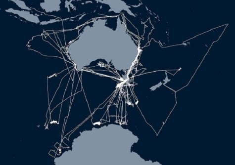
Ten years on, RV Investigator has mapped approximately 3 million square kilometres of seafloor and delivered these datasets to national and international repositories. In addition, the vessel has delivered programs of sub-seafloor mapping for national research efforts and been involved in the discovery of shipwrecks of national significance. These data have furnished our knowledge of the physical seafloor environment of our marine estate, contributing to national strategic objectives including ensuring our regional security and developing sustainable energy and resources.
During 2024, to ensure the vessel’s continued performance with the latest technologies, RV Investigator will undergo a middle of life refit. This will see its suite of acoustic systems updated to the most advanced systems available for high precision mapping of the seafloor and below. These upgrades will enhance the vessels’ capability to collect high quality and high quantity bathymetry data for the hydrographic community to further increase the benefit RV Investigator delivers to the nation and international partners.
Multibeam echosounder suite
Currently, RV Investigator has three multibeam echosounders (MBES) that operate at different discrete frequency ranges, enabling bathymetric data to be collected across the range of depths encountered within the Australian marine estate, from shallow coasts to full ocean depth.
Two of these systems are permanently fitted to the vessel in a wing-shaped gondola that is located 1.2 metres beneath the vessel’s hull: a full ocean depth Kongsberg EM 122 and mid-water Kongsberg EM 710 MK2 system. A third portable system can be fitted to one of the vessel’s two scientific drop keels: a shallow water Kongsberg EM 2040C system. This configuration reflects the vessel’s primary purpose as an ocean research vessel, providing deep sea survey and exploration capabilities, but also illustrates its flexibility in research capability, with the addition of the portable system offering greater resolution in shallow water.
The EM 122 uses the lowest frequency of 12 kHz and can map the seafloor from 20 to 11,000 metres using a 1° x 1° beam footprint. Up to 432 beams can be employed to map a swath (ribbon) approximately six times as wide as the water depth. Mapping widths of up to 30 kilometres are possible, an impressive distance when you consider the view from a ship to the horizon is around 5 kilometres. The EM 710-MK2 operates at frequencies in the 40-100 kHz range and can employ up to 400 beams to map to approximately 2,500 metre water depths using a 0.5° x 1° beam footprint.
The EM 2040C shallow water system operates between 200-400 kHz using a 1° x 1° beam footprint. This system has the flexibility to be used with either one or two transducers (dual head), which offers additional benefit in shallow waters. In dual head transducer configuration, the sonar heads are tilted approximately 35-40° either side of the vessel, greatly increasing the efficiency of surveying in shallow waters.
The MBES systems on RV Investigator are operated in combination with a Fugro Marinestar GNSS correction service for accurate measurement of the dynamic position of the vessel across varying operating conditions. Centimetre-level range accuracies are achievable in shallow water and highest-level accuracies to full ocean depth.
Hydrographic expertise
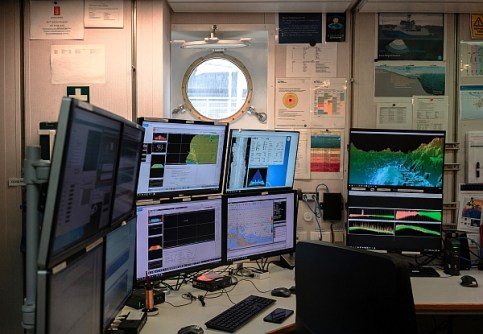
Operating the suite of MBES systems on RV Investigator are highly skilled specialists from CSIRO’s Geophysical Survey and Mapping (GSM) team. This team is responsible for managing data collection, storage and quality assurance. Importantly for a multidisciplinary research vessel, this team is also responsible for creating efficient workflows to transform in near-real-time the multitude of data streams collected into actionable information to inform decision making in voyage and research planning. For example, the bathymetric data informs targeting of deep-sea camera tows, sediment coring and benthic trawling operations, to name a few.
The GSM team consists of hydrographic surveyors, ocean mappers, geophysicists, geologists, acoustic technicians and a data manager, who collectively offer a broad range of expertise to overcome the challenges of managing complex acoustic systems and maintaining quality-assured data collection.
Filling in the gaps
Since 2014, RV Investigator has completed more than 105 voyages across the full extent of Australia’s marine estate. The vessel has travelled more than 400,000 kilometres on voyages between the equator and the Antarctic ice edge. During these voyages, RV Investigator’s acoustic systems have almost continuously collected bathymetric data through research-driven, underway and opportunistic surveys. Research-driven surveys have included world-first mapping of the Australian Marine Parks network for Parks Australia and surveys of shipping routes in Bass Strait for the Australian Hydrographic Office.
Importantly, the wide area of vessel operations supports routine opportunistic mapping to ‘fill in the gaps’ in high resolution bathymetric coverage of the seafloor. This makes an important contribution to both national and international seafloor mapping initiatives. Of note for Australia’s national interests and security, mapping undertaken by RV Investigator also gathers vital data for the management of our marine jurisdiction. This includes delivering mapping to support an application to increase Australia’s marine jurisdiction of the Kerguelen Plateau (which includes the Australian territories of Heard Island and the McDonald Islands) by an area the size of Switzerland. This demonstrates the important and unique capability that RV Investigator delivers for nationally meaningful marine research in our region.
Uncovering the past
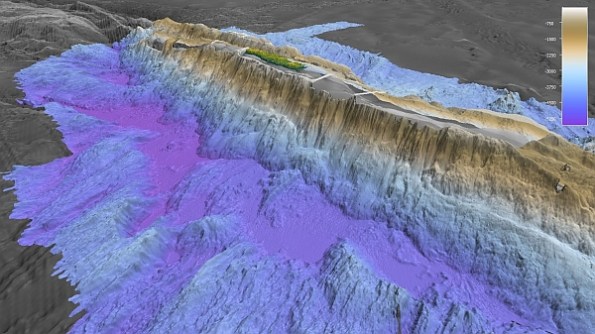
With only about 25 percent of the seafloor in Australia’s EEZ mapped to a modern standard, the wide-ranging voyages of RV Investigator have provided abundant opportunity to make some significant discoveries, including for our maritime heritage community. This is in part due to the vessel’s capacity to accommodate multiple projects on its voyages and a result of its full ocean depth mapping capabilities unlocking areas that could not previously be investigated.
In particular, the growing list of shipwreck discoveries made by RV Investigator have captured the interest and imagination of the community, while also providing closure for several enduring maritime mysteries.
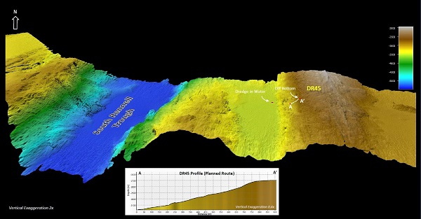
In 2019, a dedicated maritime heritage survey voyage was conducted in collaboration with seafloor mapping being undertaken in Bass Strait for the Australian Hydrographic Office. The voyage, which was led by a Chief Scientist from the Australian National Maritime Museum, was successful in locating several shipwreck targets. Most notable was the discovery of the wreck of the 100-metre SS Iron Crown. SS Iron Crown was an Australian freighter that was sunk in Bass Strait during World War II after being torpedoed by a Japanese submarine. The vessel had been lost for 77 years before it was located by RV Investigator.
More recently, RV Investigator undertook an investigation of an unidentified shipwreck off the west coast of Tasmania during a geoscience research voyage in 2023. The bathymetric data collected, along with imagery captured by RV Investigator’s underwater camera systems, confirmed the wreck as that of the MV Blythe Star. MV Blythe Star was a coastal freighter that disappeared without a trace after it departed Hobart, Tasmania on 12 October 1973. This triggered the largest maritime search ever conducted in Australia to that time. Unknown to searchers, all 10 crew members were able to escape the sinking vessel into an inflatable life raft but, tragically, three crew members would die before the survivors were rescued 12 days later.
These shipwrecks added to a growing list of maritime heritage discoveries made by RV Investigator which also includes uncovering the submerged cultural landscapes of Australia’s first peoples.
International cooperation
In 2022, CSIRO, Geoscience Australia and the United States’ National Oceanic and Atmospheric Administration (NOAA) signed a Memorandum of Understanding (MoU) to cooperate in ocean exploration and mapping. This will enable all organisations to benefit from the combined skills and experience that each brings to the table and open new frontiers in ocean research.
This partnership aligns with the United Nations Decade of Ocean Science for Sustainable Development (‘the Ocean Decade’) by emphasizing the importance of contributing to the Nippon Foundation-GEBCO Seabed 2030 Project, a formally endorsed Ocean Decade Action with the goal of producing a definitive map of the world ocean floor by 2030 and making the data freely available to all.
Advancing our capability
During 2024, RV Investigator will undergo its second scheduled 5-yearly dry docking. The activity will coincide with a middle of life refit project that will see upgrades to the vessel’s scientific capabilities, utility and amenity. These upgrades are funded by the Australian Government through the National Collaborative Research Infrastructure Strategy (NCRIS). With rapid advances and developments in technology since vessel commissioning, new MBES systems will be fitted to RV Investigator to maintain its state-of-the-art capabilities as it enters the next phase of its operational life.
The MBES upgrades involve three new Kongsberg systems with the following manufacturer-quoted specifications:
- Kongsberg EM 124 operating at 12 kHz and 1° x 1° beam footprint with mapping to 11,000 metres (full ocean) water depth
- Kongsberg EM 712 operating at frequencies in the 40-100 kHz range and 0.5° x 1° beam footprint with mapping to 3,500 metres water depth
- Kongsberg EM 2040 MKII with an operating frequency range of 200 to 400 kHz and 0.4° x 0.7° beam footprint capable of mapping to 600 metres water depth.
The new systems are compatible with the existing vessel infrastructure, reducing complexity for the upgrade integration and building on existing team knowledge and system familiarity. In addition to increasing operating depth for mid and shallow water surveys, the new systems will deliver a broad range of increased functionality including improved swath coverage and higher resolution data from a greater number of individual beams; enhanced small object detection in shallower waters for the EM 2040 MKII; and generally lower system noise resulting in superior data of increased resolution that will require less post-processing. In addition to increasing system and operator efficiency, the new MBES systems will also offer benefits from more modern and sophisticated electronics.
The introduction of these MBES systems will advance Australia’s capability for seafloor mapping and ensure RV Investigator continues to deliver high quality and high quantity bathymetric data for its next 10 years and 100 voyages.
Amy Nau is a Senior Acoustics Technician and Data Analyst with the CSIRO Geophysical Survey and Mapping (GSM) team with 10 years’ experience on RV Investigator. Concurrently, Amy is undertaking a PhD candidature at the University of Tasmania. Her research focuses on multibeam water column data and developing innovative solutions for processing and analysing acoustic data for application to new areas of marine research.
Philippe (Phil) Vandenbossche is a Senior Marine Geophysical and Hydrographic Surveyor with the CSIRO Geophysical Survey and Mapping (GSM) team. Phil has 26 years’ experience that spans shallow and deep-water survey and mapping applications. He holds a BSc (Hons), MSc and is a Certified Professional Hydrographic Surveyor Level 2 (CPHS2). Concurrently, Phil is undertaking a PhD candidature at University of Tasmania. His research focuses on the evolution of the seafloor of the Australian-Antarctic Southern Ocean.


