
Held on Sunday, 9th February, 2020, the SSSI National Bushfire Recovery Map-a-thon was a way for the national and international community to work together to map a total of 2,793,879 hectares affected by recent Australian bushfires with the focus being on burnt infrastructure. Join us for this Webinar to hear more about the initiative.
Speakers:
Dr Lesley Arnold (SSSI National Board Director) will give an overview of the Map-a-thon initiative and discuss overall logistics of planning; industry, government and NGO engagement; the challenges and overall execution of the event.
Nathan Eaton, Executive Director, NGIS Australia will give an overview of the technical set-up of this mammoth Map-a-thon and highlight some of the challenges and triumphs experienced.
This is a free event open to those who participated in the Map-a-thon or are involved in the surveying and spatial community.
Details about how to join the Webinar will be emailed to you prior to the event.
To read more about the SSSI National Bushfire Recovery Map-a-thon see the news item here

Eugene Lamnek created GeoIT Solutions in 2002, and has been developing ArcGIS customizations, add-ins and applications ever since. In this time Eugene has developed numerous bushfire applications for the CFS and the CFA as well as water and wastewater modelling software, asset management applications and interfaces, and open source applications for numerous clients including SA Water, Santos and DEW.
The Treatment Reporting System (TRS) currently in pilot phase, will allow organisations to store and manage their bushfire mitigation tasks, as well as measuring these tasks against the requirements of the Bushfire Management Area Plans (BMAPs). The system will allow users to store bushfire mitigation tasks, their spatial extent, values of work, time of work and completion status. Tasks are mapped and measured against required actions, defined by within the CFS BMAPs. The TRS will provide an effective mechanism for reporting the adequacy of on ground mitigation work (potentially at a State-wide level) by measuring mitigation work against well-defined mitigation targets. Users of the system will include local government, state government, private organisations and potentially even individual landholders.
Venue
Zoom Webinars
Cost
SSSI Members $30 | Non-Members $45 | SSSI YPs $20 | SSSI Student Members FREE
Contact
SSSI South Australia | rom.sa@sssi.org.au | 08 8212 0359

SSSI in conjunction with the Hunter Environmental Institute will present this webinar with three pre-eminent speakers:
Amy Steiger (Cardno)
Title: RPAS and thermal cameras for wildlife detection post-bushfire and coastal monitoring
Details: Amy has promoted the use of Remotely Piloted Aircraft Systems (RPAS) gaining experience with remote data capture to cover a range of coastal, environmental and land development applications.
RPAS thermal inspection capability was deployed this summer in wildlife detection post-bushfires.
Amy has also done volumetric surveys of beaches and flown isolated coastal cliff faces in NSW to capture high-resolution photography and derived photogrammetric models to identify geotechnical hazards and contribute to coastal monitoring.
Charity Mundava (WaterNSW)
Title: Remote Sensing in Water Management
Details: Charity will discuss the use of GIS and remote sensing to support water catchment management, feasibility and environmental studies for critical water infrastructure across the state and to support ongoing research into and management of river catchments. Charity will touch on the significance and spatial support for this in the recent NSW bushfires coordinating reservoir availability (in drought) and access for helicopter water drops and supporting bushfire fighting efforts.
Associate Professor In-Young Yeo (University of Newcastle)
Title: Remote sensing and GIS applications for water resources management
Details: Dr Yeo will explain how remote sensing can be used as a technique for assessing soil moisture using multi-source data fusion approaches, vegetation monitoring and water requirement with remote sensing and water balance approach.
She will explain the impacts of conservation management practices in agricultural catchments assessed using catchment model and remote sensing/GIS drawing on examples from Australian and American case studies
CPD Points
BOSSI CPD is 1 SP for this webinar.
Cost
As per details as follows
Contact
rom.nsw@sssi.org.au
Check out our upcoming Webinar which talks more about the Growing Data Foundation’s FireWater App and the SSSI FireWater Map-a-thon. Details are as follows:
Date: Wed, 7th October, 2020
Time: 12PM AEDT
RSVP: Further details click here
And don’t forget to register for the SSSI FireWater Map-a-thon here
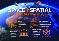
During 2020 an expert group drafted the SPACE+SPATIAL Industry Growth Roadmap 2030 – a national snapshot for Australian professionals to better understand the bold new future that’s rapidly approaching and what it means for them, their careers, their organisations and all of Australia.
The National Steering Committee is seeking feedback on the Roadmap from spatial professionals of all levels across the country. There are a number of ways to get involved, one of which is to participate in this SSSI and SIBA|GITA SPACE+SPATIAL Roadmap Online Session.
You will hear about the key plans, activities and issues and have the opportunity to have a meaningful discussion with colleagues about your thoughts on the Roadmap Consultation Paper and the topic in general.

The FIG Congress — the largest and most prestigious conference of surveying and geospatial professionals — will this year be held in Poland.
The organisers are expecting an attendance of 1,000 to 1,500 surveying and geospatial experts from all over the world.
This year the local host is the Association of Polish Surveyors, and the conference theme is ‘Volunteering for the future – Geospatial excellence for a better living’. Geospatial excellence and all related professions and topics are now seen in a much broader context and as public goods and beneficial for the well-being and betterment of the entire society.
The sub themes are:
- Surveyor 4.0
- The surveying profession in and after COVID times
- Open access to data
- Surveying competence for other disciplines
The FIG Congress 2022 will give passionate professionals the opportunity to:
- Learn globally, with participation from around 80 to 90 countries
- Learn across silos, from other countries, industries and professional roles – with sessions and representation from a broad range of surveyors and geospatial experts
- Have influence on careers, organisations and communities
Each year, the Locate conference attracts hundreds of national and international delegates from within and outside the spatial and surveying industry.
As Australia’s premier spatial and surveying conference, Locate provides guests with a unique opportunity to learn about the latest trends and applications in geospatial technologies.
Are you passionate about our industry and want to get involved? Maybe you have an idea for a local tour, or a project site visit or even have another event that can run in conjunction with Locate. This is your opportunity to help shape the 2023 event — no idea is too big or too small. Reach out to the organisers via info@locateconference.com or +61 2 4319 8519.
The overall theme for the FIG Working Week 2023 will be ‘Protecting our world, conquering new frontiers,’ which refers to the importance of looking ahead and discovering what will be needed in the future for our profession and at the same time make sure to preserve what works well today.
The FIG Working Week 2023 will give passionate professionals the opportunity to:
- Learn globally, with participation from around 80 to 90 countries.
- Learn across silos, from other countries, industries and professional roles, with sessions and representation from the broad range of surveyors and geospatial experts.
- Make impacts on careers, organisations and communities.

INTERGEO returns for 2023 with the motto, ‘Inspiration for a smarter world,’ with the event this year also incorporating the German Cartography Congress.
The conference and exhibition will cover the topics of geoinformation, geodesy, land management, Earth observation, urban planning, disaster prevention, environmental protection and energy efficiency, while tackling challenges such as the climate crisis, urbanisation and securing resources.
This year, there will be a special emphasis on drone technologies and BIM.
The International Federation of Surveyors (FIG) Working Week 2024 will be held in Accra, Ghana, from 19 to 24 May. The event is being held in cooperation with the two national associations: the Licensed Surveyors Association of Ghana (LiSAG) and the Ghana Institution of Surveyors (GhIS).
The event will comprise the following:
- Conference: 20-22 May
- FIG General Assembly: 19 and 23 May
- Pre- and post-events: 18-19 and 23 May
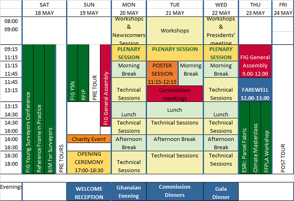
The FIG Working Week will be a week-long celebration of innovation and collaboration that unites the global community of surveying and spatial professionals, providing an opportunity to bridge the gap between science and the policymakers and stakeholders who drive real-world change.
The event will provide attendees the opportunity to:
- Immerse themselves at the forefront of geospatial technology and sustainable resource management.
- Elevate their expertise through hands-on workshops, interactive sessions, and thought-provoking discussions.
- Connect with like-minded professionals, experts and decision-makers from around the world.
The FIG Working Week 2024 is expected to attract more than 1500 attendees from around 80 countries, to participate in 70-plus presentation sessions and networking opportunities, and to experience a comprehensive trade exhibition.


