AVALON 2019 – THE ESSENTIAL AVIATION, AEROSPACE AND DEFENCE SHOWCASE FOR AUSTRALIA AND THE ASIA PACIFIC REGION
The Asia Pacific region is undergoing major growth in defence and aviation, with budgets in many countries continuing to rise and an ever increasing level of sophistication in technologies, equipment, systems and operational methods.
One of the leading gateways to these important markets is AVALON 2019 – the Australian International Airshow and Aerospace & Defence Exposition staged at Avalon Airport, Geelong, Victoria.
AVALON 2019 will again present a unique opportunity to showcase products, technologies and services to an informed target audience and to demonstrate a marketing presence in this vibrant and vital region. High levels of economic growth and technological development have resulted in growing demand for aviation and aerospace services, products and technology, right across the spectrum from General Aviation to airlines, air forces and space.
AVALON 2019 will be a valuable opportunity for decision-makers to be informed and for exhibitors to connect with their customers.
The Australian International Airshow and Aerospace & Defence Exposition is the essential aviation, aerospace and defence event for the Asia Pacific.

Are you a young surveyor and always wondered what the digital frontier of the profession looked like? Are you mid career but developed foundation skills but have not yet ventured into the digital data part of the discipline? Are you a seasoned professional who loves to see what amazing things you can do with the tools and technologies of the 21st century?
If you answered yes to any of those questions then this is a webinar you won’t want to miss!
Michael Finlay is a Geospatial Engineer who specialises in 3D laser scanning and point cloud technologies. He is an early career professional who has been working at Jacobs for 8 years and is passionate about all things 3D laser scanning, especially mobile laser scanning (MLS). Michael is a trail blazer in developing the digital data team and discipline at Jacobs as not only a real value add, efficiency but product and service enricher for the surveying team. He gets involved with the planning, scanning, processing, adjusting, classifying, extracting, automation, analysis, visualisation and supports the interfaces of surveying and digital engineering and GIS environments for stakeholders from a broad variety of disciplines.
Check out Michael’s profile to see some of the amazing projects he has been involved in and how he champions this modern digital space for surveying and geospatial engineers.
Registration
By registering below, you receive access to the watch the webinar live OR if you can’t watch it live, you receive the link to the recording 24 hours after the event date. You can then watch the recording at your leisure.
CPD
This event is worth one SSSI CPD Point. BOSSI points to be confirmed.
Note, only the individual registered for the event is entitled to receive the associated CPD points.
Contact
Katie Le Miere, National Events Manager
katie.lemiere@sssi.org.au

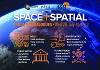
During 2020 an expert group drafted the SPACE+SPATIAL Industry Growth Roadmap 2030 – a national snapshot for Australian professionals to better understand the bold new future that’s rapidly approaching and what it means for them, their careers, their organisations and all of Australia.
The National Steering Committee is seeking feedback on the Roadmap from spatial professionals of all levels across the country. There are a number of ways to get involved, one of which is to participate in this SSSI and SIBA|GITA SPACE+SPATIAL Roadmap Online Session.
You will hear about the key plans, activities and issues and have the opportunity to have a meaningful discussion with colleagues about your thoughts on the Roadmap Consultation Paper and the topic in general.

The Survey and Spatial New Zealand 2021 Annual Conference will draw on the ability of individuals and teams to adapt to change, adversity and setbacks in the current environment.
The conference program will include presentations on rebuilding and improving the economy, with a focus on resilient mindsets to support our members while they navigate the challenges and changes ahead. By sharing concepts, ideas and knowledge, industry members have opportunities to help build back the survey and spatial sector.

As Australasia’s premier annual industry event, the Disaster & Emergency Management Conference attracts a passionate crowd of leaders and change-makers from government, private, and volunteer agencies working in disaster and emergency management.
Over two days, you will connect with emergency management professionals and subject matter experts offering insight, reflection, understanding and motivation across a wide range of topics and emergency management incidents.
Enjoy an impressive line-up of keynote speakers, presenters, and panel discussions, and leave with practical tools and techniques to ensure your team is best supported to better plan, prepare, and respond to emergencies, disasters, and rescue operations.
- Connect with emergency management personnel from state and local government, NGOs, and other recovery agencies.
- Explore and engage with exhibitor displays featuring the latest equipment, technologies, and agency services.
- Discover what is happening across multi-sectors via a program of renowned keynote speakers, sector representatives and lived-experience presenters.
- Gain practical tips, techniques, and strategies to incorporate into your organisation to improve the way you approach disaster and emergency planning, response & prevention.

Survey and Spatial NZ’s 2022 conference will be held from 1 to 3 August at the Novotel Lakeside, Rotorua. The conference is the biggest continuing professional development event of the year for NZ surveying and spatial professionals. It invites sharing of knowledge amongst peers, bringing together networking opportunities for all delegates and is an essential event for professional development and connectivity within the sector.
The choice of Rotorua as the location is apt, given the conference theme of ‘Turning up the Heat’. The organisers aim to stimulate discussion regarding challenges in regional areas, which include climate change and developments outside of Auckland.

The 2023 Disaster & Emergency Management Conference (DEMC) will be held from 11 to 12 July 2023 at the RACV Royal Pines Resort on the Gold Coast.
The DEMC brings together a cross sector mix of Australian & New Zealand defence, emergency services, business and community services at a leadership level to zone in on the current challenges and trends of the sector, in order to promote inter-agency collaboration and unity.
Over two full days, the DEMC will explore topics such as:
- Resilient Communities – Engagement, participation, partnering and capacity building.
- Applying the learnings from the past to create meaningful change for the future.
- Inter-agency and volunteer cooperation and knowledge sharing.
- Thriving leadership, employees wellbeing and engagement.
- Risks of Disasters – Mitigation, reduction, management.
- First Nations cultural perspectives in disaster and emergency management.
- Beyond 2030: A climate challenged world.
Delegates will hear the leaders in the field discuss these topics plus learn the latest innovations, research findings, current challenges and future predictions so that prevention, preparedness, response and recovery strategies are as strong as they need to be.

The Local Government Spatial Reference Group (LGSRG) will be holding a webinar on Monday, 4 September, to introduce a series of hands-on workshops it will be holding across Victoria during September 2023.
The webinar will cover the topic of Best Practice Geospatial Intelligence for Climate Impact, and will address important topics on climate impact, community safety and how geospatial intelligence can contribute to better outcomes for local governments.
The LGSRG was formed in 2003 to address the need for a sector wide group representing the strategic interests of the Victorian Local Government sector with respect to spatial information. The LGSRG has been active throughout the COVID pandemic to keep the local government geospatial community connected and engaged via the annual Spatial Capability Workshop series which have grown year on year, and is now diversifying with a quarterly Spatial Hour webinar to share stories of success within the local government geospatial sector.
Image credit: ©stock.adobe.com/au/yutthana

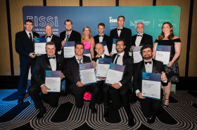
Each year representatives from the Association of Consulting Surveyors NSW and the Institution of Surveyors NSW come together to organise the NSW Excellence in Surveying and Spatial Information (EISSI) Awards.
The awards recognise the achievements of organisations and individuals from across the state who are engaged in the surveying and spatial information profession; celebrate excellence before an audience of industry peers; encourage activities that create a stronger, larger and more relevant industry; and embrace the achievements of the industry and its related industries and professions.
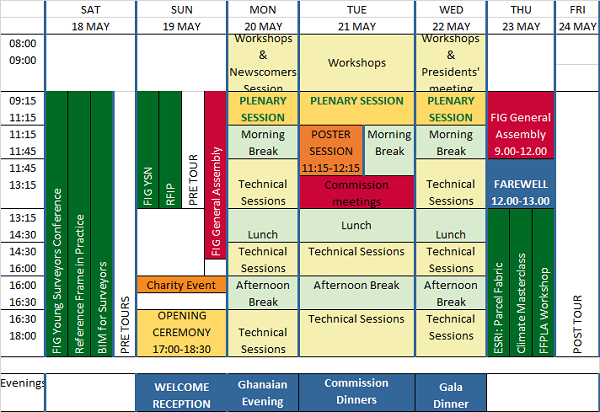
The International Federation of Surveyors (FIG) Working Week 2024 will be held in Accra, Ghana, from 19 to 24 May. The event is being held in cooperation with the two national associations: the Licensed Surveyors Association of Ghana (LiSAG) and the Ghana Institution of Surveyors (GhIS).
The event will comprise the following:
- Conference: 20-22 May
- FIG General Assembly: 19 and 23 May
- Pre- and post-events: 18-19 and 23 May

The FIG Working Week will be a week-long celebration of innovation and collaboration that unites the global community of surveying and spatial professionals, providing an opportunity to bridge the gap between science and the policymakers and stakeholders who drive real-world change.
The event will provide attendees the opportunity to:
- Immerse themselves at the forefront of geospatial technology and sustainable resource management.
- Elevate their expertise through hands-on workshops, interactive sessions, and thought-provoking discussions.
- Connect with like-minded professionals, experts and decision-makers from around the world.
The FIG Working Week 2024 is expected to attract more than 1500 attendees from around 80 countries, to participate in 70-plus presentation sessions and networking opportunities, and to experience a comprehensive trade exhibition.


