


Low Earth orbit satellite observations are revolutionising industries and accelerating society’s journey towards sustainability.
By Dr Newton Campbell, Director of Space Programs, AROSE
Some say the next and most profound industrial revolution in human history is underway in low Earth orbit (LEO), 400 kilometres above our heads.
According to Tom Vine, the CEO of US-based space infrastructure company Sierra Space, we are at a turning point in human history, pivoting from 60 years of space exploration to a new era of unprecedented economic activity, manufacturing and growth focused in space.
While future space exploration is likely to have profound impacts here on Earth, LEO satellite observation is generating benefits today.
LEO observation is improving technology, productivity and sustainability across a wide range of industries. Benefits include better land and water resource management, mitigating the impacts of climate change, and enabling greater, more effective use of remote operations.
Creative uses for data gathered from space abound. For instance, companies are increasingly turning to remote sensing data to inform business decisions, such as tracking the number of cars parked at shopping centres, detecting gas pipeline leaks, optimising airline flight paths and fuel consumption, or assessing soil type and moisture content to maximise crop yields.
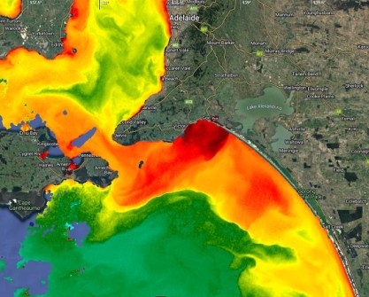
Satellite imagery already helps us observe and manage our environment and the impacts of climate change, from flood and fire identification to better water and mineral resource management.
Australia’s fire agencies are using AI to analyse satellite-generated data and images to help plan for bushfire seasons. By analysing historical bushfire data, vegetation growth and moisture, they can identify where fires are most at risk of breaking out. This helps the agencies decide when and where to backburn and where to deploy resources. They can also combine this data with analysis of social media, using AI to track key words and images, such as pictures of smoke.
Hyperspectral imaging
Satellites deployed with hyperspectral imaging greatly enhance characterisation of the Earth. They can improve the search for deposits of critical minerals required for lower CO2 technologies, including for battery storage and solar panels.
Hyperspectral imaging can also help us characterise longer-term emergencies. For example, Coral Vita, a Bahamas-based organisation specialising in coral reef restoration, is pioneering the use of visual spectrum satellite data and LiDAR to peer down across whole coral systems. This is helping to identify degraded areas for out-planting with site-specific and climate change-resilient farmed corals.
However, recent research by Coral Vita and NASA has shown there are inherent limitations in standard visual and LiDAR sensors that prevent us fully capturing the complexity and diversity of coral reefs.
For instance, these standard mechanisms cannot measure specific key indicators of coral health, such as tissue thickness, skeletal density or symbiont density. These indicators are influenced by factors such as water temperature, light intensity, nutrient availability and disease exposure. They can also vary significantly within and between coral colonies, making them hard to detect from space.
Some costly solutions to address these limitations include coupling standard remote sensing data with other methods of coral assessment, such as underwater surveys, genetic analysis and physiological measurements.
In the future, more advanced hyperspectral imaging could enable us to narrow down the health properties that currently elude us.
By analysing spectral data, researchers could identify different types of coral species, as well as their health status and environmental conditions. Hyperspectral imaging could help to detect stress, bleaching or disease in coral reefs by revealing changes in their pigmentation, morphology, and metabolism. For example, bleached corals have lower reflectance in the visible spectrum and higher reflectance in the near-infrared spectrum than healthy corals.
Hyperspectral imaging could also help to monitor the recovery of coral reefs after a disturbance event, such as a storm or a heat wave, by tracking the changes in their spectral characteristics over time. This, in turn, would allow us to prioritise more areas for restoration with a precision that was previously impossible.
Earth applications
The application of space-accelerated technologies is also creating a wide range of new and more diverse employment opportunities, in space and across all Earth-based industries. The future looks brighter for young people contemplating their career choices.
One of the Australian Remote Operations in Space and on Earth (AROSE) consortium’s most important goals is to uncover and widen the application of this space capability across industries to improve our approach to sustainability and decarbonisation.
AROSE members are at the forefront of these innovations. Many are using LEO satellite observation and communications to improve productivity and sustainability, while creating a more diverse and skilled workforce. Some examples include:
- MDA is helping Global Fishing Watch combat large-scale illegal fishing using the company’s 14-year RADARSAT-2 satellite radar archive, which includes more than 970,000 images. RADARSAT-2 can image more than 250,000 km2 of ocean in less than a minute, regardless of weather conditions and time of day.
- Gilmour Space, Curtin University and UNSW are developing and deploying satellite technologies that will increase Australia’s Earth observation capability.
- Curtin University under SmartSaT CRC funding has used Earth observation optical data to help the Western Australia rock oyster industry prototype near-real time monitoring of farming sites.
- EngineRoom’s high-performance computing helps companies supercharge the masses of satellite-generated data to increase crop yields, render blockbuster visual effects, develop and simulate medical breakthroughs, calculate re-entry profiles for spacecraft, and give machine vision to robots and autonomous vehicles.
- The Oceans Institute at the University of Western Australia (UWA) is using AI to analyse satellite data and images to identify plastic dumps in rivers before they enter the ocean, and climate change resilient coral formations in the Great Barrier Reef.
- UWA’s International Space Centre has a dedicated facility developing world-leading hyperspectral infrared sensors, imaging devices, and electronic systems for space-based Earth observation.
As we stand at the dawn of this new era in space exploration, we must be mindful of the environmental challenges we face as a planet. With continued research and development, we can harness the power of LEO satellite observation to help create a more hopeful and sustainable future.


