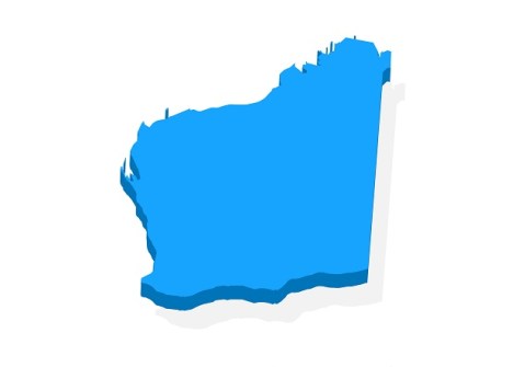
WA’s Advanced Spatial Digital Twin will see an entire third of the continent replicated in spatially accurate 4D.
By Jonathan Nally
The Government of Western Australia made headlines a couple of months ago when it announced the establishment of the $140 million Spatial WA program and its aim to deliver for Western Australia an Advanced Spatial Digital Twin (ASDT). The ASDT will be a spatially accurate 4D virtual representation of the built and natural environment.
Think about that. That’s the entire western third of Australia turned into a spatial digital twin. It’s a mammoth job that is being led by the Western Australian Land Information Authority, which is more commonly known as Landgate.
Not a lot of information about Spatial WA has been released publicly yet, so we reached out to Landgate with some questions and a request for more detail about the project. The following are the responses we received from a Landgate spokesperson.
Are Spatial WA and the ASDT different names for the same thing?
Spatial WA is the program of work that will deliver Western Australia an Advanced Spatial Digital Twin. The ASDT will provide Government a new digital capability that will deliver a digital, spatially accurate representation of WA’s built and natural environments.
Led by Landgate, Spatial WA has been developed in consultation with more than 30 government agencies, highlighting the need to better leverage spatial and non-spatial digital data to support government priorities.
The ASDT will maximise the value of the state’s data by creating a spatially accurate 4D virtual representation of the built and natural environment, supporting key government priorities around infrastructure delivery, planning reforms and emergency preparedness.
The ASDT will be made up of two technology platforms.
The first is the Next Generation Spatial Cadastre, which will provide the technology to uplift the state’s current 2D spatial cadastre to maintain property rights, restrictions and responsibilities in 3D/4D across government.
The second is the Spatial Digital Twin, which will provide a digital, spatially accurate representation of the built and natural environment with the capability to share, discover, visualise and analyse data about a place at a specific time.
Importantly, Spatial WA will be enabled through a separate stream of work focussed on data modernisation, to ensure that the required data is captured, maintained and accessible through the ASDT, meeting the needs of end users.
How long has this project been in the works?
Landgate commenced investigations in 2019 into the development of this new digital capability.
From these investigations, the need emerged for a whole of government platform with advanced capabilities to enable government to better collaborate, analyse data, streamline workflows and run scenarios supporting planning, projects and investment decisions.
$12.4 million was secured in the 2023-24 state budget. Does the newly announced $140 million include this amount?
Yes. In the 2023–24 State budget, Spatial WA was endorsed and we received the first year of funding to begin the Spatial WA journey. A condition of the funding was to develop a comprehensive Project Definition Plan (PDP), validating our approach to delivering Spatial WA, providing confidence to government on this significant investment.
This is a significant investment into advancing digital capabilities through a spatial digital twin platform in Australia, and since the development of the PDP we have secured the remaining funding for the program and have started working with our partner agencies in the delivery of the ASDT.
Are you able to give a timeline for the project?
Spatial WA will be delivered across two Horizons.
Horizon One will focus on the delivery of four priority use cases for government that will demonstrate the benefits and value of an ASDT to Western Australia. Within this Horizon, significant investment will be directed toward having skilled people engaged in the program to lead the delivery of the use cases, and, importantly, there are several data roles that will work with our partner agencies to uplift data from a 2D to 3D/4D. The Data Management Framework we are developing will be a cornerstone for the program as it sets the foundation to ensure data is appropriately managed across its lifecycle and is fit for purpose for the priority use cases.
The technical capability for Spatial WA will be implemented in Horizon One, the initial five years of the program, and our criteria for success will be based on demonstrating the desired outcomes of the four priority use cases and realising the benefits for government.
Those priority use cases are:
- Infrastructure projects and asset management.
- Digital approval workflows for development application referrals.
- Coordinated management of administrative land boundaries.
- Exposure modelling for emergency management.
Horizon Two will see Spatial WA scale and expand its use across government and provide opportunities for use by the public and private sector.
Spatial WA is to be ‘whole of government’. Does this include local government?
Several of our priority use cases will need to work with local governments to ensure they have the tools and data needed to support their operations. Importantly, the state can streamline access to data, especially where the state and local governments need to collaborate (for example, digital approval workflows deal with land development involving many stakeholders).
Once these priority use cases have been delivered, Spatial WA will scale and expand to enable the public and private sector to use the ASDT, becoming a single location to discover, access and use government data.
Will the work be done in-house, or will solution providers be engaged too?
Spatial WA is a government-led program, meaning the development and management of the program is directed by a dedicated team working in collaboration with Landgate and more than 30 government agencies.
We currently have an active tender in the market to develop and implement the two technology platforms required — the Next Generation Spatial Cadastre and the Spatial Digital Twin.
Once the tender is awarded, the successful applicant will work hand-in-glove with the broader Spatial WA team as we venture towards delivering the ASDT.
What are some the known challenges you’re going to face?
Navigating the challenges ahead requires a holistic approach that addresses both technological and cultural shifts. We have been steadfast on not wanting to deliver a ‘proof of concept’ for WA. We know the technology exists; there are countless examples around the world with over 500 governments using these types of technologies.
Central to our approach is changing behaviours to recognise the value of digital ‘spatial’ data and ensuring we are not pigeonholed as a ‘GIS’ platform. The scale of change required and a focus on having a framework to capture, manage and use digital data requires people to be engaged at all levels.

Does the data for the ASDT already exist and just it’s a matter of bringing it all together?
Much of the data exists across government and the Spatial WA program is replacing two legacy systems. We need to work across our partner agencies to access the wealth of ‘other data’ that is captured through separate procurement processes and is isolated and locked away but required for our priority use cases. This means the program will actively work with data custodians to improve how their data is managed and published into the ASDT (with appropriate security controls where needed) to support these priorities.
Some of the data types we need relates to asset and infrastructure, financial, planning, demographic and community services, data that is captured and managed for different purposes. This will require building new relationships with data custodians outside of the spatial area. That said, most of this information relates to a location and so demonstrating the value of ‘where’ becomes an important communication factor for the program.
The known existing data currently resides in legacy systems built on old technology such as the Spatial Cadastre Database (SCDB) which maintains a critical dataset required for land titling. As the SCDB contains land parcel boundaries and tenure information for all Crown and freehold lands in Western Australia, it is important we understand what moving to 4D means for this data so when it is managed within the Next Generation Spatial Cadastre (NGSC) platform it becomes a central point for all of government.
The second legacy system is the Shared Location Information Platform — known as SLIP — which is the WA Government’s current platform for sharing location-based information that can be provided to government, business, researchers and the public.
Once Spatial WA delivers the Advanced Spatial Digital Twin, any remaining data that we have not used for the priority use cases will be migrated from SLIP and the platform will be decommissioned. This is expected to occur in Horizon Two.
Are some digital twin elements already in place in WA?
The current environment in WA presents a landscape characterised by disparate systems and pockets of existing initiatives. While the concept of digital twins is not new, these initiatives are in isolated systems across WA. Our approach is not to replace these but rather put in place new digital capabilities that connects these systems while providing new capability for agencies that currently don’t have spatial capabilities in place.
An advantage we have in WA is WALIS, a community of practitioners who have worked tirelessly over many years to improve the awareness and value of spatial data. Leveraging this existing community, we are ensuring Spatial WA delivers value for the target users of the platform, while also ensuring long term sustainability by the practitioners who maintain the data required for the target users.
Will the ASDT have different capabilities for urban areas versus remote areas?
At a high level, the technology underpinning Spatial WA will need to provide the ability to combine spatial and non-spatial data to generate analytical insights, run predictive modelling, and streamline digital workflows, irrespective of the subject or location. We need to ensure we deliver a platform that enables government to work with industry and the community to deliver the priorities of the day.
Can you give some examples of how the ASDT will benefit the community?
Spatial WA will provide significant benefits for the community, both in its initial stages and upon completion. In its early stages, the ASDT will focus on designated priority use cases, demonstrating capabilities through practical application.
In the initial years, we want a pragmatic approach that prioritises outcomes for our priority use cases so that we can measure and demonstrate benefits. Once we have demonstrated and measured the benefits relating to each priority use case, we will then focus on the wider community and industry benefits.
Spatial WA represents an initiative to support decision-making processes and service delivery across Western Australia. By harnessing quality location data pertaining to both the built and natural environment, Spatial WA will empower government, industry and the public with the tools and insights needed to make informed decisions.
Ultimately, providing accurate and accessible data will empower stakeholders to make targeted project investments, resulting in more efficient infrastructure delivery.
Are you looking to other spatial digital twins for ideas?
We have built strong connections with our jurisdictional counterparts, where we regularly share information on our individual digital twin journeys. We are lucky that NSW and Victoria are more progressed in their development journeys, and we have learnt from their approach to frame our Spatial WA program.
For example, we had a recent discussion on how best to collaborate on machine learning and artificial intelligence models that can be used to drive insights that are common across Australia. These discussions help us to think differently on the role of government and how we can move our activities further along the value chain. This ultimately will allow government to spend more time on high value activities and leave the manual, repetitive tasks to the technology.
We also know that these types of technologies have been used by more than 500 different government agencies and organisations around the world, and there has been great global collaboration to share information around the best practice for digital twins.
We recognise the value of learning from existing initiatives and leveraging best practices to inform the direction we are headed, including participating in the recent national Digital Twin Workshop hosted by Geoscience Australia in Canberra. Collaborative sessions with other digital twin teams from across the country enables us to exchange insights and explore opportunities to advance this technology.