The United Kingdom’s re-entry into the EU’s Copernicus program has been credited with providing the necessary funding for final approval to be granted for the development of all six Copernicus Sentinel Expansion Missions.
The Expansion Missions will expand upon the capabilities of the current generation of Sentinel satellites, such as the Sentinel 1 synthetic aperture radar spacecraft and the Sentinel 2 optical imaging craft.
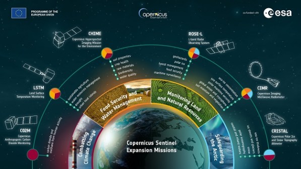
The individual missions will be:
- CO2M, a constellation of three satellites that will track greenhouse gas emissions.
- CIMR, comprising two satellites equipped with a microwave radiometer to provide detailed insights into sea ice and the polar environment.
- CHIME, a duo of satellites carrying a visible-to-shortwave infrared spectrometer to gather hyperspectral observations from Earth’s surface.
- CRISTAL, a successor to the CryoSat mission, will be two satellites carrying a dual-frequency radar altimeter and microwave radiometer to monitor ice thickness and change.
- LSTM, two satellites hosting a high spatial-temporal resolution thermal infrared sensor to map land-surface temperature variations.
- ROSE-L, a satellite duo carrying a synthetic aperture radar for high-resolution, all-weather imaging with a spatial resolution of 5 to 10 metres. The antenna will be the largest deployable planar antenna ever built, measuring 40 square metres.
“The decision by the UK Government to participate to the EU Copernicus Programme has been essential to secure the completion of the Copernicus Sentinel Expansion Missions,” said Simonetta Cheli, ESA’s Director of Earth Observation Programmes.
“These missions are critical for addressing EU policy and gaps in Copernicus user needs, and to expand the current capabilities of the Copernicus Space Component.”