


The watsonx.ai geospatial foundation model, based on NASA satellite data, is now openly available on Hugging Face.
Search results for "nasa"
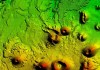
Geospatial tech for lunar landing simulations
The technology will provide elevation data and radar imagery of a test location in the Arizona desert.
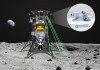
Australian company to develop lunar navigation
Advanced Navigation has been awarded $5.2m in funding to advance autonomous navigation on the Moon.

Groundwater use has nudged the Earth’s spin
Mass redistribution from groundwater use has made the Earth’s rotation wander nearly a metre in two decades.

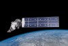
RFT issued for second SouthPAN satellite payload
SouthPAN GEO Payload – 02 will provide redundancy and resilience, leading to safety-of-life certification in 2028.
SmartSat CRC Conference 2023
When:
12 October, 2023 – 13 October, 2023 all-day
Where:
National Wine Centre, Adelaide
SmartSat partners, participants, students and staff are invited to come together to share their research outcomes and network with industry colleagues at the SmartSat CRC Conference 2023. The SmartSat CRC is a consortium of universities[…]

Next-gen EO hubs on the agenda
An RFI has been issued to explore options for the next generation of National Earth Observation Data Hubs.

Developing better digital terrain elevation models
With a 50-year legacy, Digital Terrain Elevation Data inches towards its next goal: 10-metre post spacing.

Here’s what’s in our latest issue!
The Feb/Mar 2023 issue of Position magazine is out now, packed full of all the latest geospatial news.

LINZ assists clients in wake of Cyclone Gabrielle
Essential services are being maintained in the wake of the Southern Hemisphere’s costliest cyclone.