

More than 30 people have graduated from a course on geospatial analysis of seagrass and mangrove ecosystems.
Search results for "GIS"

PreGISP program for emerging GIS professionals
The GISCI PreGISP program aims to help emerging GIS professionals gain early industry recognition.

Google’s Photorealistic 3D Tiles for ArcGIS suite
Esri has announced that Google’s Photorealistic 3D Tiles will be integrated into its ArcGIS suite.

QGIS WCPS plugin for multidimensional datacubes
The new QGIS WCPS Plugin enables seamless querying and visualisation of multidimensional datacubes.
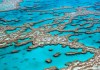
GIS, AI to the rescue for the Great Barrier Reef
Australian researchers are designing a global real-time monitoring system to help save the world’s coral reefs.

FIG/Locate early bird registration extended
The early bird registration deadline for the combined conferences has been extended to 17 February.

NASA Earth science data now in ArcGIS Living Atlas
The Living Atlas of the World now features NASA data formatted specifically for GIS users.

Certified GIS Professional exam dates announced
The GIS Certification Institute has set the testing window for its Geospatial Core Technical Knowledge Exam.

Early bird registration: Locate25/FIG WW 2025
Registration is now open for the joint Locate25 and FIG Working Week 2025 event to be held in Brisbane in April.
GISTAM 2025
When:
1 April, 2025 @ 9:00 am – 3 April, 2025 @ 5:00 pm
Where:
Porto, Portugal
GISTAM 2025, the 11th International Conference on Geographical Information Systems Theory, Applications and Management will be a meeting point of researchers and practitioners that address new challenges in geospatial data sensing, observation, representation, processing, visualisation, sharing[…]
