

Australian researchers are designing a global real-time monitoring system using GIS and AI technologies to help save the world’s coral reefs from further decline, primarily due to bleaching caused by global warming.
Coral reefs worldwide are dying at an alarming rate, with 75% of reefs experiencing bleaching-level heat stress in the past two years.
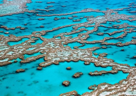
The World Heritage-listed Great Barrier Reef has been decimated by severe bleaching events since 2016, exacerbated by ongoing crown-of-thorns starfish outbreaks and coastal development.
A collaborative project led by the University of South Australia (UniSA), with input from Queensland and Victorian researchers, is integrating remote sensing technologies with machine learning, AI and GIS to monitor and hopefully stall the damage to the world’s most fragile marine ecosystems.
A multimodal platform will distil all research data relating to coral reefs, including underwater videos and photographs, satellite images, text files and time-sensor readings, onto a central dashboard for real-time global monitoring.
UniSA data analyst and lead researcher Dr Abdullahi Chowdhury says that a single centralised model will integrate all factors affecting coral reefs and provide environmental scientists with real-time predictions.
“At the moment we have separate models that analyse substantial data on reef health — including bleaching levels, disease incidence, juvenile coral density and reef fish abundance — but these data sets are not integrated, and they exist in silos,” Dr Chowdhury says.
“Consequently, it is challenging to see the ‘big picture’ of reef health or to conduct large scale, real-time analyses.”
The researchers say an integrated system will track bleaching severity and trends over time; monitor crown-of-thorns starfish populations and predation risks; detect disease outbreaks and juvenile coral levels; and assess reef fish abundance, diversity, length, and biomass.
“By centralising all this data in real time, we can generate predictive models that will help conservation efforts, enabling earlier intervention,” according to Central Queensland University PhD candidate Musfera Jahan.
The technology will bring together datasets from organisations such as the National Oceanic and Atmospheric Administration, the Monterey Bay Aquarium Research Institute, the Hawaii Undersea Research Laboratory and the CSIRO.
“The future of coral reef conservation lies at the intersection of technology and collaboration. This research provides a roadmap for harnessing these technologies to ensure the survival of coral reefs for generations to come,” the researchers say in a recent paper published in the journal Electronics.


