

PARTNER FEATURE
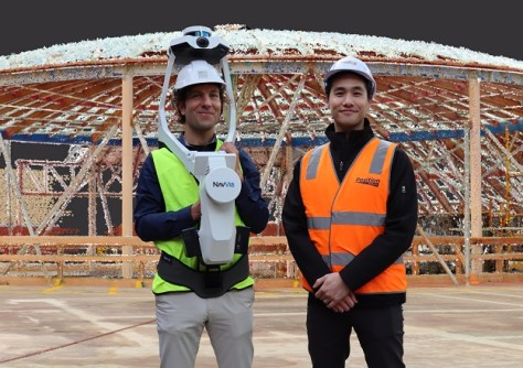
Tasmanian engineering firm Gandy and Roberts is winning over clients using the NavVis VLX mobile mapping system.
Tasmanian engineering firm Gandy and Roberts recently deployed mobile mapping technology to improve its service offering for architects and builders through accurate, accessible point clouds at all stages of the construction lifecycle.
As advocates for technology to increase efficiency and reduce rework, the team at Gandy and Roberts encourages clients to try out innovation and new methods.
“The construction industry is notoriously slow at embracing technology, but our clients appreciate that we think outside the box a little bit and suggest giving new methods a try, both for the architects at the design phase and later the construction team,” said Klaus Stroehl, a company director.
Klaus said he has kept a close eye on scanning technology for the last few years, and the company has hired terrestrial 3D laser scanners for some projects. “We were waiting for the right solution and a few projects to come to life that we could use it on before we took the next step,” he said.
“I first experienced point cloud scanning technology in 2010 at a project for Frankfurt Airport in Germany. It was fascinating technology, but inaccessible at that time because it was very difficult and time-consuming to capture and process the data. Not to mention how expensive it was!”
Despite the huge advancements in processing capabilities and data capture since, Klaus explained that on many projects it was still a costly and time-consuming exercise to produce and manage a 3D point cloud.
Making point clouds accessible
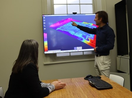
“We hired a terrestrial scanner for a university redevelopment project in Launceston two years ago,” Klaus said. “It took me five full, 12-hour days to capture the data with around 900 scan stations, then a further week or two to process it all and stitch the data together. We then ended up with this huge data set that we couldn’t share easily with all stakeholders because it was just so big and difficult to use for untrained users. It was great data and of huge value to the project, but the workflow was still cumbersome and required specialised skills to manage it.”
When he heard about the wearable NavVis VLX mobile mapping system, Klaus thought it could be just the solution they were looking for. “By coincidence, my brother-in-law in Frankfurt was working with point clouds again and had used the VLX. When I heard how easy it was to use, I couldn’t wait to see it when it came to Australia.”
Intelligent positioning solutions provider, Position Partners, is the Australian distributor for NavVis.
“Position Partners has been great onboarding us with the VLX. The instrument is very user-friendly, and we already understood the general concepts of how registration works, so it was easy to learn,” Klaus said. “A few times we had some technical issues or things that didn’t quite line up, and we weren’t sure if it was a user error or a system one. The Position Partners team has been very helpful and prompt with their support.”
With the ability to scan large areas as you walk, the NavVis VLX cuts down the time it takes to capture the data drastically. “Even on a large project, the scanning time is reduced to a day, maximum two,” said Klaus.

Processing the data is also seamless. “Because the workflow is so much more efficient and less time consuming, we can cost it at a price point where clients are willing to give it a try,” he added. “Previously, it was quite an investment, so understandably customers were more hesitant and would often stick to less-reliable paper plans and old methods, exposing clients to risk.”
Impossible projects made possible
Since purchasing their VLX a couple of months ago, Gandy and Roberts has completed some projects that would have otherwise been impossible. “We’ve done a large scan of parts of the local hospital, including the emergency department. I don’t know how we could have done that with a terrestrial scanner. You couldn’t have put a tripod up in prominent locations in a busy emergency ward without significant interruption and there is no down time in ED.”
It’s on jobs like the hospital project that using 3D documentation can really prove its worth, according to Klaus. “In these older buildings, you’ve got plans and documentation that are perhaps 60 years old. It’s very hard to read and interpret them, they have codes and abbreviations that aren’t used anymore, and they’re not accurate,” he said.
“Yes, at one point they were designed that way, but you can’t tell if that’s how they were built. Anyone who works in construction knows that adjustments are made during the build. So, you’re starting a redesign just guessing where the columns and beams are, what the thickness of the walls are, ceiling heights, services, etc,” he added.
“The initial scan and the accompanying 360-degree imagery is valuable for architects because they can clearly see all the important details to input into their designs, from fire doors to light switches, power points and so on.”
Early verification prevents rework
When demolition starts, Gandy and Roberts hope to re-scan the hospital to get accurate locations of columns, beams, and other load-bearing structures. As structural engineers, knowing the accurate location of the existing structure is essential.
“If we have the opportunity to verify our design at an early stage and confirm that the columns are actually where the plans say they are, it has the potential to save an enormous amount of rework further into the build,” Klaus said.
Without this early verification, the build could progress substantially before realising that a column or beam is not in the right location and adjustments need to be made. “Then we might have to redesign things and whatever has been done in terms of ducting, plumbing and other services may also need to be redone.”
On greenfield projects the same rework costs can be saved with 3D modelling at milestone stages of the build. Gandy and Roberts is currently working on a $74 million greenfield school development, with five buildings.
“I was driving past one day recently and took the opportunity to do a quick scan of the third building just before they poured the concrete, with the floor slab all set up and penetrations in place,” Klaus explained.
“I compared my scan data with the designs and could quickly identify several inconsistencies. For example, a pipe in a location that won’t work because there will be a solid wall over the top of it based on the design.”
Klaus sent a video to the builder, who of course immediately appreciated the rework this data had saved him. “That’s where I see the real potential for this technology; there is so much rework in construction, so if we can prove the value and benefit to builders, that will be key.”
Klaus recalls a similar win on a job five years ago, the company’s first full Building Information Modelling (BIM) project in Tasmania. “We identified issues with major services that were in the ground, before it got backfilled, that potentially saved many weeks of rework down the track. It was a great success, however it was difficult and expensive to do those tests with a scanner back then, whereas with the VLX at the school it was quick and easy.”
BIM ready
So far, architects have shown the most interest in Gandy and Roberts’ new 3D modelling capabilities. “Architects love point clouds and the 360-degree imagery, but they need help learning how to use them,” Klaus said.
With a background in Revit software, Klaus and the Gandy and Roberts team can make working with point clouds more accessible. “We have the expertise to help architects use point clouds effectively in their design software, and having web-based access to the data with NavVis makes it so much more user friendly.”
Longer term, however, the potential for use in building construction and subsequent facilities management, is huge, Klaus said. “Builders have a difficult time getting accurate as-built data and proving to their clients that structures are built to specification. So, having scans done regularly helps them identify any problems early, saving expensive rework and managing the site and subcontractors better.”
Ultimately, it is the developers and facilities owners who will really drive change and technology adoption, Klaus says. As an advocate for BIM, Klaus would love to see more pilot projects driven by the government and public sector.
“For BIM to work, it’s really a case of starting at the end and working backwards to ensure every stage is covered,” he said. “Currently there are no requirements, and we like to keep things simpler in Australia, I appreciate that. We also have a smaller market with a less specialised workforce. We also lack the skills because BIM and the use of modern technology is not currently taught across building, engineering and architecture. That said, we do have some forward-thinking private sector clients that can appreciate the value of a BIM model, perhaps not right away but in five years’ time for managing the property.”
In time, Klaus hopes that the value of BIM will be realised in the Australian market, especially in the public sector where it will really drive change. Until then, Gandy and Roberts will keep supporting their clients and saving on rework with their VLX, one point cloud at a time.


