Latest DEA Coastlines shoreline data released

By on 25 August, 2023
DEA Coastlines reveals the northward sand movement over time at Cervantes, Western Australia. Source: DEA Coastlines.

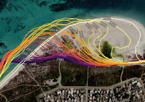
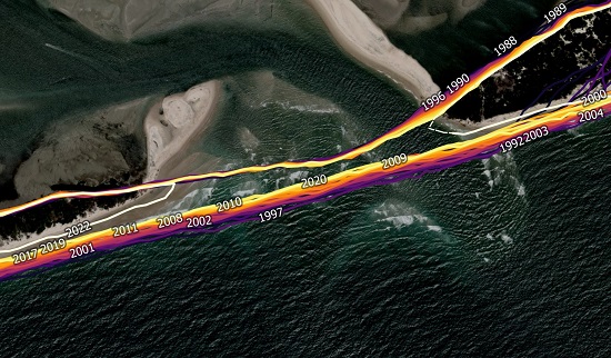
The latest release of Digital Earth Australia (DEA) Coastlines shoreline data brings the available dataset up to the year 2022.

DEA Coastlines takes satellite data and combines it with tidal modelling to map the typical location of the Australian coastline at mean sea level, year by year for every year since 1988.

The result is a representation of the national shoreline along with detailed rates of change that reveal how beaches, sandspits, river mouths and tidal flats have changed over time.

DEA Coastlines shows the two halves of Bribie Island in Queensland, formerly one island but which was split in two in January 2022 when the ocean broke through at a narrow point. Source: DEA Coastlines.

The updated version of DEA Coastlines includes 2022 continental-wide data and builds on the Coastlines 2.0 release, which incorporated data for several offshore islands and exposed reefs that had not been covered in previous releases.

As of earlier this year, Landsat 9 data has been and will continue to be added to DEA Coastlines to provide imagery from 2022 onwards, with annual dataset updates expected to be released in July each year.

You may also like to read:


, ,


Newsletter

Sign up now to stay up to date about all the news from Spatial Source. You will get a newsletter every week with the latest news.

QGIS WCPS plugin for multidimensional datacubes
The new QGIS WCPS Plugin enables seamless querying and visua...
Meet Anzu’s Raptor: Affordable, reliable & efficient
The new Raptors from Anzu Robotics are filling a much-needed...
C.R. Kennedy, Leica intern arrives in Switzerland
Phoebe Davis has begun a six-month internship with the Leica...
Multi-sensor drones
DJI has introduced the Matrice 4 Series as the company’s n...
Company behind Pokémon GO splits off spatial arm
Niantic will spin off its geospatial AI arm into a new compa...
Desktop, cloud geographic software
Blue Marble Geographics has launched Geographic Calculator 2...