A range of location datasets have been released by the UK’s Ordnance Survey (OS) as part of that nation’s Public Sector Geospatial Agreement (PSGA).
The new data and products will support users such as the emergency services, the sustainability sector, the land management sector, and the transport and property sectors, across both the public and private sectors.
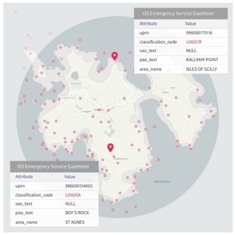
One of the new products is the OS Emergency Services Gazetteer (ESG), which will enhance the way that emergency services respond to and manage incidents. The OS ESG is a comprehensive and maintained database of locations that will contain 1.3 million features (names, places and objects), such as motorways, road junctions and roundabouts.
The OS ESG was developed in close collaboration with the emergency services community and will continue to grow over time as new features are added. It is designed to equip responders with the precise location information they need to act quickly to save lives and property during emergencies.
The ESG is particularly effective in identifying the location of areas that have no addresses, such as named cliffs and named waterfalls. It will provide a single, unified source of truth for accurate location information, aiding both those in control rooms and on the front line.
The other new product is the OS Multi-modal Routing Network, which has been developed in response to customer feedback and brings all OS transport information together in one place, reducing the effort required in preparing the data for use in routing applications.
Local authorities will be able to use the data to plan safe routes to school and colleges, and emergency services will be able to improve their emergency planning for incidents at specific locations.
The release also includes enhancements to the OS National Geographic Database (NGD) such as:
- Buildings data, which will help users develop a better understanding about the energy performance of buildings.
- New field boundary and land cover information, which is beneficial for a range of environmental sector customers, environment agencies across England, Scotland and Wales, major landowners and farmers, as well as both local and central government in delivering net zero ambitions.
- Enhancements such as the Tram Track attribution, which shows where trams are present on the road network, beneficial for road safety and street works.
The ESG, Multi-modal Routing Network and other products and services are available via the OS Data Hub.
The PSGA is a 10-year contract between the government and Ordnance Survey (OS), managed by the Geospatial Commission, for the provision of geospatial data across multiple themes, including buildings, transport, structures, addressing and land. The contract delivers key data to public sector members for use in everyday settings to support provision of critical services to the public.
The PSGA provides access to new and existing data via the OS Data Hub, including delivery of data via API and downloads. Over its term the PSGA will deliver approximately 70 new data sets and ensure the public sector has access to core foundational geospatial data that is needed to deliver effective and efficient public services.