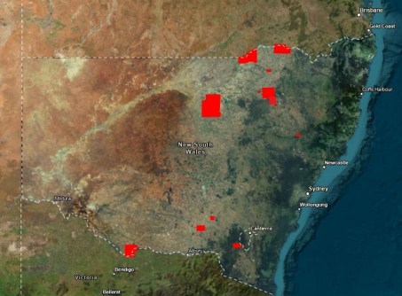
Updated imagery for 22,496 square kilometres of New South Wales has been released by DCS Spatial Services.
The latest update includes imagery for 23 areas, stretching from the Victorian border to the coast, plus Lord Howe Island.
In alphabetical order, the areas are:
- Bethungra
- Baan Baa
- Boggabilla
- Boggabri
- Carinda
- Collingullie
- Currawarna
- Galore
- Humula
- Lord Howe Island
- Mangoplah
- Moama
- Moree Plains
- Mungindi
- Murrurundi
- Narrabri
- Oura
- Quambone
- Tantangara
- Tarcutta
- Wagga Wagga
- Walcha
- Wee Waa
All of the imagery is available on the NSW Imagery Basemap, where users can access a single, consistent view of the best available aerial imagery across the state.
According to DCS Spatial Services, the Basemap combines imagery captured at different times and resolutions, balancing image quality and currency.
The data should be of use, for example, to those who are responsible for making decisions about housing, infrastructure and community matters.
The full suite of imagery can be found on the NSW Spatial Digital Explorer.
Related reading: