DR. SAMUEL HOLT, RESEARCH & DEVELOPMENT, AEROMETREX
The urban environmental crisis
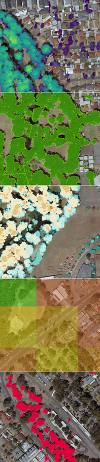
Vegetation metrics for an area in metropolitan Adelaide (from top to bottom) 1. Canopy Height Model 2. Canopy Coverage Map 3. Canopy Stratification Map 4. Canopy Coverage by Unit Area 5. Canopy Change Detection
Cities globally face many environmental challenges and governments at every level are placing great emphasis on developing environmentally sustainable urban areas. Scientific studies have shown that the presence of trees in urban areas has a wide range of positive economic, social, and environmental effects. With this understanding, there has been an increase in the efforts to measure, assess and increase the number of trees and green spaces within urban regions.
LiDAR and tree canopy management
LiDAR, which stands for Light Detection and Ranging, is an active remote sensing method that is used to accurately measure the landscape in three dimensions. The unique way in which LiDAR pulses interact with vegetation make it possible to quantify vertically distributed forest and individual tree attributes and extend traditional two- dimensional environmental models into the third dimension.
Compared to other remote sensing methods for mapping vegetation (e.g. statistical approximations, supervised classifications and artificial intelligence based two-dimensional classifiers), LiDAR explicitly measures the location of trees in three dimensions and therefore has the potential to generate more accurate measurements of the proportion and spatial distribution of tree canopy coverage across urban landscapes.
Since LiDAR models the entire three- dimensional environment and not just vegetation, it can be used for an array of critical information sets such as vegetation analysis for environmental management, individual tree segmentation for asset management, accurate building footprints for urban planning and high accuracy digital terrain models for flood modelling.
LiDAR-derived vegetation metrics
Numerous targeted vegetation metrics can be derived from LiDAR that provide management experts and policymakers actionable information that can help maintain and increase the tree assets in urban areas. Aerometrex has developed a suite of vegetation metrics that are specifically tailored towards helping state and local governments manage tree canopy within their communities as well as achieve regional environmental goals.
These include:
- Canopy Height Model (CHM) or Digital Canopy Model (DCM): a discontinuous raster that describes the height above ground of the top of tree canopies
- Canopy Coverage Map: a vector dataset showing the horizontal extent of tree canopy cover
- Canopy Coverage by Unit Area Map: a snapshot of the tree canopy coverage (%) within 100m by 100m It is a spatial distribution of tree canopy cover that is free of biases caused by calculating tree canopy coverage per council or suburb area.
- Canopy Stratification Map: a vector dataset that defines the area covered by tree canopy within defined height intervals, ranging from a lower threshold up to the maximum canopy
Urban development and associated canopy change detection
Most cities struggle to reconcile ambitious tree canopy cover targets with urban development pressures. Compared to other land cover changes, building developments are known to have a strong correlation with urban vegetation change.
Using LiDAR, you can detect change in both urban development and vegetation – accurately, and cost-effectively. Vegetation metrics can be easily compared across repeat captures to develop an understanding of the degree of change. Observations such as these are critical to assess the effectiveness of tree canopy management policies and adapting them to the dynamic challenges that will be faced by urban communities in the coming years.
Detailed vegetation analysis across metropolitan Adelaide
Recently, in collaboration with the SA state government and sixteen local councils in Greater Adelaide, Aerometrex completed a regional tree canopy assessment of metropolitan Adelaide providing a robust benchmark dataset that shall assist in the management of Adelaide’s urban forests for years to come.
Detailed vegetation analysis was carried out for 16 participating councils at a spatial resolution of 1m, providing a detailed summary of tree canopy coverage across the region, its spatial distribution and what land use and land ownership types it predominantly covers. The results of this study can be viewed online within the Department for Environment and Water’s Urban Heat and Tree Mapping viewer.
Information provided by Aerometrex.