
We are happy to announce the SAVE THE DATE for the 2019 National Conference!
Building on the success of the 2018 National Conference we are anticipating a good attendance again this year.
The Conference will be held at the Sheraton Grand Sydney Hyde Park which has recently had a $50 million refurbishment.
Call for papers will be announced shortly and more information will follow in the coming weeks.
If you have any questions please feel free to contact the Conference Manager Dean Kerr on email dean@cimages.com.au or via mobile 0422 632 608.

About this Event
Everybody talks about UAV LiDAR – the engineer in planning, the forester involved in wood mass calculation, the construction companies taking part in large projects to model it before, during and after its implementation or the utility companies for their corridor mapping and infrastructures management.
Reasons enough for us to continue the Yellowscan Demo tour in Australia, under the motto « Measuring the world with UAV LiDAR ». The scope is to show this high tech tool in a real working environment and how easy it is to generate topographic data with UAV LiDAR.
During our tour you will learn about the latest solutions and use cases from YellowScan and its partners with lectures, workshops and open discussions.
We look forward to meeting you !
YellowScan will be demonstrating two systems:
– YellowScan Surveyor Ultra, the high density & long-range LiDAR solution for UAV. Thanks to its high density (600 000 shots per second), this turn-key fully autonomous system is ideally suited for high speed & long-range projects. Its light weight (1.7 kg battery included) makes it also easy to mount on any drone.
Ideal Use cases: Mining, Archeology, Powerlines.
Applanix APX-15 & Velodyne VLP-32 inside.
– YellowScan Vx-20, the high precision & long-range LiDAR solution for UAV. This system is ideally suited for long range survey needs advanced accuracy (2,5 cm) and precision (1 cm).
Ideal Use Cases: Civil engineering, Forestry
Applanix APX-20 & Riegl miniVUX inside.
LiDAR systems are renowned for under vegetation 3D modeling, and fast data processing.
Contact :
Contact us for any question at laure.fournier@yellowscan-lidar.com
The AEGC petroleum, mineral and water resource industry conference, incorporating the ASEG-PESA International Geophysical Conference and Exhibition, will be jointly hosted by the Australian Institute of Geoscientists (AIG), Australian Society of Exploration Geophysicists (ASEG) and Petroleum Exploration Society of Australia (PESA).
Under the conference theme of Geoscience for a Sustainable World, the AEGC will attract a large number of international and national delegates and organisations from across the spectrum of Australasian geosciences, representing industry, government and academia. It is expected there will be dedicated streams for Australian basins, resourcing a sustainable energy challenge, data, innovation and technology, high-quality resources for future generations and developing the future workforce.
Registrations are now open for the Australian Institute of Mine Surveyors (AIMS) Kalgoorlie Regional Seminar, which will be held at the Kalgoorlie Bowling Club on Friday, 29 October.
The day will start at 2:30pm with an optional lawn bowls and beers social occasion, followed at 4:00pm by AIMS sessions and a sponsor interaction session. Drinks and nibbles will be supplied. Sponsors include AAM, Arvista, Caroni, Deswik, GeoCue Australia, HL Geospatial and Maptek.
There are various levels of registration fees depending upon member category. Full details can be found at the link above.
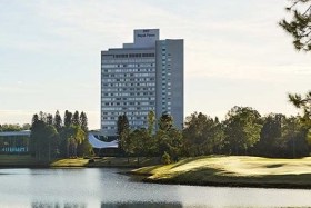
The Australian Institute of Mine Surveyors (AIMS) National Conference will be held from 25 to and 27 May 2022 at the RACV Royal Pines Resort Gold Coast, Queensland.
The conference will begin on the Wednesday with optional workshops and a welcome dinner, followed the next day by a full program of sessions on a range of topics plus networking with sponsors within the network market place. There will have a final dinner on Thursday evening at the hotel, while Friday will again see a full day of conferring and networking.
Well-known comedian Elliot Goblet (described as “one of the most original comedians in the history of the known universe”) will be the MC for the welcome dinner, while the equally well-known sporting personality Sam Kekovich has been confirmed as the keynote speaker (“you know it makes sense”).
Image credit: RACV

The FIG Congress — the largest and most prestigious conference of surveying and geospatial professionals — will this year be held in Poland.
The organisers are expecting an attendance of 1,000 to 1,500 surveying and geospatial experts from all over the world.
This year the local host is the Association of Polish Surveyors, and the conference theme is ‘Volunteering for the future – Geospatial excellence for a better living’. Geospatial excellence and all related professions and topics are now seen in a much broader context and as public goods and beneficial for the well-being and betterment of the entire society.
The sub themes are:
- Surveyor 4.0
- The surveying profession in and after COVID times
- Open access to data
- Surveying competence for other disciplines
The FIG Congress 2022 will give passionate professionals the opportunity to:
- Learn globally, with participation from around 80 to 90 countries
- Learn across silos, from other countries, industries and professional roles – with sessions and representation from a broad range of surveyors and geospatial experts
- Have influence on careers, organisations and communities
The overall theme for the FIG Working Week 2023 will be ‘Protecting our world, conquering new frontiers,’ which refers to the importance of looking ahead and discovering what will be needed in the future for our profession and at the same time make sure to preserve what works well today.
The FIG Working Week 2023 will give passionate professionals the opportunity to:
- Learn globally, with participation from around 80 to 90 countries.
- Learn across silos, from other countries, industries and professional roles, with sessions and representation from the broad range of surveyors and geospatial experts.
- Make impacts on careers, organisations and communities.

The Australian Institute of Mine Surveyors (AIMS) National Conference 2023 will be held at the Hyatt Regency Sydney from 13 to 15 September 2023. This is the premier event on the AIMS calendar and should not be missed, especially with more than 20 sponsors in attendance showcasing the latest equipment and technology.
The conference’s keynote speaker will be Peter Baines, OAM, one of Australia’s most effective ‘socialprenuers’. A former police officer, he is the founder of the well-known charity ‘Hands Across the Water,’ and as such has created opportunities for hundreds of children in Thailand.
Peter’s humanitarian efforts have been recognised with significant national and international awards. In January 2014, he was awarded the Order of Australia Medal for his International Humanitarian work. In 2016, he received the Most Admirable Order of Direkgunabhorn awarded by the King of Thailand for his devotional services to the Kingdom of Thailand.
A powerful keynote speaker, Peter’s presentations take his audience from laughter to tears as he recounts his story and delivers the lessons he has learned by managing some of the world’s most devastating crises. His tales of the way in which he has contributed to the lives of many less fortunate people in the world, and the realisation of his personal dream are absolutely inspiring.

The 4th International Symposium on Applied Geoinformatics (ISAG2024), which will take place at the Wroclaw University of Science and Technology, Wroclaw, Poland, on 9 and 10 May 2024. ISAG2024 is jointly organised by the Department of Geomatics Engineering, Yildiz Technical University, Istanbul, Türkiye, Wroclaw University of Science and Technology, Wroclaw, Poland and Technical University of Crete, Chania, Crete, Greece.
The aim of the 4th ISAG is to bring scientists, engineers and industry researchers together to exchange and share their experiences and research results and discuss the practical challenges encountered and the solutions adopted in geoinformatics.
Topics to be covered include recent advances in AI, satellite imagery, advanced remote sensing, photogrammetry, image processing, global navigation satellite systems, height systems, terrestrial laser scanning, GIS, smart cities and land management.
The International Federation of Surveyors (FIG) Working Week 2024 will be held in Accra, Ghana, from 19 to 24 May. The event is being held in cooperation with the two national associations: the Licensed Surveyors Association of Ghana (LiSAG) and the Ghana Institution of Surveyors (GhIS).
The event will comprise the following:
- Conference: 20-22 May
- FIG General Assembly: 19 and 23 May
- Pre- and post-events: 18-19 and 23 May
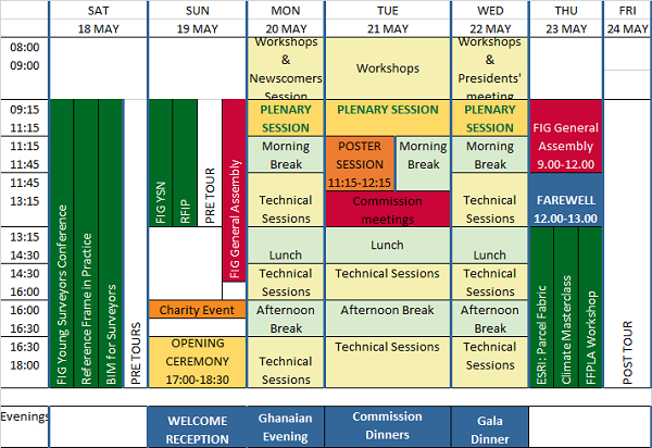
The FIG Working Week will be a week-long celebration of innovation and collaboration that unites the global community of surveying and spatial professionals, providing an opportunity to bridge the gap between science and the policymakers and stakeholders who drive real-world change.
The event will provide attendees the opportunity to:
- Immerse themselves at the forefront of geospatial technology and sustainable resource management.
- Elevate their expertise through hands-on workshops, interactive sessions, and thought-provoking discussions.
- Connect with like-minded professionals, experts and decision-makers from around the world.
The FIG Working Week 2024 is expected to attract more than 1500 attendees from around 80 countries, to participate in 70-plus presentation sessions and networking opportunities, and to experience a comprehensive trade exhibition.


