
Survey and Spatial NZ’s 2022 conference will be held from 1 to 3 August at the Novotel Lakeside, Rotorua. The conference is the biggest continuing professional development event of the year for NZ surveying and spatial professionals. It invites sharing of knowledge amongst peers, bringing together networking opportunities for all delegates and is an essential event for professional development and connectivity within the sector.
The choice of Rotorua as the location is apt, given the conference theme of ‘Turning up the Heat’. The organisers aim to stimulate discussion regarding challenges in regional areas, which include climate change and developments outside of Auckland.

Registrations for 1Spatial’s Annual Breakfast Seminar 2022 are open!
We would love to invite you to join our 3rd Annual Breakfast Seminar 2022 this October, which has limited number of seats available.
We are delighted to say that this event will be back in-person, around Australia!
Throughout the event, you will hear both customer and industry presentations that will focus on the challenges and opportunities for using and sharing geospatial data. There will be panel discussions and opportunities to network with your peers, our team, and other industry experts.
Building and Sustaining your Data Foundations
Strong data foundations are an essential requirement for the effective management of asset information and decision-making. Data needs to be accessible to organisations and their supply chain, to enable them to understand what information they have and need, what data can be upcycled sustainably, where data is located and who has access to it. To create good foundations that allow organisations to have confidence in their data, the quality, management and maintenance of that data is critical. Join us to find out more!
We look forward to welcoming you,
The 1Spatial Team
Join 1Spatial on our World Tour featuring FME!
BUILDING YOUR DATA FOUNDATIONS

The power is all yours; building stronger foundations, constructing the perfect data integration platform, and empowering the end-user all at a touch of a button. Register now!
1Spatial is hosting our very own World Tour, featuring FME. And it’s with great pleasure to be kick-starting this epic event in Australia, followed by Singapore, US and the UK!
During this Tour event, you’ll hear about the importance of foundation data and how customers trust 1Spatial’s wide range of products and solutions. You will learn how they are being used by clients all around the world and how they are saving time and money.
We are delighted to have Bob Chell, 1Spatial’s Chief Product Officer (CPO) from the UK joining the event to talk about the 1Spatial Products and how they are being used around the world.

Australian Tour dates – Register now!
- Perth – 08th May | DoubleTree by Hilton Perth Waterfront
- Adelaide – 9th May | Adelaide Convention Centre
- Hobart – 15th May | RACV Hobart Hotel
- Melbourne – 16th May Melbourne Marriott Hotel
- Canberra – 17th May | QT Canberra
- Brisbane – 18th May | Sofitel Brisbane Central
- Sydney – 19th May | Sheraton Grand Sydney Hyde Park
- Singapore – 30th May |Sheraton Towers Singapore

The Local Government Spatial Reference Group (LGSRG) will be holding a webinar on Monday, 4 September, to introduce a series of hands-on workshops it will be holding across Victoria during September 2023.
The webinar will cover the topic of Best Practice Geospatial Intelligence for Climate Impact, and will address important topics on climate impact, community safety and how geospatial intelligence can contribute to better outcomes for local governments.
The LGSRG was formed in 2003 to address the need for a sector wide group representing the strategic interests of the Victorian Local Government sector with respect to spatial information. The LGSRG has been active throughout the COVID pandemic to keep the local government geospatial community connected and engaged via the annual Spatial Capability Workshop series which have grown year on year, and is now diversifying with a quarterly Spatial Hour webinar to share stories of success within the local government geospatial sector.
Image credit: ©stock.adobe.com/au/yutthana
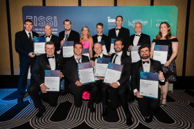
Each year representatives from the Association of Consulting Surveyors NSW and the Institution of Surveyors NSW come together to organise the NSW Excellence in Surveying and Spatial Information (EISSI) Awards.
The awards recognise the achievements of organisations and individuals from across the state who are engaged in the surveying and spatial information profession; celebrate excellence before an audience of industry peers; encourage activities that create a stronger, larger and more relevant industry; and embrace the achievements of the industry and its related industries and professions.

The Geospatial Council of Australia invites industry members to participate in the special South Australian Geospatial Excellence Awards reception on Friday, 27 October 2023, in the Riverbank Rooms at the Adelaide Convention Centre.
With no Spatial Information Day this year due to Locate23 being held in Adelaide, this event will be held to announce the 2023 South Australia award winners, whilst also showcasing some of last year’s incredible winning projects.
The evening will be an opportunity for networking with colleagues old and new, and for celebration of the local geospatial industry.
Image credit: ©stock.adobe.com/au/andy_di
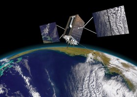
The IGNSS Association’s biennial international GNSS conference will return to UNSW Sydney from 7 to 9 February, 2024, where it will celebrate the first half-century of GNSS and look ahead to the next 50 years.
IGNSS 2024 will bring together experts, policy makers and emerging leaders from across the globe to examine the latest advances, present cutting edge research and discuss policy, market development and infrastructure.
The conference will also showcase Australia and New Zealand’s Southern Positioning Augmentation Network (SouthPAN), along with developments by other countries across the Asia-Pacific.
Topics to be covered at the conference will include:
- Autonomy on land, air, sea and in space
- Aviation and avionics
- Cooperative Intelligent Transport Systems
- Machine guidance applications in agriculture, construction and mining
- Maritime applications
- Uncrewed aerial systems
- Space applications of PNT in Earth orbit and for lunar and Martian exploration
- Positioning infrastructure
- GNSS vulnerability, resilience and risk
- Interference detection and mitigation
- Policies and standards
- SBAS and other augmentations
- Datums and geodesy
- National and international GNSS developments
- Emerging application areas for GNSS
- Key industries and their reliance on GNSS
- The multi-GNSS era
- Cyber security in PNT applications and infrastructure
- Alternative PNT
- State of the art in PNT algorithms and software development
- GNSS aiding and sensor fusion
- Positioning in GNSS denied environments
- Development of GNSS receiver hardware and firmware
- Precise position using smartphones
The organisers are encouraging early career researchers and industry representatives to present their work. The abstract submission process will open soon — keep an eye on the IGNSS website for announcements.
Image courtesy Lockheed-Martin

The not-to-be-missed Geospatial Council of Australia (GCA) South Australia Cadastral Workshop, to be held in Adelaide on 16 March, will bring together professionals in the field of land surveying and provide an opportunity for them to expand their knowledge of the complexities of cadastral surveying.
This workshop offers a unique opportunity for professionals in the field of land surveying to gather and expand their knowledge in the complexities of cadastral surveying. Participants will hear expert-led discussions into topics ranging from advanced surveying techniques to legal frameworks governing land boundaries, and gain invaluable insights to enhance their expertise and address the challenges of modern cadastral surveying practices.
- Members: $90 (incl. GST)
- Non-members: $135 (incl. GST)
- Registered survey graduates and students: $45 (incl. GST)

The Institute of Navigation’s (ION) Pacific PNT Conference is a global event dedicated to the cooperative development of positioning, navigation and timing technology and applications.
The conference attracts policy and technical leaders from Japan, Singapore, China, South Korea, Australia, the United States and many other countries, who meet to discuss policy updates, receive program status updates and exchange technical information.
The conference will cover a wide range of topics:
- GNSS policy/status
- Polynesian navigation
- Aircraft navigation and surveillance
- Algorithms and methods
- Alternative navigation and signals of opportunity
- Aviation applications of GNSS
- Challenging navigation problems
- Emerging PNT consumer applications
- GNSS-R and GNSS-RO for environmental monitoring
- High-precision GNSS correction and monitoring networks
- Inertial navigation technology and applications
- Interference and spectrum
- Ionosphere monitoring with GNSS
- Natural hazards detection and other remote sensing applications
- Time and frequency distribution
- Space navigation technologies
Substantial discounts are available for early registrations.
The International Federation of Surveyors (FIG) Working Week 2024 will be held in Accra, Ghana, from 19 to 24 May. The event is being held in cooperation with the two national associations: the Licensed Surveyors Association of Ghana (LiSAG) and the Ghana Institution of Surveyors (GhIS).
The event will comprise the following:
- Conference: 20-22 May
- FIG General Assembly: 19 and 23 May
- Pre- and post-events: 18-19 and 23 May
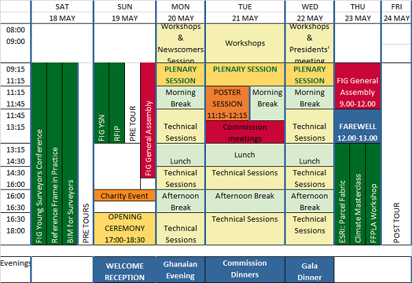
The FIG Working Week will be a week-long celebration of innovation and collaboration that unites the global community of surveying and spatial professionals, providing an opportunity to bridge the gap between science and the policymakers and stakeholders who drive real-world change.
The event will provide attendees the opportunity to:
- Immerse themselves at the forefront of geospatial technology and sustainable resource management.
- Elevate their expertise through hands-on workshops, interactive sessions, and thought-provoking discussions.
- Connect with like-minded professionals, experts and decision-makers from around the world.
The FIG Working Week 2024 is expected to attract more than 1500 attendees from around 80 countries, to participate in 70-plus presentation sessions and networking opportunities, and to experience a comprehensive trade exhibition.


