Discover what’s new and what’s next in HDS technology with immersive sessions and a day dedicated to learning, led by Leica Geosystems experts.
The HDS User Conference is designed to deliver a new experience for all attendees from Australia and New Zealand.
Together with our partners C.R. Kennedy and Global Survey the HDS User Conference will bring together Leica Geosystem HDS users in a community environment where they’ll access training sessions, learn about our latest innovations, listen to best practices from industry and experience live demos of the latest HDS technology and solutions.
The HDS User Conference features insightful keynote addresses, customer success stories and HDS dedicated group training sessions. Discover and test-drive new, innovative hardware and software solutions that will improve the performance, speed, workflows and efficiency across your organisation.
SEE AGENDA
Reasons to attend:
- Experience the latest solutions that will help you compete and win in today’s dynamic environment
- Learn about reality capture hardware and software solutions and how to be more efficient and productive
- Leica Geosystems will unveil several new innovations and attendees will get a first-hand look at the latest technology advancements
- Experience hands-on demonstrations and training to improve your workflows
- Learn from and network with peers across industries
What’s included in your registration:
- Two days filled with informative sessions and networking opportunities plus a dedicated day to learning
- Evening welcome cocktail reception
- Post-conference access to training material and presentations
- Morning tea, lunch and afternoon tea catering
- Delegate bags
NOTE: We ask that you select your preferred training session time when registering. Simply choose from the four session times available, per workshop.
This helps us manage classroom numbers to ensure we provide you with quality training sessions and you will have the opportunity to attend each topic throughout day two of the conference.
Day two- August 15
Workshop sessions and timings
Maximising 3DReshaper
9am – 10:30am I 11am- 12:30pm I 1:30pm-3:00pm I 3:30pm-5:00pm
Advanced data management and registration workflow
9am – 10:30am I 11am- 12:30pm I 1:30pm-3:00pm I 3:30pm-5:00pm
Creating diverse deliverables: optimising the latest Leica HDS software updates to transform point cloud data into value- added deliverables
9am – 10:30am I 11am- 12:30pm I 1:30pm-3:00pm I 3:30pm-5:00pm
BIM workflow
9am – 10:30am I 11am- 12:30pm I 1:30pm-3:00pm I 3:30pm-5:00pm
Visit the event page for more information
If you have any questions about the HDS User Conference, training sessions, or assistance regarding registration, please contact:
Tamara Stakic
Marketing Manager
info.anz.geo@leica-geosystems.com
T: +61 3 9914 2262
About HxGN LIVE
Arrive curious. Leave inspired.

Most of us don’t like to think about limits, especially when it comes to technology. Yet, the gap continues to grow between what is possible technologically and what industries are actually doing with that technology.
Welcome to HxGN LIVE, Hexagon’s annual digital solutions conference, where the physical world converges with the digital. This four-day, annual event welcomes thousands of business leaders from around the world who join together to experience digital solutions that improve productivity and quality across manufacturing, infrastructure, safety, and mobility applications.
More than a conference, HxGN LIVE stimulates new thinking and motivates attendees to craft new stories about disrupting the status quo, fostering innovation, and driving growth across organisations, industries, and ultimately our world. At Hexagon, we call this Shaping Smart Change.
Engage first-hand with pioneering technologies, gain a unique perspective from the industry’s top thinkers in educational keynotes and sessions, enhance your skills with interactive training, and forge new connections that grow your professional network.
HxGN LIVE is built to transform your industry, your business, and your career. Somewhere deep down in every one of us is the determination to be a difference maker, and this event welcomes thousands of leaders from a wide array of backgrounds eager to learn about the latest solutions shaping smart change around the world.
If you change nothing, nothing will change.

Join us for the first session in our ‘Locate Connect’ online learning series! Hear from Scott Dewar, Director, Chris Hewett, Assistant Secretary GEOINT Capability and Development & Phil Shears, Director DEF799 Phase 2.
In this session from 1300 – 1400, the Australian Geospatial-Intelligence Organisation (AGO) will be launching the Defence Geospatial-Intelligence (GEOINT) Strategy, a document that addresses how the Defence GEOINT Community will transform to meet the future needs of the Australian Defence Force. The AGO Executive will also provide an update on their GEOINT projects and announce upcoming opportunities for industry and discuss how the COVID-19 pandemic has impacted the organisation.
Then from 1430 – 1545, AGO, along with Frontier SI will describe how The Analytics Lab Program (AGO Labs) fits into the bigger picture of AGO capability and summarise the outcomes of their 2019 activities. AGO Labs, coordinated through FrontierSI, is investigating a number of ways to better engage and work with industry. Specifically, the AGO is keen to attract a wider pool of companies and technologies to draw on for automated geospatial intelligence. The primary focus of this program is to address AGO capability challenges through a small number of short-term industry projects, with a focus on machine learning and analytics for producing automated imagery analysis, including automated object classification. AGO will announce a new 2020 program of challenges hoping to find innovative solutions through their partnership with FrontierSI.

The Three Day Mini-Conference will be delivered in July, with 21 speakers over 3 days and taking place for 2 hours late in the afternoon. This exciting event will feature highly anticipated keynote speakers such as Bruce Thompson, Dr Karen Joyce and Nyall Dawson covering topics such as smart cities, surveying, sustainable development objectives, key projects and much, much more.
Wednesday 8 July – Friday 10 July 2020 – 1530 – 1730
Program: Download the program HERE
Cost: $90 – Mini-Conference attendee
Full access to all 3 days of the Mini-Conference, and access to the recording post-event

BEYOND THE 2026 AGENDA
The presentation will focus on a major initiative called the 2030 Space and Spatial Industry Growth Roadmap. The Government has set three key objectives for the space industry by 2030; 20,000 new jobs, $12B additional contribution to GDP and an extra one billion dollars into the investment pipeline. The combination of space and spatial working together will make a great contribution to meeting these targets. The space industry sets up critical elements of the communications supply chains (satcoms) together with content (GNSS and EO). The spatial industry provides the vast bulk of the data infrastructure, value-added content and analytics, and the ‘last yard’ delivery channels to customers. Getting this ecosystem right creates a premium competitive advantage for Australia and greatly strengthens our sovereignty and security. The presentation will discuss the next steps in the development of the roadmap; the development of a white paper which sets out the critical issues, the creation of an ecosystem map will help identify key areas for investment, and a risk analysis that will set out Australia’s critical dependence on space based assets and the steps we can take as a nation to improve our resilience, and sovereignty over, these assets. It will also provide an update on the latest developments of the 2026 Spatial Industry Transformation and Growth Agenda and how this initiative will contribute to the roadmap.

The FIG Congress — the largest and most prestigious conference of surveying and geospatial professionals — will this year be held in Poland.
The organisers are expecting an attendance of 1,000 to 1,500 surveying and geospatial experts from all over the world.
This year the local host is the Association of Polish Surveyors, and the conference theme is ‘Volunteering for the future – Geospatial excellence for a better living’. Geospatial excellence and all related professions and topics are now seen in a much broader context and as public goods and beneficial for the well-being and betterment of the entire society.
The sub themes are:
- Surveyor 4.0
- The surveying profession in and after COVID times
- Open access to data
- Surveying competence for other disciplines
The FIG Congress 2022 will give passionate professionals the opportunity to:
- Learn globally, with participation from around 80 to 90 countries
- Learn across silos, from other countries, industries and professional roles – with sessions and representation from a broad range of surveyors and geospatial experts
- Have influence on careers, organisations and communities

Each year, the Locate conference attracts hundreds of national and international delegates from within and outside the spatial and surveying industry.
As Australia’s premier spatial and surveying conference, Locate provides guests with a unique opportunity to learn about the latest trends and applications in geospatial technologies.
Are you passionate about our industry and want to get involved? Maybe you have an idea for a local tour, or a project site visit or even have another event that can run in conjunction with Locate. This is your opportunity to help shape the 2023 event — no idea is too big or too small. Reach out to the organisers via info@locateconference.com or +61 2 4319 8519.

The overall theme for the FIG Working Week 2023 will be ‘Protecting our world, conquering new frontiers,’ which refers to the importance of looking ahead and discovering what will be needed in the future for our profession and at the same time make sure to preserve what works well today.
The FIG Working Week 2023 will give passionate professionals the opportunity to:
- Learn globally, with participation from around 80 to 90 countries.
- Learn across silos, from other countries, industries and professional roles, with sessions and representation from the broad range of surveyors and geospatial experts.
- Make impacts on careers, organisations and communities.

INTERGEO returns for 2023 with the motto, ‘Inspiration for a smarter world,’ with the event this year also incorporating the German Cartography Congress.
The conference and exhibition will cover the topics of geoinformation, geodesy, land management, Earth observation, urban planning, disaster prevention, environmental protection and energy efficiency, while tackling challenges such as the climate crisis, urbanisation and securing resources.
This year, there will be a special emphasis on drone technologies and BIM.
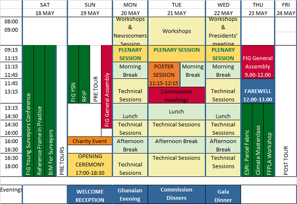
The International Federation of Surveyors (FIG) Working Week 2024 will be held in Accra, Ghana, from 19 to 24 May. The event is being held in cooperation with the two national associations: the Licensed Surveyors Association of Ghana (LiSAG) and the Ghana Institution of Surveyors (GhIS).
The event will comprise the following:
- Conference: 20-22 May
- FIG General Assembly: 19 and 23 May
- Pre- and post-events: 18-19 and 23 May

The FIG Working Week will be a week-long celebration of innovation and collaboration that unites the global community of surveying and spatial professionals, providing an opportunity to bridge the gap between science and the policymakers and stakeholders who drive real-world change.
The event will provide attendees the opportunity to:
- Immerse themselves at the forefront of geospatial technology and sustainable resource management.
- Elevate their expertise through hands-on workshops, interactive sessions, and thought-provoking discussions.
- Connect with like-minded professionals, experts and decision-makers from around the world.
The FIG Working Week 2024 is expected to attract more than 1500 attendees from around 80 countries, to participate in 70-plus presentation sessions and networking opportunities, and to experience a comprehensive trade exhibition.


