We are happy to announce the SAVE THE DATE for the 2019 National Conference!
Building on the success of the 2018 National Conference we are anticipating a good attendance again this year.
The Conference will be held at the Sheraton Grand Sydney Hyde Park which has recently had a $50 million refurbishment.
Call for papers will be announced shortly and more information will follow in the coming weeks.
If you have any questions please feel free to contact the Conference Manager Dean Kerr on email dean@cimages.com.au or via mobile 0422 632 608.

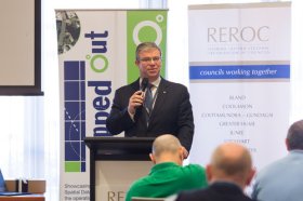
The latest in spatial data applications will be showcased at this year’s Mapped Out Conference to be held at the Rules Club in Wagga Wagga on Wednesday 2 & Thursday 3 March 2022.
Mapped Out will highlight the diversity of applications for spatial data, geographic information systems and their supporting technologies. Guest speakers with local and national experience will be showcasing the use of spatial data to enhance the operation and delivery of government services.
The Conference is a great opportunity for people working in regional NSW in both local government and the private sector to keep abreast of the latest technology and geographical information systems that can be utilised in their day to day work.

The Committee of Experts on Global Geospatial Information Management (UN-GGIM) will convene the second United Nations World Geospatial Information Congress (UNWGIC) in Hyderabad, India from 10-14 October 2022.
Hosted by the Government of India through its Ministry of Science and Technology, the convening of the UNWGIC arises out of the mandate from the United Nations Economic and Social Council (ECOSOC) to the Committee of Experts to convene global forums to promote comprehensive dialogue on global geospatial information management with all relevant governments, international organisations and stakeholders.
With an overarching theme ‘Geo-Enabling the Global Village: No one should be left behind,’ the second UNWGIC will reflect the importance of integrated geospatial information to support sustainable development and the wellbeing of society, address environmental and climate challenges, embrace digital transformation and technological development, and catalyse vibrant economies.
The congress addresses the development and strengthening of integrated geospatial information management, its capacities and capabilities, and demonstrates the importance of international cooperation and coordination for building a human data and geography community, against the three pillars of sustainable development, for a shared future and a better world, leaving no one behind within an inclusive and equitable global society.
The UNWGIC will feature a high-level, plenary, special and parallel sessions. While the actual second UNWGIC program covers three days (11 – 13 October), the overall event will be a weeklong (10 – 14 October), and will include global and regional meetings, workshops and learning events, expert meetings and side events, including the eleventh plenary meeting of the Regional Committee of United Nations Global Geospatial Information Management for Asia and the Pacific (UN-GGIM-AP), as well as the annual meeting of the UN-GGIM Expanded Bureau.

The International Cartographic Association (ICA) invites you to share your research, practice and experiences in cartography and GIScience at the 31st International Cartographic Conference (ICC 2023), to be held from 13 to 18 August 2023 in Cape Town, South Africa.
The conference theme will be ‘Smart Cartography for Sustainable Development’.
Important dates:
- 5 December 2022 – Submission of full papers closes
- 12 December 2022 – Submission of abstracts closes
- February 2023 – Conference registration opens
- 28 February 2023 – Notification of acceptance
- 8 May 2023 – Submission of revised abstracts and papers
- 15 May 2023 – Early Bird registration closes
- 15 May 2023 – Registration deadline for presenters of abstracts, papers and posters

The Local Government Spatial Reference Group (LGSRG) will be holding a webinar on Monday, 4 September, to introduce a series of hands-on workshops it will be holding across Victoria during September 2023.
The webinar will cover the topic of Best Practice Geospatial Intelligence for Climate Impact, and will address important topics on climate impact, community safety and how geospatial intelligence can contribute to better outcomes for local governments.
The LGSRG was formed in 2003 to address the need for a sector wide group representing the strategic interests of the Victorian Local Government sector with respect to spatial information. The LGSRG has been active throughout the COVID pandemic to keep the local government geospatial community connected and engaged via the annual Spatial Capability Workshop series which have grown year on year, and is now diversifying with a quarterly Spatial Hour webinar to share stories of success within the local government geospatial sector.
Image credit: ©stock.adobe.com/au/yutthana

The Australian Institute of Mine Surveyors (AIMS) National Conference 2023 will be held at the Hyatt Regency Sydney from 13 to 15 September 2023. This is the premier event on the AIMS calendar and should not be missed, especially with more than 20 sponsors in attendance showcasing the latest equipment and technology.
The conference’s keynote speaker will be Peter Baines, OAM, one of Australia’s most effective ‘socialprenuers’. A former police officer, he is the founder of the well-known charity ‘Hands Across the Water,’ and as such has created opportunities for hundreds of children in Thailand.
Peter’s humanitarian efforts have been recognised with significant national and international awards. In January 2014, he was awarded the Order of Australia Medal for his International Humanitarian work. In 2016, he received the Most Admirable Order of Direkgunabhorn awarded by the King of Thailand for his devotional services to the Kingdom of Thailand.
A powerful keynote speaker, Peter’s presentations take his audience from laughter to tears as he recounts his story and delivers the lessons he has learned by managing some of the world’s most devastating crises. His tales of the way in which he has contributed to the lives of many less fortunate people in the world, and the realisation of his personal dream are absolutely inspiring.

The 2024 edition of the International Conference on Geographical Information Systems Theory, Applications and Management (GISTAM 2024) aims to create a meeting point of researchers and practitioners that address new challenges in geo-spatial data sensing, observation, representation, processing, visualization, sharing and managing, in all aspects concerning both ICT as well as management information systems and knowledge-based systems.
The conference welcomes original papers of either practical or theoretical nature, presenting research or applications, of specialised or interdisciplinary nature, addressing any aspect of geographic information systems and technologies, such as:
- Data acquisition and processing
- Remote sensing
- Interaction with spatial-temporal information
- Spatial data mining
- Managing spatial data
- Modelling, representation and visualisation
- GIS and climate change
- Domain applications

The 4th International Symposium on Applied Geoinformatics (ISAG2024), which will take place at the Wroclaw University of Science and Technology, Wroclaw, Poland, on 9 and 10 May 2024. ISAG2024 is jointly organised by the Department of Geomatics Engineering, Yildiz Technical University, Istanbul, Türkiye, Wroclaw University of Science and Technology, Wroclaw, Poland and Technical University of Crete, Chania, Crete, Greece.
The aim of the 4th ISAG is to bring scientists, engineers and industry researchers together to exchange and share their experiences and research results and discuss the practical challenges encountered and the solutions adopted in geoinformatics.
Topics to be covered include recent advances in AI, satellite imagery, advanced remote sensing, photogrammetry, image processing, global navigation satellite systems, height systems, terrestrial laser scanning, GIS, smart cities and land management.


