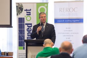
The latest in spatial data applications will be showcased at this year’s Mapped Out Conference to be held at the Rules Club in Wagga Wagga on Wednesday 2 & Thursday 3 March 2022.
Mapped Out will highlight the diversity of applications for spatial data, geographic information systems and their supporting technologies. Guest speakers with local and national experience will be showcasing the use of spatial data to enhance the operation and delivery of government services.
The Conference is a great opportunity for people working in regional NSW in both local government and the private sector to keep abreast of the latest technology and geographical information systems that can be utilised in their day to day work.

Survey and Spatial NZ’s 2022 conference will be held from 1 to 3 August at the Novotel Lakeside, Rotorua. The conference is the biggest continuing professional development event of the year for NZ surveying and spatial professionals. It invites sharing of knowledge amongst peers, bringing together networking opportunities for all delegates and is an essential event for professional development and connectivity within the sector.
The choice of Rotorua as the location is apt, given the conference theme of ‘Turning up the Heat’. The organisers aim to stimulate discussion regarding challenges in regional areas, which include climate change and developments outside of Auckland.
The Geo Connect Asia conference provides a strategic and collaborative platform for industry professionals, government agencies and start-ups to come together to build and develop knowledge and solutions for Asia’s geospatial & location intelligence markets. It also comprises panel sessions to provide interactive responses to real and current challenges.
Geo Connect Asia 2023 (GCA 2023) will have full focus on a face-to-face show format, featuring more hands-on opportunities for visitors to experience different elements, modules and applications of geospatial data.
GCA 2023 will also see the launch of a dedicated UAV-focused industry show, Drones Asia, covering an entire hall with several on-site showcases of drones, cameras, launch & recovery systems, and sensors, as well as the latest technology for satellite & remote sensing, launch & recovery systems, surveillance & reconnaissance, and training & simulation.
Geo Connect Asia is your gateway to meeting some of the world’s biggest players in geospatial technology and location intelligence solutions, right at the heart of Singapore.
Key Industries
![]()
![]()
![]()
![]()
![]()
![]()
![]()
![]()
![]()
If you are interested in knowing about conference sponsorship opportunities and/or meeting spaces at GCA 2023, please contact Rupert.Owen@montgomeryasia.com.
XPONENTIAL is a leading annual gathering for global leaders and end users of uncrewed technologies. Founded on a belief that cross-pollination drives innovation, it’s the only event designed to advance the entire autonomy ecosystem. Each year, it welcomes thousands of the industry’s top minds to cultivate collaboration, spark new ideas, and in 2023, build the blueprint for autonomy. XPONENTIAL is a catalyst — helping each attendee transform their vision into real opportunities.


The World of Drones and Robotics Congress New Zealand (WoDaRC NZ) is shaping up as an unmissable event for anyone involved in robotics, drones, AI, AgTech and data-led innovation. WoDaRC is business-led, technology based and will create opportunities for collaboration and growth across the technology ecosystem.
Topics to be covered include:
- Regional capability and strategy
- Humanitarian engineering and disaster response
- Environmental science and agricultural technology
- The new frontiers: oceans, mountains, and space
- Movies, media, community, and social empowerment
- Education

RPAS in Australia Skies is back for 2023. The conference is the Australian Association for Uncrewed Systems’ (AAUS) main event for the year and has established itself as a landmark event for the Australian drone industry, drawing interest from key government personnel, representatives from the regulatory and safety bodies, defence force, RPAS and UTM representatives, end users and academia.
The hybrid event will take place over two days and will include a combination of presentations and interactive panel discussions.
The conference will cover:
- RPAS related policy and regulatory updates from Australian and international government agencies.
- UAS Traffic Management, low-level airspace and integrated airspace systems
- Industry challenges and perspectives
- Continuing development of a professional and safe industry.
- Emerging technologies and innovative solutions enabling RPAS integration in Australian airspace.
- Emerging applications — benefits, viability and social acceptance
- Case studies of drone use and challenges in emergency services, infrastructure inspection, delivery, mining, and agriculture.

Hosted by the Riverina Eastern Regional Organisation of Councils and the Riverina Spatial Information Group, Mapped Out 2023 will bring together public- and private-sector professionals to learn about the latest geospatial developments.
Mapped Out will highlight the diversity of applications for spatial data, geographic information systems and their supporting technologies. Guest speakers with local and national experience will be showcasing the use of spatial data to enhance the operation and delivery of government services.
The Conference is a great opportunity for people working in regional NSW in both local government and the private sector to keep abreast of the latest technology and geographical information systems that can be utilised in their day-to-day work.

The 2024 edition of the International Conference on Geographical Information Systems Theory, Applications and Management (GISTAM 2024) aims to create a meeting point of researchers and practitioners that address new challenges in geo-spatial data sensing, observation, representation, processing, visualization, sharing and managing, in all aspects concerning both ICT as well as management information systems and knowledge-based systems.
The conference welcomes original papers of either practical or theoretical nature, presenting research or applications, of specialised or interdisciplinary nature, addressing any aspect of geographic information systems and technologies, such as:
- Data acquisition and processing
- Remote sensing
- Interaction with spatial-temporal information
- Spatial data mining
- Managing spatial data
- Modelling, representation and visualisation
- GIS and climate change
- Domain applications


