A platform that maps vegetation across Greater Hobart in order to assess the potential exposure of residential buildings and communities to bushfires, has been given a substantial update.
The 2024 Greater Hobart Bushfire Exposure Index has been produced by geospatial technology and climate risk analysis firm Geoneon, with grant funding provided by the Australian Government.
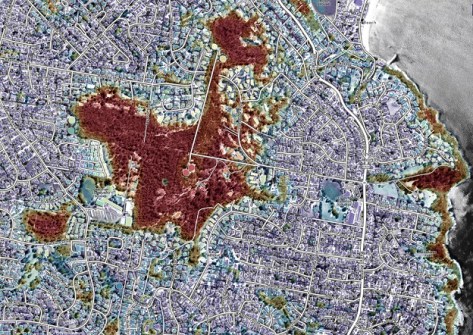
The Index updates an earlier version from 2022 and offers expanded insights into bushfire severity and exposure across the Greater Hobart region.
The project aims to provide vital information for communities, local governments and emergency services as the summer bushfire season approaches.
The 2024 update incorporates new data for the Clarence, Sorell and Brighton council areas, adding to the original coverage of Hobart, Kingborough and Glenorchy.
The 2024 platform update provides:
- Bushfire Hazard Severity Index: A detailed assessment of potential fire severity based on factors such as vegetation density and topography.
- Bushfire Exposure Index: A measure of building exposure to bushfires, focusing on proximity to bushland and surrounding vegetation.
- Interactive Mapping: A web platform visualising bushfire severity and exposure levels across Greater Hobart.
According to Anna Reynolds, Lord Mayor of Hobart, the city is taking a “proactive approach to bushfire preparedness,” having recently endorsed a Climate Ready Hobart Strategy that will guide how it responds to climate and biodiversity emergencies.
“The updated platform will play a critical role in our bushfire resilience efforts. It will help our community stay informed and better prepared,” Reynolds said.
“We are committed to equipping communities and authorities with the tools they need to make informed decisions about bushfire risk,” said Geoneon’s CEO, Roxane Bandini-Maeder.
“This platform update offers more detailed and accurate data than ever before, enabling us to build a safer and more resilient future for Greater Hobart.”