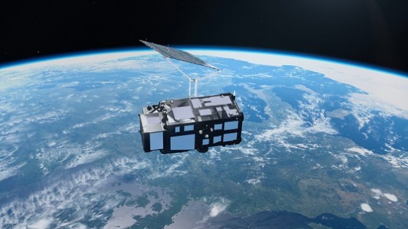
Only two weeks after it was launched, Europe’s new Copernicus Sentinel-3C Earth observation satellite has begun showing off its prowess.
Early images and data from two of Sentinel-3C’s instruments has already shown what is capable of, as mission controllers begin five months of commissioning work.
Sentinel-3C’s role is to monitor the state of the Earth’s oceans, land surface, cryosphere and atmosphere.
The third spacecraft in the Sentinel-3 series, it carries the same suite of instruments as the other two satellites, to ensure continuity in the environmental data delivered by the overall mission.
Sentinel-3’s ocean mission includes measuring the temperature, colour and height of the sea surface, plus the thickness of sea ice. Such measurements will be used to support studies into marine pollution and marine heatwaves.
Its land mission will monitor floods, drought and fires, map land use, monitoring vegetation health, and measure the height of lakes, rivers and polar ice sheets.
Sentinel-3 in numbers
- Launch: Sentinel-3A in 2016 and Sentinel-3B in 2018 (Rockot, from Plesetsk, Russia), and Sentinel-3C in 2026 (Vega-C, from Europe’s Spaceport, French Guiana)
- Orbit: Polar, Sun-synchronous at an average altitude of 814.5 km
- Lifetime: Designed for seven years (carrying consumables for 12 years)
- Size: 2.2 m long, 2.2 m wide, 3.7 m high and a mass of 1,150 kg (including 130 kg fuel)
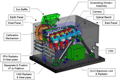
- Instrument1: Ocean and Land Colour Instrument covering 21 spectral bands (400–1020 nm) with a swath width of 1270 km.
- Instrument2: Sea and Land Surface Temperature Radiometer covering 9 spectral bands (555–12 000 nm), dual-view scan with swath widths of 1400 km (nadir) and 740 km (oblique view), two dedicated fire channels.
- Instrument3: Synthetic Aperture Radar Altimeter, Ku-band (300 m after SAR processing) and C-band.
- Instrument4: Microwave Radiometer, dual-frequency at 23.8 & 36.5 GHz
Land and oceans under observation
Sentinel-3C’s first-released images provide amazing views of Italy, the Arctic and the Caribbean, synthesised from data collected by the satellite’s Ocean and Land Colour Instrument (OLCI).
The OLCI comprises a five-camera array that observes in 21 different bands, with a native acquisition resolution of about 300 metres.
One of the OLCI’s first views shows a broad swath that stretches from southern Germany in the north to Sicily and the southern Mediterranean in the south.
The natural-colour view takes in the Po Valley (an agricultural region), the snow-topped Alps, the Adriatic Sea, the Tyrrhenian Sea with the islands of Sardinia, Sicily and Corsica.

Another image shows part of the Canadian Arctic Archipelago, to the west of Greenland, while the third image shows part of the Caribbean, with Cuba to the south and the Bahamas near top of the image.


Ocean measurements and ice investigations
Sentinel-3C’s other main instrument, a synthetic aperture radar (SAR) altimeter, will be used to measure sea surface height changes to help monitor sea rise and contribute understandings of climate change.
The map below shows measurements of sea-surface height across the Atlantic Ocean and Mediterranean Sea from Sentinel-3C’s SAR altimeter, compared to the Copernicus Marine Service multi-mission sea-level anomaly. These new data reveal that the altimeter is performing well.

Once fully commissioned, the altimeter will contribute to monitoring global changes in sea-surface height, adding to long-term data collected from missions such as Copernicus Sentinel-6 and Jason.
High-precision satellite altimetry has helped establish the rate of global sea-level rise, which has averaged 3.64 mm per year since 1999 and accelerating.
Sentinel-3C’s altimeter will also measure changes in the height of lakes, rivers, sea ice and land ice. Its first look at the Greenland Ice Sheet shows that the altimeter is working as planned, with its data closely matching the reference digital elevation model.
Related reading:
Satellite regional data hub celebrates 10 years
Launches add to Earth observation satellite fleets