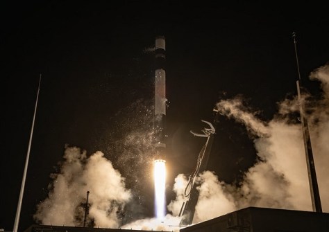
The Earth observation sector has been given a boost following two recent launches by Rocket Lab and the Indian Space Research Organisation (ISRO).
The satellites launched on both flights will be used to enhance disaster management, environmental monitoring and high-frequency spatial data collection.
Rocket Lab launched the latest StriX synthetic aperture radar (SAR) satellite for Japanese geospatial provider Synspective, placing it into a 575-kilometre low Earth orbit.
Operating at X-band wavelengths, the SAR payload is designed to capture high-resolution imagery regardless of weather conditions or sunlight, providing crucial data for commercial mapping, infrastructure checks, and emergency response operations.
Meanwhile, ISRO achieved a major milestone with the launch of its EOS-05 (GISAT-1A) geo-imaging satellite aboard a GSLV-F17 rocket.
Unlike standard low-Earth-orbit remote sensing spacecraft, EOS-05 will operates from geostationary orbit, making it India’s first imaging satellite to operate from that high vantage point.
This unique positioning will enable the spacecraft to provide continuous, near-real-time monitoring of the subcontinent.
By acquiring frequent multi-spectral and hyper-spectral images, the mission aims to significantly bolster rapid response capabilities for fast-evolving natural disasters such as cyclones, floods, and forest fires, alongside long-term agricultural tracking.
Meanwhile, the next two European Space Agency Earth observation satellites are being prepared for launch in the middle of this month.
The FLEX and Sentinel-3C spacecraft have now been enclosed within the protective fairing of their Vega-C rocket.
FLEX — the Fluorescence Explorer — is designed to measure the faint fluorescence emitted by plants as they photosynthesise. The mission is expected to produce global maps of vegetation fluorescence at a resolution of 300 x 300 metres, offering a new way to study how plants interact with the atmosphere and how carbon and water move through Earth’s ecosystems.
Sentinel-3C, the third satellite in the Sentinel-3 series, will continue the program’s monitoring of Earth’s oceans, land, ice and atmosphere.