

The latest version of the Tessera foundation Earth observation model has been released to researchers worldwide.
Tessera, which stands for temporal Embeddings of Surface Spectra for Earth Representation and Analysis, is an AI-powered model.
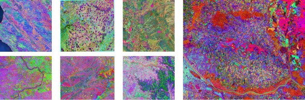
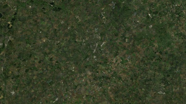
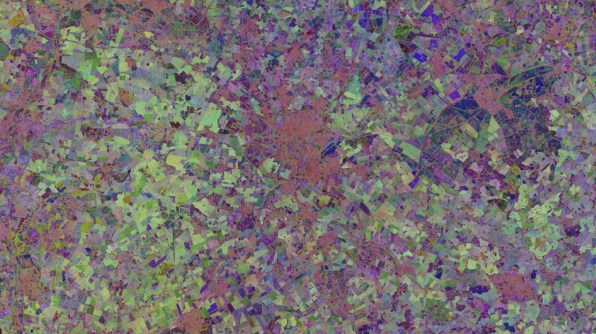
It takes Copernicus Sentinel-1 and Sentinel-2 data and produces high-accuracy datasets that encode what the satellites record over the course of a year.
The model’s datasets — known as embeddings — can be used to produce information-rich maps from highly compressed versions of the original satellite imagery.
Although the model was first released in 2025, a paper presented at a computer conference earlier this month marked the release of its first, fully peer-reviewed version.
Tessera was developed by researchers at the University of Cambridge with collaboration from partners around the world.
According to co-lead of the project, Professor Srinivasan Keshav from the University of Cambridge, Tessera addresses some of the challenges of working with the huge amounts of data produced by the Copernicus program.
“Our embeddings make the data more accessible to users from traditionally unserved communities, especially those from ecology, conservation, plant science and zoology,” he said.
“We’ve also made these available without requiring registration and at no cost, opening the door to many new classes of critical problems.”
What does Tessera do?
One of the most important aspects of the model is that the data is already trained, so they contain insights and patterns that do not need to be discerned from scratch.
Thus, researchers who aren’t AI experts can dive right in and take the highly compressed data and use it straight away.
Importantly, these embeddings are sufficiently ‘lightweight’ that they can be used on laptops or other mobile devices.
According to Tessera, “Over 90% of final task performance is achievable using less than 1% of available labelled data”.
Its open-source nature is another plus, providing access to data that might otherwise be unavailable to many potential users.
“Foundation models are the new frontier of AI applied to remote-sensing data,” said Nuno Miranda, Mission Manager for Sentinel-1 at the European Space Agency (ESA).
“Tessera demonstrates how data from the Sentinel-1 and Sentinel-2 missions can be applied in practice, helping users to analyse and understand the Earth system more efficiently.”
How does it work?
The AI model fuses Sentinel-1 synthetic aperture radar data with Sentinel-2 optical data into year-long ‘global embeddings’ that span the period 2017 to 2025.
That data is compressed and reduced to 10-metre resolution. Each 10-metre pixel holds a time series of data for that location for a year.
The result is a recording of how things changed at each location over 12 months, presented in such a way that searches can be made within the data.
“The adoption of embeddings represents a paradigm shift,” said Cambridge’s Professor Keshav.
“Instead of distributing heavy imagery, models such as Tessera can now provide downstream users with compressed semantic representations of the information of Earth’s surface embedded in the original data.”
Putting Tessera to use
The capability will be especially useful for researchers and other users who are involved in environmental monitoring.
For instance, in the UK, researchers are using the model to evaluate the efficacy of the UK government’s nature protection schemes in Cumbria in northern England.
The project — which is a partnership between Tessera, the Endangered Landscapes and Seascape Programme and other UK entities — might prove helpful in demonstrating the effectiveness of investments in nature conservation and farming subsidies.
“Monitoring these environmental changes over vast scales is exactly the sort of problem that Tessera was designed to solve,” said the University of Cambridge’s Professor David Coomes, a co-lead and senior researcher with the Cumbria project.


