

The Copernicus Australasia Regional Data Hub has celebrated its 10th anniversary.
The Regional Data Hub is a partnership between the WA, QLD, NSW State Governments, CSIRO and Geoscience Australia.
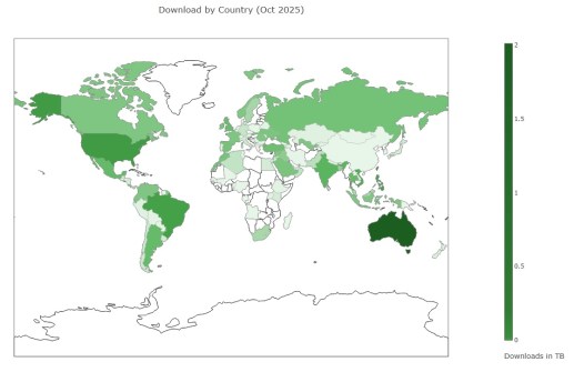
It mirrors parts of Europe’s data repository and provides access to data covering the Indo-Pacific region that has been accumulated from the Sentinel-1, Sentinel-2, Sentinel-3 and Sentinel-5P missions since 2016.
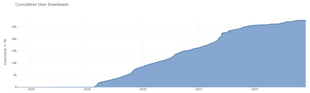
That data has grown to a current total of 6.5 petabytes.
The system, which is located at and operates from the National Computational Infrastructure in Canberra, automatically checks for new data on an hourly basis.
That data comes from the European Space Agency (ESA) and the European Organisation for the Exploitation of Meteorological Satellites (EUMETSAT) hubs.
The aim is to ensure that 90% of the data obtained from the European hubs is made available within 24 hours of receipt.
Freely available Copernicus data
“Geoscience Australia established its partnership with the European Commission’s Copernicus Programme around a decade ago to improve Australia’s resilience in international Earth observation data supply and to improve access for users across our region,” said David Hudson, Geoscience Australia’s Branch Head, Satellite Land Imaging Collection.
“By negotiating priority access to Copernicus Sentinel data, Geoscience Australia enabled more timely, reliable and streamlined delivery of satellite information across Australasia and the broader Indo-Pacific,” he added.
According to Hudson, the collaboration and establishment of the Copernicus Australasia Regional Data Hub has resulted in:
- reduced duplication across jurisdictions
- lowered technical barriers for users in government, research and industry, and
- strengthened national and regional capability in the use of EO data.
Hudson says the data is freely and openly available to all users and underpins a wide range of applications, supporting more than 170 programs across government as well as research and industry.
“The partnership has delivered significant value by enabling better environmental monitoring, supporting decision-making, and reinforcing Australia’s reputation as a trusted leader in the management and application of Earth observation data in the Southeast Asia and South Pacific regions,” he said.
Next steps for the Copernicus partnership
“Geoscience Australia is focused on ensuring the Copernicus partnership continues to deliver long-term value by preparing for the next generation of Earth observation missions, including upcoming Sentinel Next Generation capabilities,” said Hudson.
This includes modernising the data delivery systems to support increased data volumes and more advanced applications.
“Together, these efforts will ensure Australia remains well positioned to maximise the benefits of Earth observation data for decision-making across the region,” said Hudson.


